FAA INFORMATION EFFECTIVE 22 JANUARY 2026
Location
| FAA Identifier: | P45 |
| Lat/Long: | 40-06-27.6216N 079-32-35.0667W
40-06.460360N 079-32.584445W
40.1076727,-79.5430741
(estimated) |
| Elevation: | 1160 ft. / 354 m (estimated) |
| Variation: | 08W (1985) |
| From city: | 3 miles S of MOUNT PLEASANT, PA |
| Time zone: | UTC -5 (UTC -4 during Daylight Saving Time) |
| Zip code: | 15666 |
Airport Operations
| Airport use: | Open to the public |
| Activation date: | 03/1947 |
| Control tower: | no |
| ARTCC: | CLEVELAND CENTER |
| FSS: | ALTOONA FLIGHT SERVICE STATION |
| NOTAMs facility: | AOO (NOTAM-D service available) |
| Attendance: | IRREGULAR |
| Wind indicator: | yes |
| Segmented circle: | no |
Airport Communications
| CTAF: | 122.9 |
| WX AWOS-3P at VVS (10 nm SW): | 133.325 (724-626-8745) |
| WX AWOS-3 at LBE (12 nm NE): | PHONE 724-537-0671 |
| WX AWOS-3 at FWQ (15 nm NW): | 118.475 (724-379-5815) |
Nearby radio navigation aids
| VOR radial/distance | | VOR name | | Freq | | Var |
|---|
| AGCr123/25.0 | | ALLEGHENY VOR/DME | | 110.00 | | 09W |
| JSTr255/34.8 | | JOHNSTOWN VOR/DME | | 113.00 | | 06W |
| MGWr029/36.1 | | MORGANTOWN VOR/DME | | 111.60 | | 05W |
Airport Services
| Fuel available: | 100LL |
| Parking: | hangars and tiedowns |
| Bottled oxygen: | NONE |
| Bulk oxygen: | NONE |
Runway Information
Runway 6/24
| Dimensions: | 2037 x 135 ft. / 621 x 41 m |
| Surface: | turf, in good condition |
| Operational restrictions: | MKD WITH YELLOW CONES. |
| RUNWAY 6 | | RUNWAY 24 |
| Latitude: | 40-06.374833N | | 40-06.579833N |
| Longitude: | 079-32.681167W | | 079-32.335000W |
| Elevation: | 1114.0 ft. | | 1150.0 ft. |
| Traffic pattern: | left | | left |
| Runway heading: | 061 magnetic, 053 true | | 241 magnetic, 233 true |
| Markings: | NSTD, in good condition | | NSTD, in good condition |
| Obstructions: | 38 ft. trees, 540 ft. from runway, 162 ft. right of centerline, 14:1 slope to clear | | 11 ft. tree, 61 ft. from runway, 48 ft. right of centerline, 5:1 slope to clear |
Runway 14/32
| Dimensions: | 1625 x 175 ft. / 495 x 53 m |
| Surface: | turf, in good condition |
| Operational restrictions: | MKD WITH YELLOW CONES. |
| RUNWAY 14 | | RUNWAY 32 |
| Latitude: | 40-06.525333N | | 40-06.352833N |
| Longitude: | 079-32.813167W | | 079-32.547167W |
| Elevation: | 1093.0 ft. | | 1135.0 ft. |
| Traffic pattern: | left | | left |
| Runway heading: | 138 magnetic, 130 true | | 318 magnetic, 310 true |
| Displaced threshold: | 565 ft. | | 250 ft. |
| Markings: | NSTD, in good condition | | NSTD, in good condition |
| Obstructions: | 12 ft. road, 4 ft. from runway, 100 ft. left of centerline
RWY 14 APCH RATIO 20:1 TO 565 FT DTHR. | | 25 ft. trees, 204 ft. from runway, 87 ft. right of centerline, 8:1 slope to clear
RWY 32 APCH RATIO 57 FT TREES, 747 FT FM THLD, 64 FT R 17:1 TO 250 FT DTHR. |
Airport Ownership and Management from official FAA records
| Ownership: | Privately-owned |
| Owner: | MT. PLEASANT AIRPORT LLC
276 AIRPORT RD
MOUNT PLEASANT, PA 15666
Phone 724-220-5556 |
| Manager: | WILLIAM C. HOFFMAN
276 AIRPORT RD
MOUNT PLEASANT, PA 15666
Phone 814-442-1747 |
Additional Remarks
| - | RWYS UNUSBL DURG SPRING THAW & WET PERIODS. |
| - | FOR CD CTC JOHNSTOWN APCH AT 814-532-5960, WHEN APCH CLSD CTC CLEVELAND ARTCC AT 440-774-0213. |
| - | EXTSV HEL ACTVTY AT ADJ HELI. |
| - | ULTRALIGHT ACTVTY ON & INVOF ARPT. |
| - | BOTH RWY SFCS ARE ROLLING. |
| - | ULTRALIGHT ACFT USE 500 FT AGL R TFC PAT FOR ALL RWYS. |
| - | WILDLIFE ON & INVOF RWYS. |
| - | RWY NOT MNTND DRG WINTER MONTHS. |
| - | SEASONAL CROPS LCTD ARND RWYS. |
Instrument Procedures
There are no published instrument procedures at P45.
Some nearby airports with instrument procedures:
KVVS - Joseph A Hardy Connellsville Airport (10 nm SW)
KLBE - Arnold Palmer Regional Airport (12 nm NE)
KFWQ - Rostraver Airport (15 nm NW)
G05 - Finleyville Airpark (23 nm W)
KAGC - Allegheny County Airport (23 nm NW)
|
|

Road maps at:
MapQuest
Bing
Google
| Aerial photo |
|---|
WARNING: Photo may not be current or correct

Do you have a better or more recent aerial photo of Mount Pleasant/Scottdale Airport that you would like to share? If so, please send us your photo.
|
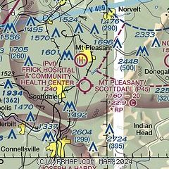
| Sectional chart |
|---|
|
| Airport distance calculator |
|---|
|
|
| Sunrise and sunset |
|---|
|
Times for 16-Feb-2026
| | Local
(UTC-5) | | Zulu
(UTC) |
|---|
| Morning civil twilight | | 06:43 | | 11:43 |
| Sunrise | | 07:11 | | 12:11 |
| Sunset | | 17:54 | | 22:54 |
| Evening civil twilight | | 18:21 | | 23:21 |
|
| Current date and time |
|---|
| Zulu (UTC) | 17-Feb-2026 00:18:57 |
|---|
| Local (UTC-5) | 16-Feb-2026 19:18:57 |
|---|
|
| METAR |
|---|
KVVS
10nm SW | 162355Z AUTO 00000KT 10SM CLR 04/01 A3012 RMK AO2 T00370015 10079 20032 400791012
|
KLBE
12nm NE | 162355Z 00000KT 9SM CLR 03/02 A3013
|
KP53
15nm NW | 162356Z AUTO 00000KT 01/M01 A2991 RMK AO1 SLP138 T00061006 10050 20006 51026 $
|
|
| TAF |
|---|
KLBE
12nm NE | 170014Z 1700/1724 22007KT P6SM SCT015 FM170300 21004KT 4SM BR BKN025 TEMPO 1708/1712 1SM BR OVC005 FM171700 21004KT P6SM SCT060
|
|
| NOTAMs |
|---|
NOTAMs are issued by the DoD/FAA and will open in a separate window not controlled by AirNav.
|
|

