FAA INFORMATION EFFECTIVE 22 JANUARY 2026
Location
| FAA Identifier: | S20 |
| Lat/Long: | 45-49-55.4660N 120-50-42.9890W
45-49.924433N 120-50.716483W
45.8320739,-120.8452747
(estimated) |
| Elevation: | 1678 ft. / 511 m (estimated) |
| Variation: | 19E (1985) |
| From city: | 1 mile NW of GOLDENDALE, WA |
| Time zone: | UTC -8 (UTC -7 during Daylight Saving Time) |
| Zip code: | 98620 |
Airport Operations
| Airport use: | Open to the public |
| Activation date: | 06/1958 |
| Control tower: | no |
| ARTCC: | SEATTLE CENTER |
| FSS: | SEATTLE FLIGHT SERVICE STATION |
| NOTAMs facility: | SEA (NOTAM-D service available) |
| Attendance: | UNATNDD |
| Wind indicator: | lighted |
| Segmented circle: | no |
| Lights: | ACTIVATE MIRL RWY 07/25 - CTAF. |
| Beacon: | white-green (lighted land airport)
Operates sunset to sunrise. |
Airport Communications
| CTAF: | 122.9 |
| WX ASOS at DLS (19 nm SW): | 135.175 (509-767-1726) |
Nearby radio navigation aids
| VOR radial/distance | | VOR name | | Freq | | Var |
|---|
| LTJr035/12.8 | | KLICKITAT VOR/DME | | 112.30 | | 21E |
Airport Services
| Fuel available: | 100LL |
| Parking: | tiedowns |
| Airframe service: | NONE |
| Powerplant service: | NONE |
| Bottled oxygen: | NONE |
| Bulk oxygen: | NONE |
Runway Information
Runway 7/25
| Dimensions: | 3491 x 40 ft. / 1064 x 12 m |
| Surface: | asphalt, in good condition |
| Weight bearing capacity: | |
| Runway edge lights: | medium intensity |
| Runway edge markings: | NONSTD WHITE LINE CROSSES RWY NEAR RWY 25 MARKING. |
| RUNWAY 7 | | RUNWAY 25 |
| Latitude: | 45-49.919050N | | 45-49.929800N |
| Longitude: | 120-51.127233W | | 120-50.305733W |
| Traffic pattern: | left | | left |
| Runway heading: | 070 magnetic, 089 true | | 250 magnetic, 269 true |
| Displaced threshold: | no | | 330 ft. |
| Markings: | NSTD, in good condition | | NSTD, in good condition |
| Visual slope indicator: | | | 2-box SAVASI on left |
| Obstructions: | 15 ft. gnd, 475 ft. from runway, 18:1 slope to clear
4 FT FENCE 111 FT RIGHT & BOULDERS AT 0 FT & 80 FT RIGHT OF CNTRLN. | | 95 ft. trees, 2573 ft. from runway, 125 ft. both sides of centerline, 24:1 slope to clear
4 FT FENCE 65 FT, DITCH 67 FT, ROAD 81 FT FM THR AND FENCE AT 124 FT. |
Airport Ownership and Management from official FAA records
| Ownership: | Publicly-owned |
| Owner: | CITY OF GOLDENDALE
1103 SOUTH COLUMBUS, P.O. BOX 69
GOLDENDALE, WA 98620
Phone 509-773-3771 |
| Manager: | RICHARD LUNDIN
1103 SOUTH COLUMBUS, P.O. BOX 69
GOLDENDALE, WA 98620
Phone 509-314-0564 |
Additional Remarks
| - | FENCES, DITCH, BOULDERS, BLDGS & ROAD IN PRIMARY SURFACE. |
| - | DEER AND WILDLIFE INVOF ARPT. |
| - | FOR CD CTC SEATTLE ARTCC AT 253-351-3694. |
| - | FUEL 24 HR CREDIT CARD SVC AVBL. |
Instrument Procedures
There are no published instrument procedures at S20.
Some nearby airports with instrument procedures:
KDLS - Columbia Gorge Regional/The Dalles Municipal Airport (19 nm SW)
KYKM - Yakima Air Terminal/McAllister Field (46 nm N)
9S9 - Lexington Airport (53 nm SE)
KHRI - Hermiston Municipal Airport (66 nm E)
KTTD - Portland-Troutdale Airport (67 nm W)
|
|

Road maps at:
MapQuest
Bing
Google
| Aerial photo |
|---|
WARNING: Photo may not be current or correct

Do you have a better or more recent aerial photo of Goldendale Airport that you would like to share? If so, please send us your photo.
|
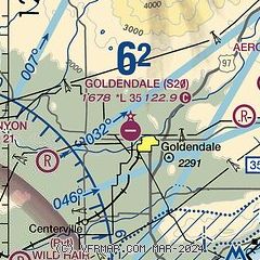
| Sectional chart |
|---|
|
| Airport distance calculator |
|---|
|
|
| Sunrise and sunset |
|---|
|
Times for 05-Feb-2026
| | Local
(UTC-8) | | Zulu
(UTC) |
|---|
| Morning civil twilight | | 06:50 | | 14:50 |
| Sunrise | | 07:21 | | 15:21 |
| Sunset | | 17:14 | | 01:14 |
| Evening civil twilight | | 17:45 | | 01:45 |
|
| Current date and time |
|---|
| Zulu (UTC) | 05-Feb-2026 17:17:46 |
|---|
| Local (UTC-8) | 05-Feb-2026 09:17:46 |
|---|
|
| METAR |
|---|
KDLS
19nm SW | 051653Z AUTO 00000KT 10SM OVC023 07/06 A3038 RMK AO2 SLP288 T00670056
|
K4S2
30nm W | 051655Z AUTO 06006KT 030V090 10SM BKN012 OVC018 06/03 A3036 RMK AO2
|
|
| TAF |
|---|
KDLS
19nm SW | 051403Z 0514/0612 10003KT 6SM BR OVC020 FM051900 09004KT P6SM OVC015 FM052300 VRB06KT P6SM BKN250
|
|
| NOTAMs |
|---|
NOTAMs are issued by the DoD/FAA and will open in a separate window not controlled by AirNav.
|
|

