FAA INFORMATION EFFECTIVE 16 APRIL 2026
Location
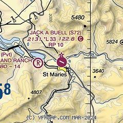
| FAA Identifier: | S72 |
| Lat/Long: | 47-19-32.9200N 116-34-36.0400W
47-19.548667N 116-34.600667W
47.3258111,-116.5766778
(estimated) |
| Elevation: | 2131.3 ft. / 649.6 m (surveyed) |
| Variation: | 15E (2010) |
| From city: | 1 mile NW of ST MARIES, ID |
| Time zone: | UTC -7 (UTC -8 during Standard Time) |
| Zip code: | 83861 |
Airport Operations
| Airport use: | Open to the public |
| Activation date: | 04/1940 |
| Control tower: | no |
| ARTCC: | SEATTLE CENTER |
| FSS: | BOISE FLIGHT SERVICE STATION |
| NOTAMs facility: | BOI (NOTAM-D service available) |
| Attendance: | UNATNDD |
| Wind indicator: | lighted |
| Segmented circle: | yes |
| Lights: | ACTVT MIRL RWY 10/28 - CTAF. |
| Beacon: | white-green (lighted land airport)
Operates sunset to sunrise. |
Airport Communications
Nearby radio navigation aids
| VOR radial/distance | | VOR name | | Freq | | Var |
|---|
| COEr141/28.6 | | COEUR D'ALENE VOR/DME | | 108.80 | | 19E |
| MLPr243/38.6 | | MULLAN PASS VOR/DME | | 117.80 | | 15E |
Airport Services
| Fuel available: | 100LL |
| Parking: | tiedowns |
| Airframe service: | MINOR |
| Powerplant service: | MINOR |
| Bottled oxygen: | NONE |
| Bulk oxygen: | NONE |
Runway Information
Runway 10/28
| Dimensions: | 3354 x 60 ft. / 1022 x 18 m |
| Surface: | asphalt, in excellent condition |
| Weight bearing capacity: | |
| Runway edge lights: | medium intensity
FIRST 715 FT RWY 10 NOT LGTD. |
| Runway edge markings: | NSTD DSPLCD THLD MARKING YELLOW CHEVRONS. |
| RUNWAY 10 | | RUNWAY 28 |
| Latitude: | 47-19.666000N | | 47-19.431333N |
| Longitude: | 116-34.967833W | | 116-34.233500W |
| Elevation: | 2131.3 ft. | | 2126.3 ft. |
| Traffic pattern: | right | | left |
| Runway heading: | 100 magnetic, 115 true | | 280 magnetic, 295 true |
| Markings: | basic, in good condition | | basic, in good condition |
| Runway end identifier lights: | no | | |
| Touchdown point: | yes, no lights | | yes, no lights |
| Obstructions: | 35 ft. road, 825 ft. from runway, 17:1 slope to clear
DSPLCD FOR 35 FT ROAD AT 0 FT; 30 FT RIGHT; 23:1 FM DSPLCD THLD. | | 45 ft. trees, 1700 ft. from runway, 33:1 slope to clear
ADDNL OBSTNS +50' PLINE AT 2000', ON CNTRLN +4' FENCE AT 275' ON CNTRLN, +1000' RIDGE AT 1 1/2 MILES, ON CNTRLN. |
Airport Ownership and Management from official FAA records
| Ownership: | Publicly-owned |
| Owner: | BENEWAH COUNTY
BENEWAH COUNTY COURTHOUSE
ST MARIES, ID 83861
Phone 208-245-2234 |
| Manager: | JIM ROLETTO
701 COLLEGE AVE
ST MARIES, ID 83861
Phone 208-967-4232 |
Additional Remarks
| - | RY 28 HAS 200 FT STOPWAY. |
| - | FOR CD CTC SEATTLE ARTCC AT 253-351-3694. |
Instrument Procedures
There are no published instrument procedures at S72.
Some nearby airports with instrument procedures:
KCOE - Coeur d'Alene Airport - Pappy Boyington Field (29 nm N)
KSFF - Felts Field Airport (37 nm NW)
KPUW - Pullman/Moscow Regional Airport (41 nm SW)
KGEG - Spokane International Airport (43 nm NW)
KSKA - Fairchild Air Force Base (47 nm W)
|
|

Road maps at:
MapQuest
Bing
Google
| Aerial photo |
|---|
WARNING: Photo may not be current or correct
 Photo by Colin FitzGerald
Photo taken 26-Nov-2011
looking east.
Photo by Colin FitzGerald
Photo taken 26-Nov-2011
looking east.
Do you have a better or more recent aerial photo of Jack A Buell Airport that you would like to share? If so, please send us your photo.
|
| Sectional chart |
|---|
|
| Airport distance calculator |
|---|
|
|
| Sunrise and sunset |
|---|
|
Times for 02-May-2026
| | Local
(UTC-7) | | Zulu
(UTC) |
|---|
| Morning civil twilight | | 04:55 | | 11:55 |
| Sunrise | | 05:29 | | 12:29 |
| Sunset | | 19:58 | | 02:58 |
| Evening civil twilight | | 20:32 | | 03:32 |
|
| Current date and time |
|---|
| Zulu (UTC) | 03-May-2026 01:29:36 |
|---|
| Local (UTC-7) | 02-May-2026 18:29:36 |
|---|
|
| METAR |
|---|
KCOE
28nm N | 030056Z AUTO 00000KT 10SM CLR 25/01 A2994 RMK AO2 SLP145 T02500011 PNO $
|
KSFF
37nm NW | 030053Z VRB05KT 10SM CLR 25/01 A2992 RMK AO2 SLP125 T02500011
|
KMLP
38nm E | 030053Z AUTO 36005KT 10SM BKN075 OVC100 13/M04 A3007 RMK AO2 SLP109 T01331039
|
KPUW
41nm SW | 030053Z AUTO 33005KT 10SM CLR 22/07 A2995 RMK AO2 SLP135 T02170067
|
KGEG
43nm NW | 030053Z 34004KT 10SM FEW085 FEW150 BKN250 25/M01 A2994 RMK AO2 SLP126 VIRGA T02501006
|
KSKA
47nm W | 030055Z AUTO 32004KT 10SM CLR 25/01 A2994 RMK AO2 SLP128 T02480010 $
|
|
| TAF |
|---|
KCOE
28nm N | 021720Z 0218/0318 03009KT P6SM SCT150 BKN250 FM022000 VRB06KT P6SM SCT120 BKN200 FM030600 06005KT P6SM SCT120 BKN200
|
|
| NOTAMs |
|---|
NOTAMs are issued by the DoD/FAA and will open in a separate window not controlled by AirNav.
|
|

