FAA INFORMATION EFFECTIVE 09 JULY 2026
Location
| FAA Identifier: | SGH |
| Lat/Long: | 39-50-25.0000N 083-50-24.6000W
39-50.416667N 083-50.410000W
39.8402778,-83.8401667
(estimated) |
| Elevation: | 1051.3 ft. / 320.4 m (surveyed) |
| Variation: | 04W (1985) |
| From city: | 5 miles SSW of SPRINGFIELD, OH |
| Time zone: | UTC -4 (UTC -5 during Standard Time) |
| Zip code: | 45502 |
Airport Operations
| Airport use: | Open to the public |
| Activation date: | 11/1947 |
| Control tower: | no |
| ARTCC: | INDIANAPOLIS CENTER |
| FSS: | DAYTON FLIGHT SERVICE STATION |
| NOTAMs facility: | SGH (NOTAM-D service available) |
| Attendance: | MON-FRI 0730-1600 |
| Pattern altitude: | 2100.3 ft. MSL
OHD TPA 1549 FT AGL. |
| Wind indicator: | lighted |
| Segmented circle: | no |
| Lights: | ACTVT WIND CONE; SSALR RWY 24; REIL RWY 06, 15, & 33; HIRL RWY 06/24; MIRL RWY 15/33 - CTAF. PAPI RWY 06, 24, 15, & 33 OPR CONSLY. |
| Beacon: | white-green (lighted land airport)
Operates sunset to sunrise. |
Airport Communications
| CTAF/UNICOM: | 122.95 |
| WX AWOS-3PT: | 134.975 (937-324-4532) |
| COLUMBUS APPROACH: | 118.85 |
| COLUMBUS DEPARTURE: | 118.85 |
| DANEI STAR: | 134.45 |
| WX AWOS-3 at GDK (11 nm SW): | 118.525 (937-372-4668) |
| WX ASOS at DAY (18 nm W): | PHONE 937-419-1421 |
| WX AWOS-3 at I74 (18 nm N): | 118.325 (937-484-5863) |
| WX AWOS-3PT at UYF (18 nm E): | 120.85 (740-852-2844) |
Nearby radio navigation aids
| VOR radial/distance | | VOR name | | Freq | | Var |
|---|
| MXQr360/24.7 | | MIDWEST VOR/DME | | 112.90 | | 04W |
| DQNr113/27.7 | | DAYTON VOR/DME | | 114.50 | | 01W |
| RODr166/28.4 | | ROSEWOOD VORTAC | | 117.50 | | 05W |
| NDB name | | Hdg/Dist | | Freq | | Var | | ID |
|---|
| COURT HOUSE | | 311/25.2 | | 414 | | 06W | | CSS | -.-. ... ... |
Airport Services
| Fuel available: | 100LL JET-A+ |
| Parking: | hangars and tiedowns |
| Airframe service: | MAJOR |
| Powerplant service: | MAJOR |
| Bottled oxygen: | LOW |
| Bulk oxygen: | HIGH |
Runway Information
Runway 6/24
| Dimensions: | 9010 x 150 ft. / 2746 x 46 m |
| Surface: | asphalt/concrete/grooved, in fair condition
NE 980 FT CONC, SW 1200 FT CONC, 6830 FT ASPH BTN. |
| Weight bearing capacity: | | PCN 60 /R/B/W/T | | Single wheel: | 66.0 | | Double wheel: | 175.0 | | Double tandem: | 330.0 |
|
| Runway edge lights: | high intensity |
| RUNWAY 6 | | RUNWAY 24 |
| Latitude: | 39-50.103985N | | 39-50.972342N |
| Longitude: | 083-51.083613W | | 083-49.522532W |
| Elevation: | 1051.3 ft. | | 1036.9 ft. |
| Traffic pattern: | left | | left |
| Runway heading: | 058 magnetic, 054 true | | 238 magnetic, 234 true |
| Declared distances: | TORA:9009 TODA:9009 ASDA:9009 LDA:9009 | | TORA:9009 TODA:9009 ASDA:9009 LDA:9009 |
| Markings: | precision, in good condition | | precision, in good condition |
| Visual slope indicator: | 4-light PAPI on left (3.00 degrees glide path) | | 4-light PAPI on left (3.00 degrees glide path) |
| Approach lights: | | | SSALR: simplified short approach lighting system with runway alignment indicator lights
ALS UNMON INDEFLY. |
| Runway end identifier lights: | yes | | |
| Touchdown point: | yes, no lights | | yes, no lights |
| Instrument approach: | | | LOC/GS |
| Obstructions: | 58 ft. trees, 1697 ft. from runway, 161 ft. left of centerline, 25:1 slope to clear | | 70 ft. tree, 1939 ft. from runway, 462 ft. right of centerline, 24:1 slope to clear |
Runway 15/33
| Dimensions: | 5498 x 100 ft. / 1676 x 30 m |
| Surface: | asphalt, in excellent condition |
| Weight bearing capacity: | | Single wheel: | 35.0 | | Double wheel: | 50.0 |
|
| Runway edge lights: | medium intensity |
| RUNWAY 15 | | RUNWAY 33 |
| Latitude: | 39-50.586653N | | 39-49.852273N |
| Longitude: | 083-50.927763W | | 083-50.240408W |
| Elevation: | 1042.1 ft. | | 1041.3 ft. |
| Traffic pattern: | left | | left |
| Runway heading: | 148 magnetic, 144 true | | 328 magnetic, 324 true |
| Declared distances: | TORA:5499 TODA:5499 ASDA:5499 LDA:5499 | | TORA:5499 TODA:5499 ASDA:5499 LDA:5499 |
| Markings: | nonprecision, in good condition | | nonprecision, in good condition |
| Visual slope indicator: | 4-light PAPI on left (3.00 degrees glide path)
PAPI UNUSBL BYD 9 DEGS RIGHT OF CNTRLN. | | 4-light PAPI on left (3.00 degrees glide path) |
| Runway end identifier lights: | yes | | yes |
| Touchdown point: | yes, no lights | | yes, no lights |
| Obstructions: | 7 ft. crops, 287 ft. from runway, 131 ft. right of centerline, 12:1 slope to clear | | 55 ft. trees, 1450 ft. from runway, 154 ft. right of centerline, 22:1 slope to clear |
Airport Ownership and Management from official FAA records
| Ownership: | Publicly-owned |
| Owner: | CITY OF SPRINGFIELD
76 E HIGH ST
SPRINGFIELD, OH 45502-1214
Phone 937-325-6108 |
| Manager: | DRAKE HUFFMAN
1251 W BLEE RD
SPRINGFIELD, OH 45502-8729
Phone 937-325-6108
OR 937-323-5804. |
Additional Remarks
| A30A-24 | CALM WIND RWY. |
| - | NOISE ABATEMENT: AVOID OVERFLYING YELLOW SPRINGS 2 NM SW BLW 4000 FT. |
| - | AVOID OVERFLYING ANG RAMP. |
| - | FOR CD CTC COLUMBUS APCH AT 614-338-8537. |
| - | OCNL DEER, BIRDS, & OTR WILDLIFE ON & INVOF ARPT. |
| - | HVY BIRD ACT DRG FALL & WINTER MONTHS. |
Instrument Procedures
NOTE: All procedures below are presented as PDF files. If you need a reader for these files, you should download the free Adobe Reader.NOT FOR NAVIGATION. Please procure official charts for flight.
FAA instrument procedures published for use from 09 July 2026 at 0901Z to 06 August 2026 at 0900Z.
STARs - Standard Terminal Arrivals |
|---|
| DANEI THREE **NEW** | |
download (157KB) |
IAPs - Instrument Approach Procedures |
|---|
| RNAV (GPS) RWY 06 | |
download (234KB) |
| RNAV (GPS) RWY 15 | |
download (218KB) |
| RNAV (GPS) RWY 24 | |
download (249KB) |
| RNAV (GPS) RWY 33 | |
download (224KB) |
| NOTE: Special Alternate Minimums apply | |
download (144KB) |
| NOTE: Special Take-Off Minimums/Departure Procedures apply | |
download (462KB) |
Other nearby airports with instrument procedures:
KFFO - Wright-Patterson Air Force Base (10 nm W)
KGDK - Greene County/Lewis A Jackson Regional Airport (11 nm SW)
KDAY - James M Cox Dayton International Airport (18 nm W)
I74 - Grimes Field Airport (18 nm N)
KUYF - Madison County Airport (18 nm E)
|
|

Road maps at:
MapQuest
Bing
Google
| Aerial photo |
|---|
WARNING: Photo may not be current or correct

Do you have a better or more recent aerial photo of Springfield/Beckley Municipal Airport that you would like to share? If so, please send us your photo.
|
| Sectional chart |
|---|
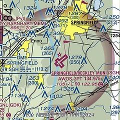
|
 Download PDF
of official airport diagram from the FAA
| Airport distance calculator |
|---|
|
|
| Sunrise and sunset |
|---|
|
Times for 25-Jul-2026
| | Local
(UTC-4) | | Zulu
(UTC) |
|---|
| Morning civil twilight | | 05:58 | | 09:58 |
| Sunrise | | 06:29 | | 10:29 |
| Sunset | | 20:55 | | 00:55 |
| Evening civil twilight | | 21:26 | | 01:26 |
|
| Current date and time |
|---|
| Zulu (UTC) | 25-Jul-2026 22:51:08 |
|---|
| Local (UTC-4) | 25-Jul-2026 18:51:08 |
|---|
|
| METAR |
|---|
KSGH
2nm SE | 252156Z AUTO 26006KT 10SM BKN050 27/16 A3001 RMK AO2 SLP157 T02720161
|
KFFO
9nm W | 252155Z AUTO 26006KT 10SM SCT065 28/16 A2998 RMK AO2 SLP151 T02750155
|
KDAY
18nm W | 252156Z 25007KT 10SM FEW040 BKN060 BKN110 26/16 A3001 RMK AO2 SLP154 T02560161 $
|
KI74
18nm N | 252235Z AUTO 27003KT 10SM SCT043 SCT120 26/17 A3001 RMK AO2
|
KUYF
18nm E | 252235Z AUTO 18003KT 10SM SCT050 BKN120 26/17 A3001 RMK AO2
|
|
| TAF |
|---|
KFFO
9nm W | 251900Z 2519/2701 24009KT 9999 VCSH SCT030 BKN060 QNH2995INS BECMG 2522/2523 27009KT 9999 NSW SCT025 BKN040 BKN060 QNH2995INS BECMG 2601/2603 27006KT 9999 BKN025 BKN040 QNH2994INS BECMG 2609/2611 27006KT 8000 BR FEW005 OVC015 QNH2995INS BECMG 2612/2614 29009KT 9999 NSW SCT025 BKN040 QNH2986INS BECMG 2623/2624 24009KT 9999 VCSH SCT030 BKN060 BKN200 QNH2986INS TX30/2619Z TN21/2611Z
|
KDAY
18nm W | 251730Z 2518/2618 25006KT P6SM FEW250 FM260200 VRB05KT P6SM SCT060 FM261200 VRB05KT P6SM BKN027 FM261500 28003KT P6SM BKN015 FM261700 27004KT P6SM BKN027
|
|
| NOTAMs |
|---|
NOTAMs are issued by the DoD/FAA and will open in a separate window not controlled by AirNav.
|
|


