FAA INFORMATION EFFECTIVE 09 JULY 2026
Location
| FAA Identifier: | I74 |
| Lat/Long: | 40-07-56.5387N 083-45-14.6258W
40-07.942312N 083-45.243763W
40.1323719,-83.7540627
(estimated) |
| Elevation: | 1067.9 ft. / 325.5 m (surveyed) |
| Variation: | 04W (1985) |
| From city: | 1 mile N of URBANA, OH |
| Time zone: | UTC -4 (UTC -5 during Standard Time) |
| Zip code: | 43078 |
Airport Operations
| Airport use: | Open to the public |
| Activation date: | 07/1942 |
| Control tower: | no |
| ARTCC: | INDIANAPOLIS CENTER |
| FSS: | DAYTON FLIGHT SERVICE STATION |
| NOTAMs facility: | I74 (NOTAM-D service available) |
| Attendance: | MON-FRI 0800-1600
UNATNDD MAJOR HOLS. |
| Wind indicator: | lighted |
| Segmented circle: | no |
| Lights: | ACTVT REIL RWY 02 & 20; MIRL RWY 02/20 - CTAF. |
| Beacon: | white-green (lighted land airport)
Operates sunset to sunrise. |
| Landing fee: | yes, LDG FEE FOR ACFT WITH MAX LDG WT 6000 LB OR GTR - WAIVED WITH MNM FUEL PURCHASE. |
Airport Communications
| CTAF/UNICOM: | 122.7 |
| WX AWOS-3: | 118.325 (937-484-5863) |
| COLUMBUS APPROACH: | 134.45 |
| COLUMBUS DEPARTURE: | 134.45 |
| WX AWOS-3 at EDJ (15 nm N): | 118.075 (937-599-4654) |
| WX AWOS-3PT at SGH (18 nm S): | 134.975 (937-324-4532) |
| WX AWOS-3PT at UYF (18 nm SE): | 120.85 (740-852-2844) |
| WX AWOS-3 at SCA (19 nm W): | 120.425 (937-492-3683) |
| WX AWOS-3PT at MRT (19 nm E): | 126.5 (937-553-0033) |
Nearby radio navigation aids
| VOR radial/distance | | VOR name | | Freq | | Var |
|---|
| RODr130/16.2 | | ROSEWOOD VORTAC | | 117.50 | | 05W |
| DQNr078/30.3 | | DAYTON VOR/DME | | 114.50 | | 01W |
| NDB name | | Hdg/Dist | | Freq | | Var | | ID |
|---|
| COURT HOUSE | | 338/36.0 | | 414 | | 06W | | CSS | -.-. ... ... |
Airport Services
| Fuel available: | 100LL JET-A+
100LL:100LL & JET A+ AVBL H24 SELF SVC VIA CREDIT CARD. |
| Parking: | hangars and tiedowns |
| Airframe service: | MINOR |
| Powerplant service: | MINOR |
| Bottled oxygen: | NONE |
| Bulk oxygen: | NONE |
Runway Information
Runway 2/20
| Dimensions: | 4400 x 100 ft. / 1341 x 30 m |
| Surface: | asphalt, in fair condition |
| Runway edge lights: | medium intensity |
| RUNWAY 2 | | RUNWAY 20 |
| Latitude: | 40-07.609412N | | 40-08.299047N |
| Longitude: | 083-45.357170W | | 083-45.067192W |
| Elevation: | 1057.8 ft. | | 1067.5 ft. |
| Traffic pattern: | left | | left |
| Runway heading: | 022 magnetic, 018 true | | 202 magnetic, 198 true |
| Markings: | nonprecision, in fair condition | | nonprecision, in fair condition |
| Visual slope indicator: | 4-light PAPI on right (3.00 degrees glide path) | | 4-light PAPI on left (3.00 degrees glide path) |
| Runway end identifier lights: | yes | | yes |
| Touchdown point: | yes, no lights | | yes, no lights |
Runway 1/19
| Dimensions: | 3000 x 100 ft. / 914 x 30 m |
| Surface: | turf, in good condition |
| Runway edge markings: | YELLOW CONES. |
| RUNWAY 1 | | RUNWAY 19 |
| Latitude: | 40-07.680167N | | 40-08.169500N |
| Longitude: | 083-45.334333W | | 083-45.245833W |
| Elevation: | 1060.0 ft. | | 1060.0 ft. |
| Traffic pattern: | left | | left |
| Runway heading: | 012 magnetic, 008 true | | 192 magnetic, 188 true |
| Markings: | , in good condition | | , in good condition |
Airport Ownership and Management from official FAA records
| Ownership: | Publicly-owned |
| Owner: | CITY OF URBANA
205 S MAIN ST
URBANA, OH 43078-2113
Phone 937-652-4304 |
| Manager: | DRAKE HUFFMAN
1636 N MAIN ST
URBANA, OH 43078-5001
Phone 937-652-4319
CELL 740-995-9919. |
Additional Remarks
| A30A-20 | CALM WIND RWY. |
| - | FOR CD CTC COLUMBUS APCH AT 614-338-8537. |
| - | BIRDS & DEER ON & INVOF ARPT. |
| - | 125 FT WATER TWR, 1 NM SOUTH. |
Instrument Procedures
NOTE: All procedures below are presented as PDF files. If you need a reader for these files, you should download the free Adobe Reader.NOT FOR NAVIGATION. Please procure official charts for flight.
FAA instrument procedures published for use from 09 July 2026 at 0901Z to 06 August 2026 at 0900Z.
IAPs - Instrument Approach Procedures |
|---|
| RNAV (GPS) RWY 02 | |
download (238KB) |
| RNAV (GPS) RWY 20 | |
download (256KB) |
| NOTE: Special Alternate Minimums apply | |
download (151KB) |
| NOTE: Special Take-Off Minimums/Departure Procedures apply | |
download (474KB) |
Other nearby airports with instrument procedures:
KEDJ - Bellefontaine Regional Airport (15 nm N)
KSGH - Springfield/Beckley Municipal Airport (18 nm S)
KUYF - Madison County Airport (18 nm SE)
KSCA - Sidney Municipal Airport (19 nm W)
KMRT - Union County Airport (19 nm E)
|
|

Road maps at:
MapQuest
Bing
Google
| Aerial photo |
|---|
WARNING: Photo may not be current or correct
 Photo by Michael Armstrong
Photo taken 11-Oct-2013
looking west.
Photo by Michael Armstrong
Photo taken 11-Oct-2013
looking west.
Do you have a better or more recent aerial photo of Grimes Field Airport that you would like to share? If so, please send us your photo.
|
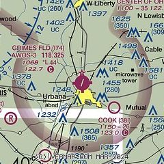
| Sectional chart |
|---|
|
CAUTION: Diagram may not be current

| Airport distance calculator |
|---|
|
|
| Sunrise and sunset |
|---|
|
Times for 02-Aug-2026
| | Local
(UTC-4) | | Zulu
(UTC) |
|---|
| Morning civil twilight | | 06:05 | | 10:05 |
| Sunrise | | 06:35 | | 10:35 |
| Sunset | | 20:48 | | 00:48 |
| Evening civil twilight | | 21:18 | | 01:18 |
|
| Current date and time |
|---|
| Zulu (UTC) | 03-Aug-2026 00:21:18 |
|---|
| Local (UTC-4) | 02-Aug-2026 20:21:18 |
|---|
|
| METAR |
|---|
| KI74 | 022355Z AUTO 01005KT 7SM SCT014 OVC024 20/19 A2979 RMK AO2
|
KEDJ
15nm N | 022355Z AUTO 03009G14KT 10SM BKN016 BKN024 OVC030 21/20 A2981 RMK A01
|
KUYF
18nm SE | 022355Z AUTO 01009KT 7SM OVC013 21/20 A2979 RMK AO2
|
KSGH
19nm S | 022356Z AUTO 36010KT 3SM -RA BR OVC007 20/19 A2979 RMK AO2 RAB08 CIG 005V009 SLP084 P0000 60030 T02000194 10244 20200 53009
|
KMRT
19nm E | 022355Z AUTO 35006KT 10SM OVC011 21/21 A2978 RMK AO2 10252 20212
|
|
| TAF |
|---|
KFFO
23nm SW | 021900Z 0219/0401 33009KT 9999 VCSH SCT015 BKN045 510102 QNH2970INS WND 270V020 TEMPO 0219/0223 31012G18KT 3200 -SHRA BR BKN015 OVC035 BECMG 0222/0223 32009KT 9999 NSW BKN040 QNH2972INS BECMG 0301/0303 35009KT 9999 MIFG BKN015 OVC025 QNH2980INS TEMPO 0310/0314 9000 BR OVC009 BECMG 0312/0314 02009KT 9999 NSW SCT015 BKN025 QNH2993INS BECMG 0315/0316 03012KT 9999 FEW025 QNH2994INS WND VRB06KT AFT 0323 TX27/0319Z TN18/0311Z
|
KDAY
25nm SW | 021730Z 0218/0318 28005KT P6SM -SHRA BKN025 FM030100 01008KT P6SM OVC050 FM031000 36007KT P6SM BKN025 FM031100 36007KT P6SM OVC008 FM031300 36007KT P6SM BKN015 OVC025 FM031600 02008KT P6SM BKN040
|
|
| NOTAMs |
|---|
NOTAMs are issued by the DoD/FAA and will open in a separate window not controlled by AirNav.
|
|


