FAA INFORMATION EFFECTIVE 09 JULY 2026
Location
| FAA Identifier: | WVI |
| Lat/Long: | 36-56-08.6370N 121-47-22.6950W
36-56.143950N 121-47.378250W
36.9357325,-121.7896375
(estimated) |
| Elevation: | 163.3 ft. / 49.8 m (surveyed) |
| Variation: | 14E (2015) |
| From city: | 3 miles NW of WATSONVILLE, CA |
| Time zone: | UTC -7 (UTC -8 during Standard Time) |
| Zip code: | 95076 |
Airport Operations
| Airport use: | Open to the public |
| Control tower: | no |
| ARTCC: | OAKLAND CENTER |
| FSS: | OAKLAND FLIGHT SERVICE STATION |
| NOTAMs facility: | WVI (NOTAM-D service available) |
| Attendance: | 0900-1700 |
| Wind indicator: | lighted |
| Segmented circle: | yes |
| Lights: | ACTVT PAPI RWY 02, 09 & 20; REIL RWY 02; MIRL RWY 02/20 - CTAF. |
| Beacon: | white-green (lighted land airport)
Operates sunset to sunrise. |
Airport Communications
| CTAF/UNICOM: | 122.8 |
| WX ASOS: | 132.275 (831-724-8794) |
| NORCAL APPROACH: | 127.15 ;136-360 MRY |
| NORCAL DEPARTURE: | 127.15 ;136-360 MRY |
| CLASS C: | 127.15 ;136-360 MRY |
| IC: | 127.15 ;136-360 MRY |
| WX AWOS-3P at E16 (13 nm NE): | 118.350 (408-918-7724) |
| WX AWOS-3PT at OAR (15 nm S): | 134.025 (831-384-2967) |
| WX AWOS-3 at CVH (18 nm E): | 120.425 (831-636-4394) |
| WX ASOS at SNS (19 nm SE): | PHONE 831-422-2830 |
Nearby radio navigation aids
| VOR radial/distance | | VOR name | | Freq | | Var |
|---|
| SNSr314/18.6 | | SALINAS VORTAC | | 117.30 | | 17E |
| SJCr148/27.4 | | SAN JOSE VOR/DME | | 114.10 | | 16E |
| OSIr122/36.1 | | WOODSIDE VOR/DME | | 113.90 | | 17E |
Airport Services
| Fuel available: | 100LL JET-A G100 |
| Parking: | tiedowns |
| Airframe service: | MINOR |
| Powerplant service: | MAJOR |
| Bottled oxygen: | LOW |
| Bulk oxygen: | NONE |
Runway Information
Runway 2/20
| Dimensions: | 4502 x 149 ft. / 1372 x 45 m |
| Surface: | asphalt, in fair condition |
| Weight bearing capacity: | | Single wheel: | 81.0 | | Double wheel: | 96.0 | | Double tandem: | 167.0 |
|
| Runway edge lights: | medium intensity |
| RUNWAY 2 | | RUNWAY 20 |
| Latitude: | 36-55.742077N | | 36-56.368937N |
| Longitude: | 121-47.748047W | | 121-47.253890W |
| Elevation: | 139.5 ft. | | 157.7 ft. |
| Traffic pattern: | left | | left |
| Runway heading: | 018 magnetic, 032 true | | 198 magnetic, 212 true |
| Displaced threshold: | no | | 589 ft. |
| Markings: | nonprecision, in fair condition | | nonprecision, in fair condition |
| Visual slope indicator: | 2-light PAPI on left (3.00 degrees glide path) | | 2-light PAPI on left (3.00 degrees glide path)
UNUSBL BYD 4.0 NM DUE TO TERRAIN. |
| Runway end identifier lights: | yes | | no |
| Touchdown point: | yes, no lights | | yes, no lights |
| Instrument approach: | LOCALIZER | | |
| Obstructions: | 46 ft. trees, 1310 ft. from runway, 39 ft. left of centerline, 24:1 slope to clear | | 80 ft. tree, 1198 ft. from runway, 125 ft. left of centerline, 12:1 slope to clear
RWY 20 APCH RATIO 22:1 TO DSPLCD THR. |
Runway 9/27
| Dimensions: | 3998 x 98 ft. / 1219 x 30 m |
| Surface: | asphalt, in fair condition |
| Weight bearing capacity: | | Single wheel: | 45.0 | | Double wheel: | 65.0 |
|
| RUNWAY 9 | | RUNWAY 27 |
| Latitude: | 36-56.299728N | | 36-56.187265N |
| Longitude: | 121-47.644432W | | 121-46.835682W |
| Elevation: | 163.3 ft. | | 136.3 ft. |
| Traffic pattern: | left | | left |
| Runway heading: | 086 magnetic, 100 true | | 266 magnetic, 280 true |
| Markings: | basic, in fair condition | | basic, in fair condition |
| Visual slope indicator: | 2-light PAPI on right (4.00 degrees glide path) | | |
| Runway end identifier lights: | no | | no |
| Touchdown point: | yes, no lights | | yes, no lights |
| Obstructions: | 38 ft. tree, 1050 ft. from runway, 22:1 slope to clear | | 55 ft. tree, 935 ft. from runway, 40 ft. right of centerline, 13:1 slope to clear |
Helipad H2
| Dimensions: | 40 x 40 ft. / 12 x 12 m |
| Surface: | asphalt |
| Latitude: | 36-56.134500N | | |
| Longitude: | 121-47.338833W | | |
| Elevation: | 148.0 ft. | | |
| Traffic pattern: | left | | left |
Helipad H1
| Dimensions: | 20 x 20 ft. / 6 x 6 m |
| Surface: | asphalt |
| Latitude: | 36-56.031833N | | |
| Longitude: | 121-47.411500W | | |
| Elevation: | 143.0 ft. | | |
| Traffic pattern: | left | | left |
Airport Ownership and Management from official FAA records
| Ownership: | Publicly-owned |
| Owner: | CITY OF WATSONVILLE
275 MAIN ST
WATSONVILLE, CA 95076
Phone 831-768-3575 |
| Manager: | RAYVON WILLIAMS
100 AVIATION WAY
WATSONVILLE, CA 95076
Phone 831-768-3575
RAYVON.WILLIAMS@CITYOFWATSONVILLE.ORG |
Additional Remarks
| - | SEAGULLS ON & INVOF ARPT. |
| - | FOR CD CTC NORCAL APCH AT 916-361-3748 OR VIA VHF 127.15. |
| - | ALL DEPS PROHIBITED ON RWY 27 DUE TO RWY VIS BLOCKED BY HNGRS. |
| - | 130 FT TREES 700 FT RIGHT OF RWY 9 THLD, 85 FT TREES 600 FT LEFT OF RWY 9 THLD. |
| - | ARPT HAS NOISE ABATEMENT PROCS; SEE ARPT WEBSITE. |
| - | RWY 20 PREF CALM WIND RWY; STRAIGHT-IN APCH NOT RCMDD. |
| - | GLIDER TOWING RQRS PRIOR NOTIFICATION, CTC ARPT OFC 831-768-3575. |
| - | HELICOPTER ACTVTY ON AND INVOF ARPT. |
| - | COASTAL FOG DURING SUMMER MONTHS. |
| - | PRCHT OPS ON ARPT DLY 0900-2000; LNDG AREA 1000 FT WEST OF RWY 20. |
Instrument Procedures
NOTE: All procedures below are presented as PDF files. If you need a reader for these files, you should download the free Adobe Reader.NOT FOR NAVIGATION. Please procure official charts for flight.
FAA instrument procedures published for use from 09 July 2026 at 0901Z to 06 August 2026 at 0900Z.
IAPs - Instrument Approach Procedures |
|---|
| RNAV (GPS) RWY 02 | |
download (245KB) |
| LOC RWY 02 | |
download (217KB) |
| VOR-A | |
download (181KB) |
| NOTE: Special Alternate Minimums apply | |
download (136KB) |
Departure Procedures |
|---|
| GARLK ONE (RNAV) | |
download (194KB) |
|
|---|
| WATSONVILLE FOUR (OBSTACLE) | |
download (436KB) |
| NOTE: Special Take-Off Minimums/Departure Procedures apply | |
download (246KB) |
Other nearby airports with instrument procedures:
E16 - San Martin Airport (13 nm NE)
KOAR - Marina Municipal Airport (15 nm S)
KCVH - Hollister Municipal Airport (18 nm E)
KSNS - Salinas Municipal Airport (19 nm SE)
KMRY - Monterey Regional Airport (21 nm S)
|
|

Road maps at:
MapQuest
Bing
Google
| Aerial photo |
|---|
WARNING: Photo may not be current or correct
 Photo by David Byrne of FocalFlight.com
Photo taken 06-Apr-2010
Photo by David Byrne of FocalFlight.com
Photo taken 06-Apr-2010
Do you have a better or more recent aerial photo of Watsonville Municipal Airport that you would like to share? If so, please send us your photo.
|
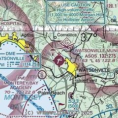
| Sectional chart |
|---|
|
CAUTION: Diagram may not be current

| Airport distance calculator |
|---|
|
|
| Sunrise and sunset |
|---|
|
Times for 21-Jul-2026
| | Local
(UTC-7) | | Zulu
(UTC) |
|---|
| Morning civil twilight | | 05:35 | | 12:35 |
| Sunrise | | 06:05 | | 13:05 |
| Sunset | | 20:22 | | 03:22 |
| Evening civil twilight | | 20:52 | | 03:52 |
|
| Current date and time |
|---|
| Zulu (UTC) | 21-Jul-2026 16:54:15 |
|---|
| Local (UTC-7) | 21-Jul-2026 09:54:15 |
|---|
|
| METAR |
|---|
| KWVI | 211553Z AUTO 16003KT 10SM CLR 22/13 A2997 RMK AO2 SLP146 T02170133
|
KE16
13nm NE | 211610Z AUTO 13008KT 9SM CLR 24/12 A2997 RMK AO2
|
KOAR
16nm S | 134.025 831-384-2967
211635Z AUTO 34007KT 10SM CLR 21/12 A2997 RMK AO2
|
KCVH
18nm E | 211635Z AUTO 00000KT 10SM CLR 26/09 A2996 RMK A01
|
KSNS
19nm SE | 211553Z 19004KT 10SM CLR 22/14 A2995 RMK AO2 SLP152 T02170139
|
|
| TAF |
|---|
KSNS
19nm SE | 211120Z 2112/2212 30007KT P6SM BKN150 FM220300 32006KT P6SM SCT010 BKN150
|
KMRY
21nm S | 211120Z 2112/2212 28007KT P6SM BKN150 FM220300 26003KT P6SM SCT010 BKN150
|
|
| NOTAMs |
|---|
NOTAMs are issued by the DoD/FAA and will open in a separate window not controlled by AirNav.
|
|


