FAA INFORMATION EFFECTIVE 17 APRIL 2025
Location
| FAA Identifier: | FTY |
| Lat/Long: | 33-46-44.8550N 084-31-16.9176W
33-46.747583N 084-31.281960W
33.7791264,-84.5213660
(estimated) |
| Elevation: | 841.1 ft. / 256.4 m (surveyed) |
| Variation: | 05W (2015) |
| From city: | 6 miles W of ATLANTA, GA |
| Time zone: | UTC -4 (UTC -5 during Standard Time) |
| Zip code: | 30336 |
Airport Operations
| Airport use: | Open to the public |
| Activation date: | 09/1949 |
| Control tower: | yes |
| ARTCC: | ATLANTA CENTER |
| FSS: | MACON FLIGHT SERVICE STATION |
| NOTAMs facility: | FTY (NOTAM-D service available) |
| Attendance: | CONTINUOUS |
| Wind indicator: | yes |
| Segmented circle: | yes |
| Lights: | SS-SR |
| Beacon: | white-green (lighted land airport)
Operates sunset to sunrise. |
| International operations: | customs landing rights airport |
Airport Communications
| UNICOM: | 122.95 |
| ATIS: | 120.175 |
| WX ASOS: | PHONE 404-696-5660 |
| FULTON COUNTY GROUND: | 121.7 348.6 |
| FULTON COUNTY TOWER: | 118.45 257.8 |
| ATLANTA APPROACH: | 121.0 |
| ATLANTA DEPARTURE: | 121.0 |
| BOKRT STAR: | 119.8 |
| OPS: | 141.35 |
| WRGNZ STAR: | 128.575 |
| WX ASOS at ATL (10 nm SE): | PHONE 404-559-5166 |
| WX ASOS at PDK (12 nm NE): | 128.4 (770-457-1691) |
| WX AWOS-3PT at RYY (15 nm N): | PHONE 770-425-3406 |
- EMERG FREQ 121.5 NOT AVBL.
Nearby radio navigation aids
| VOR radial/distance | | VOR name | | Freq | | Var |
|---|
| RMGr127/37.6 | | ROME VORTAC | | 115.40 | | 01E |
| NDB name | | Hdg/Dist | | Freq | | Var | | ID |
|---|
| PECAT | | 002/28.7 | | 316 | | 05W | | FFC | ..-. ..-. -.-. |
| COWETA COUNTY | | 020/32.8 | | 234 | | 03W | | EQQ | . --.- --.- |
| CARROLLTON | | 071/33.0 | | 278 | | 04W | | GPQ | --. .--. --.- |
Airport Services
| Fuel available: | 100LL JET-A+
100LL:FUEL SVC HILL AVN, C404-691-3330. |
| Parking: | hangars and tiedowns |
| Airframe service: | MAJOR |
| Powerplant service: | MAJOR |
| Bottled oxygen: | HIGH/LOW |
| Bulk oxygen: | HIGH/LOW |
Runway Information
Runway 8/26
| Dimensions: | 5797 x 100 ft. / 1767 x 30 m |
| Surface: | asphalt/grooved, in good condition |
| Weight bearing capacity: | | Single wheel: | 105.0 | | Double wheel: | 121.0 | | Double tandem: | 198.0 |
|
| Runway edge lights: | high intensity |
| RUNWAY 8 | | RUNWAY 26 |
| Latitude: | 33-46.721518N | | 33-46.892788N |
| Longitude: | 084-31.805498W | | 084-30.679403W |
| Elevation: | 799.9 ft. | | 814.1 ft. |
| Traffic pattern: | left | | right |
| Runway heading: | 085 magnetic, 080 true | | 265 magnetic, 260 true |
| Markings: | precision, in good condition | | precision, in good condition |
| Visual slope indicator: | | | 4-box VASI on left (3.00 degrees glide path) |
| Approach lights: | MALSR: 1,400 foot medium intensity approach lighting system with runway alignment indicator lights | | |
| Runway end identifier lights: | | | yes |
| Touchdown point: | yes, no lights | | yes, no lights |
| Instrument approach: | ILS | | |
| Obstructions: | 75 ft. trees, 1475 ft. from runway, 680 ft. right of centerline, 17:1 slope to clear | | 4 ft. trees, 276 ft. from runway, 509 ft. left of centerline, 19:1 slope to clear |
Runway 14/32
| Dimensions: | 4158 x 100 ft. / 1267 x 30 m |
| Surface: | asphalt, in fair condition |
| Weight bearing capacity: | |
| RUNWAY 14 | | RUNWAY 32 |
| Latitude: | 33-46.822025N | | 33-46.305870N |
| Longitude: | 084-31.735350W | | 084-31.195253W |
| Elevation: | 798.7 ft. | | 841.1 ft. |
| Traffic pattern: | left | | left |
| Runway heading: | 144 magnetic, 139 true | | 324 magnetic, 319 true |
| Displaced threshold: | no | | 200 ft. |
| Declared distances: | TORA:4158 TODA:4158 ASDA:4158 LDA:4158 | | TORA:4158 TODA:4158 |
| Markings: | basic, in fair condition | | basic, in fair condition |
| Runway end identifier lights: | no | | no |
| Touchdown point: | yes, no lights | | yes, no lights |
| Obstructions: | 43 ft. trees, 544 ft. from runway, 138 ft. right of centerline, 8:1 slope to clear | | 149 ft. trees, 1541 ft. from runway, 182 ft. right of centerline, 9:1 slope to clear
RWY 32 APCH RATIO 10:1 TO DSPLCD THLD. 154FT TREES 1540FT FROM DSPLCD THLD. |
Airport Ownership and Management from official FAA records
| Ownership: | Publicly-owned |
| Owner: | FULTON COUNTY
COUNTY COURTHOUSE, 141 PRYOR ST.
ATLANTA, GA 30303
Phone 404-699-4200 |
| Manager: | DAVID CLARK
141 PRYOR ST. SW
ATLANTA, GA 30303
Phone 404-612-2804 |
Additional Remarks
| - | FLOCKS OF BIRDS ON AND INVOF ARPT DURING DALGT HRS. |
| - | NOISE SENSITIVE AREA ALL QUADS; NO RUN UPS AUTH ON ANY RAMPS. |
| - | DEER AND OTHER WILDLIFE ON & INVOF ARPT. |
Instrument Procedures
NOTE: All procedures below are presented as PDF files. If you need a reader for these files, you should download the free Adobe Reader.NOT FOR NAVIGATION. Please procure official charts for flight.
FAA instrument procedures published for use from 17 April 2025 at 0901Z to 15 May 2025 at 0900z.
STARs - Standard Terminal Arrivals |
|---|
| BOKRT THREE (RNAV) | |
download (186KB) |
| BUKHD THREE (RNAV) | |
download (190KB) |
| DEHAN THREE (RNAV) | |
2 pages:
[1] [2] (326KB) |
| SWTEE TWO (RNAV) | |
download (142KB) |
| WRGNZ THREE (RNAV) | |
download (245KB) |
IAPs - Instrument Approach Procedures |
|---|
| ILS OR LOC RWY 08 | |
download (277KB) |
| RNAV (RNP) Z RWY 08 | |
download (192KB) |
| RNAV (GPS) RWY 26 | |
download (212KB) |
| RNAV (GPS) Y RWY 08 | |
download (261KB) |
| NOTE: Special Alternate Minimums apply | |
download (153KB) |
| NOTE: Special Take-Off Minimums/Departure Procedures apply | |
download (479KB) |
Other nearby airports with instrument procedures:
KMGE - Dobbins ARB Airport (8 nm N)
KATL - Hartsfield/Jackson Atlanta International Airport (10 nm SE)
KPDK - Dekalb-Peachtree Airport (12 nm NE)
KRYY - Cobb County International Airport-McCollum Field (15 nm N)
KPUJ - Paulding Northwest Atlanta Airport (22 nm W)
|
|

Road maps at:
MapQuest
Bing
Google
| Aerial photo |
|---|
WARNING: Photo may not be current or correct
 Photo by R. Winston Whitlock, Jr.
Photo taken 16-May-2010
Photo by R. Winston Whitlock, Jr.
Photo taken 16-May-2010
Do you have a better or more recent aerial photo of Fulton County Executive Airport/Charlie Brown Field that you would like to share? If so, please send us your photo.
|
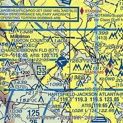
| Sectional chart |
|---|
|
CAUTION: Diagram may not be current
 Download PDF
of official airport diagram from the FAA
| Airport distance calculator |
|---|
|
|
| Sunrise and sunset |
|---|
|
Times for 03-May-2025
| | Local
(UTC-4) | | Zulu
(UTC) |
|---|
| Morning civil twilight | | 06:22 | | 10:22 |
| Sunrise | | 06:48 | | 10:48 |
| Sunset | | 20:22 | | 00:22 |
| Evening civil twilight | | 20:48 | | 00:48 |
|
| Current date and time |
|---|
| Zulu (UTC) | 03-May-2025 05:07:14 |
|---|
| Local (UTC-4) | 03-May-2025 01:07:14 |
|---|
|
| METAR |
|---|
| KFTY | 030453Z 00000KT 10SM CLR 16/16 A3000 RMK AO2 SLP152 T01610156 402890156
|
KMGE
8nm N | 030355Z AUTO 31003KT 10SM CLR 17/15 A3001 RMK AO2 SLP156 T01650148 $
|
KATL
9nm S | 030452Z 06005KT 10SM BKN120 18/15 A3001 RMK AO2 SLP154 T01780150 403000172 $
|
KPDK
13nm NE | 030453Z 00000KT 10SM CLR 16/15 A3001 RMK AO2 SLP150 T01560150 402830156
|
KRYY
15nm N | 030450Z AUTO VRB03KT 10SM FEW005 SCT110 16/15 A3002 RMK AO2 SLP167 T01610150 $
|
|
| TAF |
|---|
| KFTY | 022203Z 0222/0318 17010G18KT P6SM FEW060 FEW200 FM030000 19005KT P6SM VCSH BKN050 PROB30 0301/0305 3SM TSRA BR BKN025CB FM030500 27004KT P6SM SCT070 BKN200 FM031100 17006KT P6SM SCT015 BKN035 FM031500 19009KT 5SM SHRA BR SCT008 BKN015
|
KMGE
8nm N | 030030Z 0300/0403 21006KT 9999 SCT050 BKN080 QNH2988INS TEMPO 0301/0304 VRB15G25KT 4800 TSRAGR SCT015 BKN030CB BECMG 0305/0306 VRB05KT 9999 SCT030 BKN100 QNH2987INS BECMG 0312/0313 17009KT 9999 SCT020 BKN060 QNH2989INS BECMG 0316/0317 18010G15KT 6000 -SHRA VCTS BKN025CB OVC090 QNH2985INS BECMG 0318/0319 18015G20KT 4800 -TSRA BKN025CB OVC050 QNH2972INS BECMG 0400/0401 20010KT 9999 NSW SCT025 BKN080 QNH2971INS TX25/0301Z TN17/0312Z LAST NO AMDS AFT 0303 NEXT 0311
|
KATL
9nm S | 030349Z 0304/0406 19005KT P6SM VCSH BKN070 OVC100 FM031300 19007KT P6SM SCT015 BKN040 FM031500 20010G20KT 4SM SHRA BR SCT008 BKN015 FM031900 20010G22KT P6SM VCSH BKN008 OVC040 FM032300 23010KT P6SM SCT008 OVC040 PROB30 0323/0405 4SM TSRA BKN015CB
|
KPDK
13nm NE | 022205Z 0222/0318 19012G20KT P6SM FEW060 FEW200 FM030000 19005KT P6SM VCSH BKN050 PROB30 0301/0305 3SM TSRA BR BKN025CB FM030600 19004KT P6SM SCT080 BKN200 FM031200 17004KT P6SM SCT020 BKN040 FM031500 20009KT P6SM SCT009 BKN015
|
KRYY
15nm N | 021736Z 0218/0318 21008KT P6SM VCSH SCT040 TEMPO 0218/0222 4SM -TSRA BR BKN025CB FM030000 19006KT P6SM VCSH BKN050 PROB30 0300/0304 3SM TSRA BR BKN025CB FM030500 20008KT P6SM SCT060 BKN150 FM031100 17004KT P6SM SCT015 BKN040 FM031400 19008KT P6SM SCT008 BKN012
|
|
| NOTAMs |
|---|
NOTAMs are issued by the DoD/FAA and will open in a separate window not controlled by AirNav.
|
|


