FAA INFORMATION EFFECTIVE 14 MAY 2026
Location
| FAA Identifier: | AGC |
| Lat/Long: | 40-21-15.9755N 079-55-44.5680W
40-21.266258N 079-55.742800W
40.3544376,-79.9290467
(estimated) |
| Elevation: | 1251.5 ft. / 381.5 m (surveyed) |
| Variation: | 09W (2000) |
| From city: | 4 miles SE of PITTSBURGH, PA |
| Time zone: | UTC -4 (UTC -5 during Standard Time) |
| Zip code: | 15122 |
Airport Operations
| Airport use: | Open to the public |
| Activation date: | 11/1937 |
| Control tower: | yes |
| ARTCC: | CLEVELAND CENTER |
| FSS: | ALTOONA FLIGHT SERVICE STATION |
| NOTAMs facility: | AGC (NOTAM-D service available) |
| Attendance: | CONTINUOUS |
| Wind indicator: | lighted |
| Segmented circle: | no |
| Lights: | ATC-CTL. |
| Beacon: | white-green (lighted land airport)
Operates sunset to sunrise. |
| Landing fee: | yes, LNDG FEE FOR ACFT 5000 LBS & ABV TO INCL ALL HELS. |
Airport Communications
| UNICOM: | 122.95 |
| ATIS: | 120.55 |
| WX ASOS: | 120.55 (412-466-8968) |
| ALLEGHENY GROUND: | 121.7 |
| ALLEGHENY TOWER: | 121.1 239.0 |
| PITTSBURGH APPROACH: | 119.35 |
| PITTSBURGH DEPARTURE: | 119.35 |
| CLASS B: | 119.35 |
| WX AWOS-A at 42PN (7 nm NW): | PHONE 412-442-2213 |
| WX AWOS-3PT at FWQ (10 nm SE): | 118.475 (724-379-5815) |
| WX ASOS at PIT (16 nm NW): | PHONE 215-798-0218 |
Nearby radio navigation aids
| VOR radial/distance | | VOR name | | Freq | | Var |
|---|
| AGCr057/6.8 | | ALLEGHENY VOR/DME | | 110.00 | | 09W |
| HLGr086/29.8 | | WHEELING VOR/DME | | 114.25 | | 07W |
| EWCr163/31.0 | | ELLWOOD CITY VOR/DME | | 115.80 | | 08W |
Airport Services
| Fuel available: | 100LL JET-A JET-A+
A+:JET A ANTI-ICE AVBL ON REQ. |
| Parking: | hangars and tiedowns |
| Airframe service: | MAJOR |
| Powerplant service: | MAJOR |
| Bottled oxygen: | HIGH/LOW |
| Bulk oxygen: | HIGH/LOW |
Runway Information
Runway 10/28
| Dimensions: | 6501 x 150 ft. / 1982 x 46 m |
| Surface: | concrete/grooved, in good condition |
| Weight bearing capacity: | | Single wheel: | 90.0 | | Double wheel: | 120.0 | | Double tandem: | 210.0 |
|
| Runway edge lights: | high intensity |
| RUNWAY 10 | | RUNWAY 28 |
| Latitude: | 40-21.257053N | | 40-21.258655N |
| Longitude: | 079-56.465977W | | 079-55.066570W |
| Elevation: | 1249.4 ft. | | 1250.0 ft. |
| Traffic pattern: | left | | left |
| Runway heading: | 099 magnetic, 090 true | | 279 magnetic, 270 true |
| Markings: | precision, in good condition | | precision, in good condition |
| Visual slope indicator: | 4-box VASI on left (3.00 degrees glide path) | | |
| RVR equipment: | rollout | | touchdown |
| Approach lights: | | | MALS: 1,400 foot medium intensity approach lighting system |
| Runway end identifier lights: | yes | | |
| Touchdown point: | yes, no lights | | yes, no lights |
| Instrument approach: | ILS | | ILS |
| Obstructions: | none | | 64 ft. trees, 2613 ft. from runway, 433 ft. left of centerline, 37:1 slope to clear |
Runway 13/31
| Dimensions: | 3825 x 100 ft. / 1166 x 30 m |
| Surface: | concrete/grooved, in good condition |
| Weight bearing capacity: | | Single wheel: | 20.0 | | Double wheel: | 22.0 |
|
| Runway edge lights: | high intensity |
| RUNWAY 13 | | RUNWAY 31 |
| Latitude: | 40-21.437642N | | 40-21.123445N |
| Longitude: | 079-56.059787W | | 079-55.346018W |
| Elevation: | 1245.2 ft. | | 1248.6 ft. |
| Traffic pattern: | left | | left |
| Runway heading: | 129 magnetic, 120 true | | 309 magnetic, 300 true |
| Markings: | basic, in good condition | | basic, in good condition |
| Runway end identifier lights: | yes | | yes |
| Touchdown point: | yes, no lights | | yes, no lights |
| Obstructions: | none | | 11 ft. trees, 314 ft. from runway, 119 ft. right of centerline, 10:1 slope to clear |
Helipad H1
| Dimensions: | 47 x 45 ft. / 14 x 14 m |
| Surface: | concrete, in good condition |
| Operational restrictions: | HELIPAD LCTD ON GA APN E OF TWY C. |
| Latitude: | 40-21.191000N | | |
| Longitude: | 079-55.814333W | | |
| Elevation: | 1255.0 ft. | | |
| Traffic pattern: | left | | left |
| Markings: | basic, in good condition | | |
Airport Ownership and Management from official FAA records
| Ownership: | Publicly-owned |
| Owner: | ALLEGHENY CO ARPT AUTHORITY
PO BOX 12370
PITTSBURGH, PA 15231-0370
Phone 412-472-3500 |
| Manager: | LANCE BAGNOFF
12 ALLEGHENY COUNTY AIRPORT
WEST MIFFLIN, PA 15122-2656
Phone 412-472-5839 |
Additional Remarks
| - | BIRDS & DEER ON & INVOF ARPT. |
| - | APN MAIN TRML RAMP PRKG 12HR PPR 412-759-7897. |
Instrument Procedures
NOTE: All procedures below are presented as PDF files. If you need a reader for these files, you should download the free Adobe Reader.NOT FOR NAVIGATION. Please procure official charts for flight.
FAA instrument procedures published for use from 14 May 2026 at 0901Z to 11 June 2026 at 0900Z.
IAPs - Instrument Approach Procedures |
|---|
| ILS OR LOC RWY 10 | |
download (225KB) |
| ILS OR LOC RWY 28 | |
download (229KB) |
| RNAV (GPS) RWY 10 | |
download (194KB) |
| RNAV (GPS) RWY 28 | |
download (231KB) |
| NOTE: Special Alternate Minimums apply | |
download (145KB) |
Departure Procedures |
|---|
| ALLEGHENY NINE | |
download (186KB) |
| NOTE: Special Take-Off Minimums/Departure Procedures apply | |
download (243KB) |
Other nearby airports with instrument procedures:
G05 - Finleyville Airpark (8 nm SW)
KFWQ - Rostraver Airport (10 nm SE)
KPIT - Pittsburgh International Airport (16 nm NW)
KAFJ - Washington County Airport (21 nm SW)
KLBE - Arnold Palmer Regional Airport (24 nm E)
|
|

Road maps at:
MapQuest
Bing
Google
| Aerial photo |
|---|
WARNING: Photo may not be current or correct
 Photo taken 20-Oct-2017
looking east.
Photo taken 20-Oct-2017
looking east.
Do you have a better or more recent aerial photo of Allegheny County Airport that you would like to share? If so, please send us your photo.
|
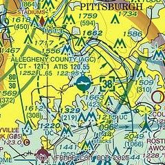
| Sectional chart |
|---|
|
CAUTION: Diagram may not be current
 Download PDF
of official airport diagram from the FAA
| Airport distance calculator |
|---|
|
|
| Sunrise and sunset |
|---|
|
Times for 21-May-2026
| | Local
(UTC-4) | | Zulu
(UTC) |
|---|
| Morning civil twilight | | 05:28 | | 09:28 |
| Sunrise | | 05:59 | | 09:59 |
| Sunset | | 20:33 | | 00:33 |
| Evening civil twilight | | 21:05 | | 01:05 |
|
| Current date and time |
|---|
| Zulu (UTC) | 21-May-2026 21:02:47 |
|---|
| Local (UTC-4) | 21-May-2026 17:02:47 |
|---|
|
| METAR |
|---|
| KAGC | 212053Z 06007KT 10SM SCT060 17/08 A3019 RMK AO2 SLP228 T01670083 56008
|
KP53
10nm SE | 212056Z AUTO 03009KT 06/02 A3037 RMK AO1 SLP291 T00610017 58015 $
|
KPIT
18nm NW | 212051Z 06008KT 10SM SCT110 BKN220 18/07 A3020 RMK AO2 SLP233 T01780067 56009
|
|
| TAF |
|---|
| KAGC | 211720Z 2118/2218 05008KT P6SM BKN070 FM220000 08008KT P6SM SCT060 FM221200 09006KT P6SM BKN025
|
KPIT
18nm NW | 211720Z 2118/2224 05008KT P6SM BKN070 FM220000 08007KT P6SM SCT060 FM221200 10010KT P6SM BKN025 FM222300 11012G20KT 4SM -RA BKN010
|
|
| NOTAMs |
|---|
NOTAMs are issued by the DoD/FAA and will open in a separate window not controlled by AirNav.
|
|


