FAA INFORMATION EFFECTIVE 15 MAY 2025
Location
| FAA Identifier: | DED |
| Lat/Long: | 29-04-01.3000N 081-17-01.5000W
29-04.021667N 081-17.025000W
29.0670278,-81.2837500
(estimated) |
| Elevation: | 79.1 ft. / 24.1 m (surveyed) |
| Variation: | 05W (2000) |
| From city: | 3 miles NE of DELAND, FL |
| Time zone: | UTC -4 (UTC -5 during Standard Time) |
| Zip code: | 32724 |
Airport Operations
| Airport use: | Open to the public |
| Activation date: | 04/1940 |
| Control tower: | no |
| ARTCC: | JACKSONVILLE CENTER |
| FSS: | SAINT PETERSBURG FLIGHT SERVICE STATION |
| NOTAMs facility: | PIE (NOTAM-D service available) |
| Attendance: | 0800-1800 |
| Wind indicator: | lighted |
| Segmented circle: | yes |
| Lights: | ACTVT REIL RWY 12 & 30; PAPI RWY 30; MIRL RWY 05/23, HIRL RWY 12/30 - CTAF. PAPI RWY 05, 12, & 23 OPER CONSLY. |
| Beacon: | white-green (lighted land airport)
Operates sunset to sunrise. |
Airport Communications
| CTAF/UNICOM: | 123.075 |
| WX AWOS-3: | 119.575 (386-740-5811) |
| DAYTONA APPROACH: | 125.35 |
| DAYTONA DEPARTURE: | 125.35 |
| TTHOR STAR: | 118.85 |
| WX ASOS at DAB (14 nm NE): | PHONE 386-232-5134 |
| WX AWOS-3 at OMN (17 nm NE): | 118.475 (386-615-7084) |
| WX AWOS-3 at EVB (18 nm E): | 124.625 (386-409-4705) |
| WX ASOS at SFB (18 nm S): | 125.975 (407-321-9384) |
Nearby radio navigation aids
| VOR radial/distance | | VOR name | | Freq | | Var |
|---|
| OMNr212/16.8 | | ORMOND BEACH VORTAC | | 112.60 | | 00E |
| ORLr005/31.6 | | ORLANDO VORTAC | | 112.20 | | 00E |
Airport Services
| Fuel available: | 100LL JET-A UL94
100LL:SELF SERVE 100LL AVBL 24 HRS WITH CREDIT CARD. |
| Parking: | hangars and tiedowns |
| Airframe service: | MAJOR |
| Powerplant service: | MAJOR |
| Bottled oxygen: | NONE |
| Bulk oxygen: | NONE |
Runway Information
Runway 12/30
| Dimensions: | 6001 x 100 ft. / 1829 x 30 m |
| Surface: | asphalt, in fair condition |
| Weight bearing capacity: | | PCN 35 /F/B/X/T | | Double wheel: | 60.0 |
|
| Runway edge lights: | high intensity |
| Runway edge markings: | RWY 30 MRKGS FADED & DISCOLORED. |
| RUNWAY 12 | | RUNWAY 30 |
| Latitude: | 29-04.344463N | | 29-03.894942N |
| Longitude: | 081-17.557638W | | 081-16.553487W |
| Elevation: | 73.7 ft. | | 70.1 ft. |
| Traffic pattern: | left | | left |
| Runway heading: | 122 magnetic, 117 true | | 302 magnetic, 297 true |
| Markings: | nonprecision, in poor condition | | nonprecision, in poor condition |
| Visual slope indicator: | 2-light PAPI on left (3.00 degrees glide path) | | 4-light PAPI on left (3.00 degrees glide path) |
| Runway end identifier lights: | yes | | yes |
| Touchdown point: | yes, no lights | | yes, no lights |
| Obstructions: | 26 ft. trees, 1105 ft. from runway, 75 ft. left of centerline, 34:1 slope to clear | | 66 ft. trees, 2220 ft. from runway, 235 ft. right of centerline, 30:1 slope to clear |
Runway 5/23
| Dimensions: | 4301 x 75 ft. / 1311 x 23 m |
| Surface: | asphalt, in fair condition |
| Weight bearing capacity: | | PCN 14 /F/B/Y/T | | Double wheel: | 40.0 |
|
| Runway edge lights: | medium intensity |
| Runway edge markings: | RWY 23 MRKGS FADED & DISCOLORED. |
| RUNWAY 5 | | RUNWAY 23 |
| Latitude: | 29-03.651372N | | 29-04.119435N |
| Longitude: | 081-17.287078W | | 081-16.679840W |
| Elevation: | 78.3 ft. | | 67.9 ft. |
| Traffic pattern: | left | | left |
| Runway heading: | 053 magnetic, 048 true | | 233 magnetic, 228 true |
| Markings: | nonprecision, in poor condition | | nonprecision, in poor condition |
| Visual slope indicator: | 2-light PAPI on left (3.00 degrees glide path) | | 2-light PAPI on left (3.00 degrees glide path) |
| Touchdown point: | yes, no lights | | yes, no lights |
| Obstructions: | 50 ft. trees, 1455 ft. from runway, 230 ft. left of centerline, 25:1 slope to clear | | 54 ft. trees, 2055 ft. from runway, 200 ft. left of centerline, 34:1 slope to clear |
Airport Ownership and Management from official FAA records
| Ownership: | Publicly-owned |
| Owner: | CITY OF DELAND
120 S FLORIDA AVE
DELAND, FL 32720
Phone 386-626-7107 |
| Manager: | JOHN EIFF
1000 FLIGHTLINE BLVD
DELAND, FL 32724
Phone 386-626-7240
ARPT PHYS ADS: 1000 FLIGHTLINE BLVD. |
Additional Remarks
| - | UNLIGTD OBSTNS IN THE APCH TO RWY 05 DUE TO TREES 51 FT TALL 1455 FT BFR AER. |
| - | TOUCH & GO OPNS PROHIBITED IF THERE ARE 3 OR MORE ACFT IN THE TFC PATTERN. |
| - | NOISE ABATEMENT PROCEDURES IN EFFECT, CALL AMGR (386) 740-6955. |
| - | EXTSV PARACHUTE & FLT TRNG OPNS. AVOID OVER FLYING ARPT DURG PARACHUTE OPNS. |
| - | NOISE SENSITIVE ARPT. AVOID OVER FLT OF RESIDENTIAL AREA S OF ARPT; AVOID WIDE DOWNWIND RY 23. JET ACFT USE NBAA NOISE ABATEMENT PROCEDURES. |
| - | CALM WIND RY 05. |
| - | LMTD SIGHT DISTANCES ALL RYS. |
| - | CTC UNICOM FOR TIE DOWN INFO. |
| - | FOR CD OR TO CNL IFR CTC DAYTONA APCH AT 386-226-3939. |
Instrument Procedures
NOTE: All procedures below are presented as PDF files. If you need a reader for these files, you should download the free Adobe Reader.NOT FOR NAVIGATION. Please procure official charts for flight.
FAA instrument procedures published for use from 15 May 2025 at 0901Z to 13 June 2025 at 0900z.
STARs - Standard Terminal Arrivals |
|---|
| TTHOR THREE (RNAV) | |
2 pages:
[1] [2] (333KB) |
IAPs - Instrument Approach Procedures |
|---|
| RNAV (GPS) RWY 05 | |
download (255KB) |
| RNAV (GPS) RWY 12 | |
download (245KB) |
| RNAV (GPS) RWY 23 | |
download (246KB) |
| RNAV (GPS) RWY 30 | |
download (218KB) |
| NOTE: Special Alternate Minimums apply | |
download (147KB) |
| NOTE: Special Take-Off Minimums/Departure Procedures apply | |
download (405KB) |
Other nearby airports with instrument procedures:
7FL6 - Spruce Creek Airport (12 nm E)
KDAB - Daytona Beach International Airport (14 nm NE)
KOMN - Ormond Beach Municipal Airport (17 nm NE)
KEVB - New Smyrna Beach Municipal Airport (Jack Bolt Field) (18 nm E)
KSFB - Orlando Sanford International Airport (18 nm S)
X50 - Massey Ranch Airpark (20 nm E)
|
|

Road maps at:
MapQuest
Bing
Google
| Aerial photo |
|---|
WARNING: Photo may not be current or correct
 Photo courtesy of Skydive DeLand
Photo taken 30-Oct-2014
looking north.
Photo courtesy of Skydive DeLand
Photo taken 30-Oct-2014
looking north.
Do you have a better or more recent aerial photo of DeLand Municipal Airport-Sidney H Taylor Field that you would like to share? If so, please send us your photo.
|
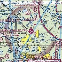
| Sectional chart |
|---|
|
| Airport distance calculator |
|---|
|
|
| Sunrise and sunset |
|---|
|
Times for 25-May-2025
| | Local
(UTC-4) | | Zulu
(UTC) |
|---|
| Morning civil twilight | | 06:03 | | 10:03 |
| Sunrise | | 06:30 | | 10:30 |
| Sunset | | 20:14 | | 00:14 |
| Evening civil twilight | | 20:41 | | 00:41 |
|
| Current date and time |
|---|
| Zulu (UTC) | 26-May-2025 00:44:22 |
|---|
| Local (UTC-4) | 25-May-2025 20:44:22 |
|---|
|
| METAR |
|---|
| KDED | 260035Z AUTO 06005KT 7SM -VCTSRA BR OVC110 22/21 A3011 RMK AO2 LTG DSNT NW THRU NE P0013 T02240213
|
KDAB
13nm NE | 260004Z 25016G26KT 1/2SM +TSRA BR SCT015CB BKN045 OVC090 23/21 A3014 RMK AO2 PK WND 24026/0001 SFC VIS 3 LTG DSNT SW-NW RAB2355 OCNL LTGICCG OHD-ALQDS TS OHD-ALQDS MOV NE P0002 T02280211 $
|
KOMN
16nm NE | 252250Z 18003KT 7SM SKC 25/25 A3008 RMK LTG DSNT S-NW LAST
|
KEVB
18nm E | 252347Z 20005KT 10SM FEW030 SCT090 BKN110 25/25 A3011
|
KSFB
18nm S | 252353Z 26007KT 9SM -RA FEW085 BKN110 24/23 A3013 RMK AO2 LTG DSNT ALQDS TSE2257 SLP200 P0003 60061 T02440233 10317 20233 50011
|
|
| TAF |
|---|
KDAB
13nm NE | 260014Z 2600/2624 12004KT P6SM VCTS FEW030 SCT060CB BKN090 TEMPO 2600/2601 VRB15G25KT 4SM TSRA BKN035CB FM260200 18003KT P6SM SCT040 BKN250 FM261500 21008KT P6SM FEW035 SCT250 FM261700 12006KT P6SM VCTS SCT040CB BKN250
|
KSFB
18nm S | 260013Z 2600/2624 VRB04KT P6SM VCSH FEW020 FEW050 BKN120 TEMPO 2600/2601 5SM -SHRA FM260200 VRB05KT P6SM FEW060 SCT120 BKN250 FM261500 19008KT P6SM FEW035 SCT250 FM261900 16008KT P6SM VCTS SCT040CB BKN250
|
|
| NOTAMs |
|---|
NOTAMs are issued by the DoD/FAA and will open in a separate window not controlled by AirNav.
|
|


