FAA INFORMATION EFFECTIVE 19 FEBRUARY 2026
Location
| FAA Identifier: | HAF |
| Lat/Long: | 37-30-48.4000N 122-30-04.2000W
37-30.806667N 122-30.070000W
37.5134444,-122.5011667
(estimated) |
| Elevation: | 66.3 ft. / 20.2 m (surveyed) |
| Variation: | 15E (1995) |
| From city: | 5 miles NW of HALF MOON BAY, CA |
| Time zone: | UTC -8 (UTC -7 during Daylight Saving Time) |
| Zip code: | 94038 |
Airport Operations
| Airport use: | Open to the public |
| Activation date: | 03/1943 |
| Control tower: | no |
| ARTCC: | OAKLAND CENTER |
| FSS: | OAKLAND FLIGHT SERVICE STATION |
| NOTAMs facility: | OAK (NOTAM-D service available) |
| Attendance: | 0830-1630 |
| Pattern altitude: | 999.3 ft. MSL |
| Wind indicator: | lighted |
| Segmented circle: | yes |
| Lights: | ACTVT MIRL RY 12/30, REIL RY 30, PAPI RYS 12 AND 30 - 122.8. |
| Beacon: | white-green (lighted land airport)
Operates sunset to sunrise. |
Airport Communications
| CTAF/UNICOM: | 122.8 |
| WX AWOS-3: | 127.275 (650-728-5649) |
| NORCAL APPROACH: | 135.1 |
| NORCAL DEPARTURE: | 135.1 |
| WX ASOS at SFO (9 nm NE): | PHONE 650-250-5841 |
| WX AWOS-3P at SQL (12 nm E): | 125.9 (650-593-0613) |
| WX AWOS-AV at 18CN (16 nm N): | 119.925 (415-514-4209) |
| WX ASOS at OAK (18 nm NE): | PHONE 510-214-1776 |
Nearby radio navigation aids
| VOR radial/distance | | VOR name | | Freq | | Var |
|---|
| SFOr207/8.8 | | SAN FRANCISCO VOR/DME | | 115.80 | | 17E |
| OSIr288/12.7 | | WOODSIDE VOR/DME | | 113.90 | | 17E |
| OAKr209/18.3 | | OAKLAND VOR/DME | | 116.80 | | 17E |
| SAUr160/20.5 | | SAUSALITO VOR/DME | | 116.20 | | 17E |
| SJCr271/27.8 | | SAN JOSE VOR/DME | | 114.10 | | 16E |
| PYEr136/38.2 | | POINT REYES VOR/DME | | 113.70 | | 17E |
| CCRr197/38.5 | | CONCORD VOR/DME | | 117.00 | | 17E |
Airport Services
| Fuel available: | 100LL
100LL:FUEL AVBL 24 HRS SELF SERVICE. |
| Parking: | tiedowns |
| Airframe service: | NONE |
| Powerplant service: | NONE |
| Bottled oxygen: | NONE |
| Bulk oxygen: | NONE |
Runway Information
Runway 12/30
| Dimensions: | 5000 x 150 ft. / 1524 x 46 m |
| Surface: | asphalt/concrete, in fair condition |
| Weight bearing capacity: | | Single wheel: | 30.0 | | Double wheel: | 200.0 | | Double tandem: | 360.0 |
|
| Runway edge lights: | medium intensity |
| RUNWAY 12 | | RUNWAY 30 |
| Latitude: | 37-31.107027N | | 37-30.505213N |
| Longitude: | 122-30.422895W | | 122-29.716655W |
| Elevation: | 66.3 ft. | | 32.5 ft. |
| Traffic pattern: | left | | right |
| Runway heading: | 122 magnetic, 137 true | | 302 magnetic, 317 true |
| Displaced threshold: | 752 ft. | | 762 ft. |
| Markings: | nonprecision, in good condition | | nonprecision, in good condition |
| Visual slope indicator: | 2-light PAPI on left (3.00 degrees glide path) | | 2-light PAPI on left (3.00 degrees glide path) |
| Runway end identifier lights: | no | | yes |
| Touchdown point: | yes, no lights | | yes, no lights |
| Obstructions: | 70 ft. trees, 1390 ft. from runway, 270 ft. right of centerline, 17:1 slope to clear
APCH RATIO TO DSPLCD THR 50:1. | | 70 ft. trees, 2478 ft. from runway, 180 ft. right of centerline, 32:1 slope to clear
APCH RATIO TO DSPLCD THR 50:1. |
Airport Ownership and Management from official FAA records
| Ownership: | Publicly-owned |
| Owner: | SAN MATEO COUNTY
555 COUNTY CENTER, 5TH FLOOR
REDWOOD CITY, CA 94063-1665
Phone 650-573-3700
DIRECTOR OF PUBLIC WORKS: JAMES C. PORTER |
| Manager: | GRETCHEN KELLY
620 AIRPORT DRIVE
SAN CARLOS, CA 94070
Phone 650-573-3700
MANAGERS OFFICE AIRPORT PHONE 650-573-3701. |
Additional Remarks
| - | FLD CONDS-RWY, TWY & APRON GOOD. |
| - | AVOID FLYING DIRECTLY OVER THE PILLAR POINT AIR FORCE STATION. |
| - | ARPT NOISE SENSITIVE AREAS NW THRU NE. |
| - | TWYS, APRONS AND TIEDOWNS: 12,500 LBS MAXIMUM. |
| - | FOR CD CTC NORCAL APCH AT 916-361-0519. |
| - | UNEXPECTED TURBULENT CONDS MAY BE ENCTRD WHILE ON FNA TO RWY 12. |
Instrument Procedures
NOTE: All procedures below are presented as PDF files. If you need a reader for these files, you should download the free Adobe Reader.NOT FOR NAVIGATION. Please procure official charts for flight.
FAA instrument procedures published for use from 19 February 2026 at 0901Z to 19 March 2026 at 0900Z.
IAPs - Instrument Approach Procedures |
|---|
| RNAV (GPS) RWY 12 | |
download (180KB) |
| RNAV (GPS) RWY 30 | |
download (187KB) |
|
|---|
| SEEMS ONE (OBSTACLE) (RNAV) | |
download (161KB) |
| NOTE: Special Take-Off Minimums/Departure Procedures apply | |
download (352KB) |
Other nearby airports with instrument procedures:
KSFO - San Francisco International Airport (9 nm NE)
KSQL - San Carlos Airport (12 nm E)
KOAK - Oakland San Francisco Bay Airport (18 nm NE)
KPAO - Palo Alto Airport (19 nm E)
KHWD - Hayward Executive Airport (20 nm NE)
|
|

Road maps at:
MapQuest
Bing
Google
| Aerial photo |
|---|
WARNING: Photo may not be current or correct
 Photo by David Newcomer
from 2,500' looking south.
Photo by David Newcomer
from 2,500' looking south.
Do you have a better or more recent aerial photo of Half Moon Bay Airport that you would like to share? If so, please send us your photo.
|
| Sectional chart |
|---|
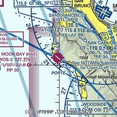
|
| Airport distance calculator |
|---|
|
|
| Sunrise and sunset |
|---|
|
Times for 23-Feb-2026
| | Local
(UTC-8) | | Zulu
(UTC) |
|---|
| Morning civil twilight | | 06:24 | | 14:24 |
| Sunrise | | 06:50 | | 14:50 |
| Sunset | | 17:57 | | 01:57 |
| Evening civil twilight | | 18:23 | | 02:23 |
|
| Current date and time |
|---|
| Zulu (UTC) | 23-Feb-2026 21:51:21 |
|---|
| Local (UTC-8) | 23-Feb-2026 13:51:21 |
|---|
|
| METAR |
|---|
| KHAF | 232135Z AUTO 23005KT 4SM BR SCT004 13/13 A3018 RMK AO2
|
KSFO
9nm NE | 232056Z 00000KT 10SM FEW160 SCT250 14/11 A3017 RMK AO2 SLP217 T01440111 56028
|
KSQL
12nm E | 232045Z 03005KT 20SM CLR 17/12 A3018
|
KOAK
18nm NE | 232053Z 00000KT 10SM FEW180 BKN250 16/09 A3019 RMK AO2 SLP223 T01560094 56028
|
KPAO
19nm E | 232047Z 01008KT 10SM SCT090 17/11 A3019
|
|
| TAF |
|---|
| KHAF | 231746Z 2318/2418 VRB04KT P6SM OVC004 FM231900 20007KT P6SM BKN150 FM240300 16010KT P6SM SCT030 BKN150 FM240900 18010G20KT 6SM BR VCSH SCT030 BKN080 FM241600 18012G24KT 6SM -RA BR SCT030 BKN080
|
KSFO
9nm NE | 231746Z 2318/2424 VRB05KT P6SM BKN150 FM240900 15008KT P6SM VCSH SCT030 OVC080 FM241700 16011G20KT 6SM -RA SCT030 OVC080 FM242300 18014G25KT 4SM -RA BR SCT030 OVC080
|
KOAK
18nm NE | 231746Z 2318/2424 VRB05KT P6SM BKN150 FM240900 12004KT P6SM VCSH OVC080 FM241700 15010G19KT 6SM -RA SCT030 OVC080 FM242300 16014G25KT 4SM -RA BR SCT030 OVC080
|
|
| NOTAMs |
|---|
NOTAMs are issued by the DoD/FAA and will open in a separate window not controlled by AirNav.
|
|

