FAA INFORMATION EFFECTIVE 15 MAY 2025
Location
| FAA Identifier: | MML |
| Lat/Long: | 44-27-06.2000N 095-49-27.9000W
44-27.103333N 095-49.465000W
44.4517222,-95.8244167
(estimated) |
| Elevation: | 1182.8 ft. / 360.5 m (surveyed) |
| Variation: | 05E (1995) |
| From city: | 1 mile W of MARSHALL, MN |
| Time zone: | UTC -5 (UTC -6 during Standard Time) |
| Zip code: | 56258 |
Airport Operations
| Airport use: | Open to the public |
| Activation date: | 04/1940 |
| Control tower: | no |
| ARTCC: | MINNEAPOLIS CENTER |
| FSS: | PRINCETON FLIGHT SERVICE STATION |
| NOTAMs facility: | MML (NOTAM-D service available) |
| Attendance: | MON-THU 0800-1700
FOR SVC AFT HRS CALL 507-532-3164. |
| Wind indicator: | lighted |
| Segmented circle: | no |
| Lights: | ACTVT MALSR RWY 12; MALSF RWY 30; REIL RWY 02 & 20; PAPI RWY 12, 30, 02, & 20; HIRL RWY 12/30; MIRL RWY 02/20 - CTAF. |
| Beacon: | white-green (lighted land airport)
Operates sunset to sunrise. |
Airport Communications
| CTAF/UNICOM: | 122.8 |
| WX AWOS-3PT: | 120.150 (507-532-5269) |
| WX AWOS-3PT at TKC (15 nm SE): | 120.0 (507-629-9006) |
- APCH/DEP SVC PRVDD BY MINNEAPOLIS ARTCC ON FREQS 127.1/290.2 (REDWOOD FALLS RCAG).
Nearby radio navigation aids
| VOR radial/distance | | VOR name | | Freq | | Var |
|---|
| MML at field | | MARSHALL VOR/DME | | 111.00 | | 05E |
| RWFr261/29.8 | | REDWOOD FALLS VOR/DME | | 113.30 | | 07E |
| MVEr184/31.6 | | MONTEVIDEO VOR/DME | | 111.60 | | 05E |
Airport Services
| Fuel available: | 100LL JET-A
100LL:FUEL AVBL H24 SELF SVC VIA CREDIT CARD. |
| Parking: | hangars and tiedowns |
| Airframe service: | MAJOR |
| Powerplant service: | MAJOR |
| Bottled oxygen: | NONE |
| Bulk oxygen: | NONE |
Runway Information
Runway 12/30
| Dimensions: | 7221 x 100 ft. / 2201 x 30 m |
| Surface: | asphalt, in fair condition |
| Weight bearing capacity: | | PCN 27 /F/B/X/T | | Single wheel: | 72.0 | | Double wheel: | 105.0 |
|
| Runway edge lights: | high intensity |
| RUNWAY 12 | | RUNWAY 30 |
| Latitude: | 44-27.513315N | | 44-26.750915N |
| Longitude: | 095-50.285672W | | 095-49.013078W |
| Elevation: | 1182.6 ft. | | 1178.5 ft. |
| Traffic pattern: | left | | left |
| Runway heading: | 125 magnetic, 130 true | | 305 magnetic, 310 true |
| Markings: | precision, in good condition | | precision, in good condition |
| Visual slope indicator: | 4-light PAPI on left (3.00 degrees glide path) | | 4-light PAPI on left (3.00 degrees glide path) |
| Approach lights: | MALSR: 1,400 foot medium intensity approach lighting system with runway alignment indicator lights | | MALSF: 1,400 foot medium intensity approach lighting system with sequenced flashers |
| Runway end identifier lights: | no | | no |
| Touchdown point: | yes, no lights | | yes, no lights |
| Instrument approach: | ILS | | |
Runway 2/20
| Dimensions: | 3999 x 75 ft. / 1219 x 23 m |
| Surface: | asphalt, in fair condition |
| Runway edge lights: | medium intensity |
| RUNWAY 2 | | RUNWAY 20 |
| Latitude: | 44-26.762098N | | 44-27.343140N |
| Longitude: | 095-49.348682W | | 095-48.917233W |
| Elevation: | 1179.9 ft. | | 1172.0 ft. |
| Traffic pattern: | left | | left |
| Runway heading: | 023 magnetic, 028 true | | 203 magnetic, 208 true |
| Markings: | nonprecision, in fair condition | | nonprecision, in fair condition |
| Visual slope indicator: | 4-light PAPI on left (3.00 degrees glide path) | | 4-light PAPI on left (3.00 degrees glide path) |
| Runway end identifier lights: | yes | | yes |
| Touchdown point: | yes, no lights | | yes, no lights |
Airport Ownership and Management from official FAA records
| Ownership: | Publicly-owned |
| Owner: | CITY OF MARSHALL
344 W MAIN ST
MARSHALL, MN 56258-1313
Phone 507-537-6760 |
| Manager: | JASON ANDERSON
344 W MAIN ST
MARSHALL, MN 56258-1313
Phone 507-537-6773 |
Additional Remarks
| - | GCO AVBL ON FREQ 121.725 THRU MINNEAPOLIS ARTCC & FLT SVCS. |
| - | FOR CD IF UNA TO CTC ON FSS FREQ, CTC MINNEAPOLIS ARTCC AT 651-463-5588. |
Instrument Procedures
NOTE: All procedures below are presented as PDF files. If you need a reader for these files, you should download the free Adobe Reader.NOT FOR NAVIGATION. Please procure official charts for flight.
FAA instrument procedures published for use from 15 May 2025 at 0901Z to 13 June 2025 at 0900z.
IAPs - Instrument Approach Procedures |
|---|
| ILS OR LOC RWY 12 | |
download (278KB) |
| RNAV (GPS) RWY 12 | |
download (259KB) |
| RNAV (GPS) RWY 30 | |
download (233KB) |
| VOR RWY 12 | |
download (248KB) |
| NOTE: Special Alternate Minimums apply | |
download (152KB) |
| NOTE: Special Take-Off Minimums/Departure Procedures apply | |
download (397KB) |
Other nearby airports with instrument procedures:
KTKC - Tracy Municipal Airport (15 nm SE)
KGDB - Granite Falls Municipal Airport/Lenzen-Roe-Fagen Memorial Field (21 nm NE)
KCNB - Myers Field Airport (25 nm NW)
KDVP - Slayton Municipal Airport (28 nm S)
KMVE - Montevideo-Chippewa County Airport (31 nm N)
|
|

Road maps at:
MapQuest
Bing
Google
| Aerial photo |
|---|
WARNING: Photo may not be current or correct
 Photo by Kreg Anderson
Photo taken 03-Aug-2011
looking south.
Photo by Kreg Anderson
Photo taken 03-Aug-2011
looking south.
Do you have a better or more recent aerial photo of Southwest Minnesota Regional Airport - Marshall/Ryan Field that you would like to share? If so, please send us your photo.
|
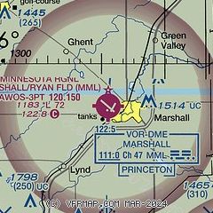
| Sectional chart |
|---|
|
| Airport distance calculator |
|---|
|
|
| Sunrise and sunset |
|---|
|
Times for 02-Jun-2025
| | Local
(UTC-5) | | Zulu
(UTC) |
|---|
| Morning civil twilight | | 05:06 | | 10:06 |
| Sunrise | | 05:42 | | 10:42 |
| Sunset | | 21:00 | | 02:00 |
| Evening civil twilight | | 21:36 | | 02:36 |
|
| Current date and time |
|---|
| Zulu (UTC) | 03-Jun-2025 00:46:06 |
|---|
| Local (UTC-5) | 02-Jun-2025 19:46:06 |
|---|
|
| METAR |
|---|
| KMML | 022356Z AUTO 35019KT 10SM CLR 27/18 A2964 RMK AO2 PK WND 31028/2333 WSHFT 2328 LTG DSNT E AND SE SLP033 T02720178 10344 20272 53026
|
KTKC
15nm SE | 030035Z AUTO 33012G20KT 10SM FEW065 FEW100 26/18 A2968 RMK AO2
|
|
| TAF |
|---|
KRWF
32nm E | 021720Z 0218/0318 19017G29KT P6SM SCT250 FM022300 22013G25KT 6SM -SHRA OVC050 TEMPO 0300/0303 4SM -TSRA BR OVC050CB FM030300 31011KT 6SM -SHRA OVC040 FM030700 33011KT 6SM FU OVC040
|
|
| NOTAMs |
|---|
NOTAMs are issued by the DoD/FAA and will open in a separate window not controlled by AirNav.
|
|


