FAA INFORMATION EFFECTIVE 15 MAY 2025
Location
| FAA Identifier: | NDZ |
| Lat/Long: | 30-41-54.8630N 087-00-51.8710W
30-41.914383N 087-00.864517W
30.6985731,-87.0144086
(estimated) |
| Elevation: | 177.4 ft. / 54.1 m (surveyed) |
| Variation: | 02W (2010) |
| From city: | 3 miles N of MILTON, FL |
| Time zone: | UTC -5 (UTC -6 during Standard Time) |
| Zip code: | 32570 |
Airport Operations
| Airport use: | Private use. Permission required prior to landing |
| Control tower: | yes |
| ARTCC: | JACKSONVILLE CENTER |
| FSS: | GAINESVILLE FLIGHT SERVICE STATION
NOTAM PNS. |
| Attendance: | MON-FRI 1145-0500Z++, ALL SAT-SUN CLSD, ALL HOL CLSD
CLSD SAT, SUN & HOL, OTR BY NOTAM. |
| Segmented circle: | no |
| Lights: | ACTVT MALSR RWY 32; PAPI RWY 05, 14, 23, & 32; HIRL 05/23 & 14/32 -CTAF. |
| Beacon: | white-green (lighted land airport)
Operates sunset to sunrise. |
Airport Communications
| CTAF: | 355.6 |
| ATIS: | 273.575 |
| WX ASOS: | PHONE 850-623-7210 |
| SOUTH WHITING GROUND: | 317.65 [1300-0400Z++ MON-THU; 1400-0400Z++ FRI; 2300-0300Z++ SUN; CLSD SAT & HOL OR NOTAM.] |
| SOUTH WHITING TOWER: | 123.075 348.675 [1300-0400Z++ MON-THU; 1400-0400Z++ FRI; 2300-0300Z++ SUN; CLSD SAT & HOL OR NOTAM.] |
| PENSACOLA APPROACH: | 124.85 |
| PENSACOLA DEPARTURE: | 124.85 |
| CLEARANCE DELIVERY: | 355.6 |
| BASE OPS: | 233.7 |
| PMSV METRO: | 316.95 |
| WX ASOS at NSE (1.5 nm N): | PHONE 850-623-7241 |
| WX ASOS at PNS (16 nm SW): | 121.25 (850-436-4799) |
- TSNT CTC TRANSIENT LINE 30 MIN PRIOR TO ARR FOR SVC.
- PMSV AVBL DURG OPS HRS.
Nearby radio navigation aids
| VOR radial/distance | | VOR name | | Freq | | Var |
|---|
| CEWr243/18.9 | | CRESTVIEW VORTAC | | 115.90 | | 03E |
| NUNr050/(21.5) | | SAUFLEY VOR | | 112.25 | | 01E |
Airport Services
| Fuel available: | 100LL |
| Airframe service: | NONE |
| Powerplant service: | NONE |
| Bottled oxygen: | NONE |
| Bulk oxygen: | NONE |
Runway Information
Runway 14/32
| Dimensions: | 6002 x 200 ft. / 1829 x 61 m |
| Surface: | asphalt, in fair condition |
| Weight bearing capacity: | |
| Runway edge lights: | high intensity |
| RUNWAY 14 | | RUNWAY 32 |
| Latitude: | 30-42.177833N | | 30-41.452167N |
| Longitude: | 087-01.378000W | | 087-00.598667W |
| Elevation: | 169.9 ft. | | 165.3 ft. |
| Traffic pattern: | left | | left |
| Runway heading: | 139 magnetic, 137 true | | 319 magnetic, 317 true |
| Markings: | precision, in fair condition | | precision, in fair condition |
| Visual slope indicator: | 4-light PAPI on left (3.00 degrees glide path) | | 4-light PAPI on left (3.00 degrees glide path) |
| Approach lights: | | | MALSR: 1,400 foot medium intensity approach lighting system with runway alignment indicator lights |
| Touchdown point: | yes, no lights | | yes, no lights |
| Instrument approach: | | | ILS/DME |
Runway 5/23
| Dimensions: | 5996 x 200 ft. / 1828 x 61 m |
| Surface: | asphalt, in fair condition |
| Weight bearing capacity: | |
| Runway edge lights: | high intensity |
| RUNWAY 5 | | RUNWAY 23 |
| Latitude: | 30-41.677167N | | 30-42.350500N |
| Longitude: | 087-01.159833W | | 087-00.321333W |
| Elevation: | 161.7 ft. | | 170.9 ft. |
| Traffic pattern: | left | | left |
| Runway heading: | 049 magnetic, 047 true | | 229 magnetic, 227 true |
| Markings: | precision, in fair condition | | precision, in fair condition |
| Visual slope indicator: | 4-light PAPI on left (3.00 degrees glide path) | | 4-light PAPI on left (3.00 degrees glide path) |
| Touchdown point: | yes, no lights | | yes, no lights |
Helipad H-A
| Dimensions: | 100 x 100 ft. / 30 x 30 m |
| Surface: | asphalt |
| Operational restrictions: | W SIDE OF RWY 14, H-A CENTER N30DEG41.821'/W087DEG01.177'. |
| Traffic pattern: | left | | left |
Helipad H-B
| Dimensions: | 100 x 100 ft. / 30 x 30 m |
| Surface: | asphalt |
| Operational restrictions: | W SIDE OF RWY 32, H-B CENTER N30DEG41.603'/W087DEG00.944'. |
| Traffic pattern: | left | | left |
Helipad H-C
| Dimensions: | 100 x 100 ft. / 30 x 30 m |
| Surface: | asphalt |
| Operational restrictions: | E SIDE OF CLOSED RWY, H-C CENTER N30DEG41.803'/ W087DEG00.697'. |
| Traffic pattern: | left | | left |
Helipad H-D
| Dimensions: | 100 x 100 ft. / 30 x 30 m |
| Surface: | asphalt |
| Operational restrictions: | S SIDE OF CLSD RWY, H-D CENTER N30DEG41.929'/W087DEG00.650'. |
| Traffic pattern: | left | | left |
Helipad H-E
| Dimensions: | 100 x 100 ft. / 30 x 30 m |
| Surface: | asphalt |
| Operational restrictions: | N SIDE OF CLSD RWY, H-E CENTER N30DEG42.064'/W087DEG00.483'. |
| Traffic pattern: | left | | left |
Helipad H-F
| Dimensions: | 100 x 100 ft. / 30 x 30 m |
| Surface: | asphalt |
| Operational restrictions: | SE SIDE OF RWY 23, H-F CENTERN30DEG42.172'/W087DEG00.348'. |
| Traffic pattern: | left | | left |
Helipad H1
| Dimensions: | 100 x 100 ft. / 30 x 30 m |
| Surface: | asphalt |
| Operational restrictions: | MIDFIELD RWY 5-23, H1 CENTER N30DEG42.013'/W087DEG00.742'. |
| Traffic pattern: | left | | left |
Helipad H2
| Dimensions: | 100 x 100 ft. / 30 x 30 m |
| Surface: | asphalt |
| Operational restrictions: | APCH END RWY 14, H2 CENTER N30DEG42.093'/W087DEG01.288'. |
| Traffic pattern: | left | | left |
Helipad H3
| Dimensions: | 100 x 100 ft. / 30 x 30 m |
| Surface: | asphalt |
| Operational restrictions: | APCH END RWY 14 ABEAM RAMP, H3 CENTER N30DEG42.026'/ W087DEG01.215'. |
| Traffic pattern: | left | | left |
Helipad H4
| Dimensions: | 100 x 100 ft. / 30 x 30 m |
| Surface: | asphalt |
| Operational restrictions: | INT RWY 14-32/5-23, H4 CENTER N30DEG41.815'/W087DEG00.989'. |
| Traffic pattern: | left | | left |
Helipad H5
| Dimensions: | 100 x 100 ft. / 30 x 30 m |
| Surface: | asphalt |
| Operational restrictions: | APCH END RWY 32, H5 CENTER N30DEG41.598'/W087DEG00.757'. |
| Traffic pattern: | left | | left |
Helipad H6
| Dimensions: | 75 x 100 ft. / 23 x 30 m |
| Surface: | asphalt |
| Operational restrictions: | Y TWY ADJACENT RWY 23, H6 CENTER N30DEG42.383'/ W087DEG00.388'. |
| Traffic pattern: | left | | left |
Airport Ownership and Management from official FAA records
| Ownership: | U.S. Navy |
| Owner: | US NAVY
OCEANOGRAPHIC OFC-CODE 3142
WASHINGTON, DC 20373 |
| Manager: | COMMANDING OFFICER
NAVAL AIR STATION WHITING FLD
MILTON, FL 32570 |
Additional Remarks
| - | CTN: HEL TRNG OPS ALL HRS; NO OVRN. |
| - | DD-1801 WX CODES OBTAINED AT HTTPS:/FWB.METOC.NAVY.MIL. WX AFT HR - AWS/NORFOLK 1-888-745-6899. |
| - | TWY Z NORTH OF LANGLEY RD NOT VSB FM ATCT. |
| - | PONDING OCRS AFT RAIN - BRAP. |
| - | TRAN ALERT: TSNT PRAC APCH 24 HR PPR- D868-7598. TSNT LINE SVC AVBL 1400-2200Z++ MON-FRI ONLY; LTD TSNT PRK AVBL; 5 DAY NTC FOR GND SUPPORT EQPT - D868-7717. TSNT CTC BASE OPS 10 MIN PRIOR ARR. TSNT PAR EXP RADAR VECTORS RWY 32. |
| - | BDRY LGTD HELI LCTD N OF ARPT; SAR AND VIP USE ONLY. |
| - | SMT WHITING FLD FP - FAX C850-623-7356 OR WHTG_NASWF_BASEOPS.FCT@NAVY.MIL; CFM FP - FPG DISPATCH D868-7598/7597/7654 OR C850-623-7598/7597/7654. |
| - | CTC DUTY OPS DSN 868-7475; C850-623-7475 FOR INFO, PPR, AND CALP OR EMAIL: WHTG_NASWF_AIRPOS_AFM@NAVY.MIL PPR 24 HR PN. |
| - | FUEL: J8, JASU-1(NC-8), A++. |
Instrument Procedures
NOTE: All procedures below are presented as PDF files. If you need a reader for these files, you should download the free Adobe Reader.NOT FOR NAVIGATION. Please procure official charts for flight.
FAA instrument procedures published for use from 15 May 2025 at 0901Z to 13 June 2025 at 0900z.
IAPs - Instrument Approach Procedures |
|---|
| ILS Y OR LOC Y RWY 32 | |
download (147KB) |
| ILS Z OR RNAV (GPS) RWY 32 | |
download (150KB) |
| TACAN RWY 32 | |
download (145KB) |
| COPTER RNAV (GPS) 004 | |
download (122KB) |
| COPTER TACAN 004 | |
download (115KB) |
| Radar Approach Procedures available **CHANGED** | |
download (175KB) |
| NOTE: Special Take-Off Minimums/Departure Procedures apply | |
download (404KB) |
Other nearby airports with instrument procedures:
KNSE - Whiting Field Naval Air Station North (2 nm N)
2R4 - Peter Prince Field Airport (4 nm S)
KPNS - Pensacola International Airport (16 nm SW)
12J - Brewton Municipal Airport (21 nm N)
KHRT - Hurlburt Field Airport (23 nm SE)
|
|

Road maps at:
MapQuest
Bing
Google
| Aerial photo |
|---|
WARNING: Photo may not be current or correct
 looking northwest.
KNDZ in foreground (bottom of photo), KNSE in background (top of photo)
Do you have a better or more recent aerial photo of Whiting Field Naval Air Station South that you would like to share? If so, please send us your photo.
|
| Sectional chart |
|---|
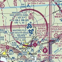
|
 Download PDF
of official airport diagram from the FAA
| Airport distance calculator |
|---|
|
|
| Sunrise and sunset |
|---|
|
Times for 15-May-2025
| | Local
(UTC-5) | | Zulu
(UTC) |
|---|
| Morning civil twilight | | 05:28 | | 10:28 |
| Sunrise | | 05:54 | | 10:54 |
| Sunset | | 19:35 | | 00:35 |
| Evening civil twilight | | 20:01 | | 01:01 |
|
| Current date and time |
|---|
| Zulu (UTC) | 16-May-2025 00:33:41 |
|---|
| Local (UTC-5) | 15-May-2025 19:33:41 |
|---|
|
| METAR |
|---|
| KNDZ | 152356Z 20006KT 10SM FEW020 SCT250 26/23 A2995 RMK AO2 SLP127 T02610228 10322 20261 53002 $
|
| KNSE | 152356Z 18009KT 10SM FEW018 BKN250 26/23 A2995 RMK AO2 SLP127 T02610228 10317 20261 53002 $
|
KPNS
16nm SW | 160000Z 21007KT 10SM BKN017 OVC024 26/23 A2995 RMK AO2 T02610228
|
|
| TAF |
|---|
| KNSE | 1523/1623 20010G15KT 9999 SCT018 SCT250 QNH2992INS BECMG 1602/1603 23007KT 9999 FEW008 BKN015 BKN250 QNH2991INS FM161200 24006KT 9999 SCT012 BKN025 BKN250 QNH2994INS FM161600 22012G18KT 9999 SCT015 BKN200 QNH2995INS FM161800 22013G22KT 9999 SCT035 BKN200 QNH2992INS AUTOMATED SENSOR METWATCH 1604 TIL 1611 TX31/1619Z TN22/1609Z FN20029
|
KPNS
16nm SW | 151731Z 1518/1618 21014KT P6SM FEW021 SCT027 BKN035 FM160900 21005KT P6SM OVC015 FM161200 18002KT 4SM BR BKN015 FM161500 18007KT P6SM SCT250
|
|
| NOTAMs |
|---|
NOTAMs are issued by the DoD/FAA and will open in a separate window not controlled by AirNav.
|
|


