FAA INFORMATION EFFECTIVE 15 MAY 2025
Location
| FAA Identifier: | PTB |
| Lat/Long: | 37-11-03.4850N 077-30-22.2280W
37-11.058083N 077-30.370467W
37.1843014,-77.5061744
(estimated) |
| Elevation: | 192.7 ft. / 58.7 m (surveyed) |
| Variation: | 08W (1985) |
| From city: | 5 miles SW of PETERSBURG, VA |
| Time zone: | UTC -4 (UTC -5 during Standard Time) |
| Zip code: | 23803 |
Airport Operations
| Airport use: | Open to the public |
| Activation date: | 04/1976 |
| Control tower: | no |
| ARTCC: | WASHINGTON CENTER |
| FSS: | LEESBURG FLIGHT SERVICE STATION |
| NOTAMs facility: | PTB (NOTAM-D service available) |
| Attendance: | OCT-MAR MON-SUN 0700-1800, ARP-SEPT MON-SUN 0700-1900 |
| Pattern altitude: | 992.7 ft. MSL |
| Wind indicator: | lighted |
| Segmented circle: | no |
| Lights: | ACTVT ODALS RWY 05; REIL RWY 23; PAPI RWYS 05 & 23; & MIRL RWY 05/23 - CTAF. |
| Beacon: | white-green (lighted land airport)
Operates sunset to sunrise. |
Airport Communications
| CTAF/UNICOM: | 122.7 |
| WX AWOS-3: | 133.325 (804-861-5551) |
| POTOMAC APPROACH: | 126.75 |
| POTOMAC DEPARTURE: | 126.75 |
| WX AWOS-3PT at FCI (13 nm N): | 128.625 (804-271-8426) |
- APCH/DEP SVC PRVDD BY POTOMAC TRACON 126.75/307.2.
Nearby radio navigation aids
| VOR radial/distance | | VOR name | | Freq | | Var |
|---|
| HPWr251/20.6 | | HOPEWELL VORTAC | | 114.35 | | 06W |
| RICr214/21.0 | | RICHMOND VORTAC | | 114.10 | | 09W |
| FAKr149/25.7 | | FLAT ROCK VORTAC | | 113.30 | | 06W |
| NDB name | | Hdg/Dist | | Freq | | Var | | ID |
|---|
| BLACKSTONE | | 091/26.0 | | 326 | | 09W | | BKT | -... -.- - |
| WAKEFIELD | | 308/27.0 | | 274 | | 11W | | AKQ | .- -.- --.- |
Airport Services
| Fuel available: | 100LL JET-A
100LL:SELF SVC FUELING AVBL AFTER HRS. |
| Parking: | hangars and tiedowns |
| Airframe service: | MAJOR |
| Powerplant service: | MAJOR |
Runway Information
Runway 5/23
| Dimensions: | 5002 x 100 ft. / 1525 x 30 m |
| Surface: | asphalt/grooved, in good condition |
| Weight bearing capacity: | |
| Runway edge lights: | medium intensity |
| RUNWAY 5 | | RUNWAY 23 |
| Latitude: | 37-10.756250N | | 37-11.359907N |
| Longitude: | 077-30.721125W | | 077-30.019772W |
| Elevation: | 192.7 ft. | | 189.8 ft. |
| Traffic pattern: | left | | left |
| Runway heading: | 051 magnetic, 043 true | | 231 magnetic, 223 true |
| Markings: | nonprecision, in good condition | | nonprecision, in good condition |
| Visual slope indicator: | 4-light PAPI on left (3.00 degrees glide path) | | 4-light PAPI on left (3.00 degrees glide path) |
| Approach lights: | ODALS: omnidirectional approach lighting system | | |
| Runway end identifier lights: | no | | yes |
| Touchdown point: | yes, no lights | | yes, no lights |
| Instrument approach: | LOC/DME | | |
| Obstructions: | 35 ft. tree, 1117 ft. from runway, 227 ft. left of centerline, 26:1 slope to clear | | 71 ft. tree, 3432 ft. from runway, 325 ft. right of centerline, 45:1 slope to clear |
Airport Ownership and Management from official FAA records
| Ownership: | Publicly-owned |
| Owner: | DINWIDDIE ARPT AND INDUSTRIAL AUTH.
6775 BECK-CHAPPELL DRIVE
PETERSBURG, VA 23803
Phone 804-861-0218 |
| Manager: | JEREMY PULTZ
6775 BECK-CHAPPELL DRIVE
PETERSBURG, VA 23803
Phone 804-861-0218 |
Additional Remarks
| - | CONC PADS ON MAIN APRON AVBL FOR HEL PRKG. CTC UNICOM FOR TRML HEL PRKG. |
| - | GCO AVBL ON FREQ 135.075 THRU POTOMAC APCH CD. IF UNA, FOR CD CTC POTOMAC APCH AT 866-640-4124. |
| - | HELICOPTERS APCH PARL TO RWY 05/23 & TRANSITION PERPENDICULAR TO RWY 05/23 TO HELIPADS ON NE CORNER OF APRON. |
| - | ULTRALIGHT ACT ON & INVOF ARPT. |
Instrument Procedures
NOTE: All procedures below are presented as PDF files. If you need a reader for these files, you should download the free Adobe Reader.NOT FOR NAVIGATION. Please procure official charts for flight.
FAA instrument procedures published for use from 15 May 2025 at 0901Z to 13 June 2025 at 0900z.
IAPs - Instrument Approach Procedures |
|---|
| RNAV (GPS) RWY 05 | |
download (211KB) |
| RNAV (GPS) RWY 23 | |
download (219KB) |
| LOC RWY 05 | |
download (288KB) |
| VOR RWY 23 | |
download (296KB) |
| NOTE: Special Alternate Minimums apply | |
download (167KB) |
| NOTE: Special Take-Off Minimums/Departure Procedures apply | |
download (363KB) |
Other nearby airports with instrument procedures:
KFCI - Richmond Executive-Chesterfield County Airport (13 nm N)
KRIC - Richmond International Airport (21 nm NE)
KBKT - Allan C Perkinson/Blackstone AAF Airport (22 nm W)
W96 - New Kent County Airport (26 nm NE)
KAKQ - Wakefield Municipal Airport (27 nm SE)
|
|

Road maps at:
MapQuest
Bing
Google
| Aerial photo |
|---|
WARNING: Photo may not be current or correct
 Photo taken 21-Sep-2006
with Kodak DX7590 digital camera
Photo taken 21-Sep-2006
with Kodak DX7590 digital camera
Do you have a better or more recent aerial photo of Tri Cities Executive/Dinwiddie County Airport that you would like to share? If so, please send us your photo.
|
| Sectional chart |
|---|
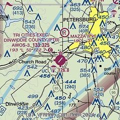
|
| Airport distance calculator |
|---|
|
|
| Sunrise and sunset |
|---|
|
Times for 30-May-2025
| | Local
(UTC-4) | | Zulu
(UTC) |
|---|
| Morning civil twilight | | 05:23 | | 09:23 |
| Sunrise | | 05:53 | | 09:53 |
| Sunset | | 20:22 | | 00:22 |
| Evening civil twilight | | 20:52 | | 00:52 |
|
| Current date and time |
|---|
| Zulu (UTC) | 30-May-2025 18:30:20 |
|---|
| Local (UTC-4) | 30-May-2025 14:30:20 |
|---|
|
| METAR |
|---|
| KPTB | 301815Z AUTO 25006KT 10SM SCT017 SCT025 BKN031 24/19 A2968 RMK AO2 T02420185
|
KFCI
13nm N | 301824Z AUTO 18009KT 10SM BKN026 BKN031 24/19 A2967 RMK AO2
|
|
| TAF |
|---|
KRIC
22nm NE | 301730Z 3018/3118 20007KT P6SM BKN030 BKN200 FM302100 21011KT P6SM VCTS BKN040CB BKN200 TEMPO 3022/3024 VRB20G30KT 3SM TSRA FEW010 BKN025CB FM310100 27013G21KT P6SM SCT030 BKN050 FM310800 24009KT P6SM SCT100
|
|
| NOTAMs |
|---|
NOTAMs are issued by the DoD/FAA and will open in a separate window not controlled by AirNav.
|
|


