FAA INFORMATION EFFECTIVE 23 JANUARY 2025
Location
| FAA Identifier: | EQY |
| Lat/Long: | 35-01-02.6980N 080-37-19.4010W
35-01.044967N 080-37.323350W
35.0174161,-80.6220558
(estimated) |
| Elevation: | 682.5 ft. / 208.0 m (surveyed) |
| Variation: | 06W (1990) |
| From city: | 5 miles NW of MONROE, NC |
| Time zone: | UTC -5 (UTC -4 during Daylight Saving Time) |
| Zip code: | 28110 |
Airport Operations
| Airport use: | Open to the public |
| Control tower: | no |
| ARTCC: | ATLANTA CENTER |
| FSS: | RALEIGH FLIGHT SERVICE STATION |
| NOTAMs facility: | EQY (NOTAM-D service available) |
| Attendance: | 0700-1900 |
| Wind indicator: | lighted |
| Segmented circle: | yes |
| Lights: | ACTVT MALSR RWY 05; REIL RWY 23; HIRL RWY 05/23 - CTAF. ALL LIGHTS OPER DUSK-0000. AFTER 0000, ACTVT - 122.7. PAPI RWY 05 & 23 OPER CONSLY. |
| Beacon: | white-green (lighted land airport)
Operates sunset to sunrise. |
| International operations: | customs landing rights airport |
Airport Communications
| CTAF/UNICOM: | 122.7 |
| WX ASOS: | 135.775 (704-283-5185) |
| CHARLOTTE APPROACH: | 120.05 |
| CHARLOTTE DEPARTURE: | 120.05 |
| CLEARANCE DELIVERY: | 132.55 |
| BARMY DP: | 120.05 |
| BEAVY DP: | 120.05 |
| BOBZY DP: | 120.05 |
| ESTRR DP: | 120.05 |
| ICONS DP: | 120.05 |
| JOJJO DP: | 120.05 |
| JOOLS STAR: | 135.6 |
| KERMIT DP: | 120.05 |
| KILNS DP: | 120.05 |
| KNIGHTS DP: | 120.05 |
| KRITR DP: | 120.05 |
| KWEEN DP: | 120.05 |
| LILLS DP: | 120.05 |
| RASLN STAR: | 126.15 |
| WEAZL DP: | 120.05 |
| WX ASOS at CLT (20 nm NW): | PHONE 704-790-5484 |
Nearby radio navigation aids
| VOR radial/distance | | VOR name | | Freq | | Var |
|---|
| CLTr128/19.2 | | CHARLOTTE VOR/DME | | 115.00 | | 05W |
| CTFr325/27.9 | | CHESTERFIELD VOR/DME | | 114.55 | | 03W |
| NDB name | | Hdg/Dist | | Freq | | Var | | ID |
|---|
| STONIA | | 118/28.3 | | 260 | | 06W | | GHJ | --. .... .--- |
| CHESTER | | 070/31.7 | | 220 | | 06W | | DCM | -.. -.-. -- |
Airport Services
| Fuel available: | 100LL JET-A1+
100LL:FUEL 24 HR CREDIT CARD SVC AVBL. |
| Parking: | hangars and tiedowns |
| Airframe service: | MAJOR |
| Powerplant service: | MAJOR |
| Bottled oxygen: | HIGH/LOW |
| Bulk oxygen: | NONE |
Runway Information
Runway 5/23
| Dimensions: | 7001 x 100 ft. / 2134 x 30 m |
| Surface: | asphalt, in good condition |
| Weight bearing capacity: | | Single wheel: | 35.0 | | Double wheel: | 68.5 |
|
| Runway edge lights: | high intensity |
| RUNWAY 5 | | RUNWAY 23 |
| Latitude: | 35-00.651308N | | 35-01.438598N |
| Longitude: | 080-37.836198W | | 080-36.810413W |
| Elevation: | 682.5 ft. | | 662.0 ft. |
| Traffic pattern: | left | | left |
| Runway heading: | 053 magnetic, 047 true | | 233 magnetic, 227 true |
| Markings: | precision, in good condition | | nonprecision, in good condition |
| Visual slope indicator: | 4-light PAPI on left (3.00 degrees glide path) | | 4-light PAPI on left (3.00 degrees glide path) |
| Approach lights: | MALSR: 1,400 foot medium intensity approach lighting system with runway alignment indicator lights | | |
| Runway end identifier lights: | no | | yes |
| Touchdown point: | yes, no lights | | yes, no lights |
| Instrument approach: | ILS/DME | | |
| Obstructions: | 36 ft. trees, 1963 ft. from runway, 382 ft. right of centerline, 48:1 slope to clear | | 25 ft. trees, 1095 ft. from runway, 431 ft. right of centerline, 35:1 slope to clear
63 FT TREES LOCATED 0-200 FT FM THR AND OFFSET 401 FT L. |
Airport Ownership and Management from official FAA records
| Ownership: | Publicly-owned |
| Owner: | CITY OF MONROE
CITY HALL, P.O. BOX 69
MONROE, NC 28111
Phone 704-282-4731 |
| Manager: | MALCOLM WEEKS
3900 PAUL J. HELMS DRIVE
MONROE, NC 28110
Phone 704-282-4730 |
Additional Remarks
| - | ARPT PHONE NUMBER 704-282-4730. |
| - | DEER, WILDLIFE, AND BIRDS ON AND INVOF ARPT. |
| - | RIGHT SIDE OF TWY A AT RWY 23 HAS STEEP SHOULDER DROP-OFF BTN RWY AND TWY A. |
| - | FOR CD CTC CHARLOTTE APCH AT 704-359-0241. |
Instrument Procedures
NOTE: All procedures below are presented as PDF files. If you need a reader for these files, you should download the free Adobe Reader.NOT FOR NAVIGATION. Please procure official charts for flight.
FAA instrument procedures published for use from 23 January 2025 at 0901Z to 20 February 2025 at 0900z.
STARs - Standard Terminal Arrivals |
|---|
| JOOLS ONE (RNAV) | |
download (273KB) |
| LIINN THREE | |
2 pages:
[1] [2] (280KB) |
| MAJIC FOUR | |
download (262KB) |
| RASLN THREE | |
download (177KB) |
IAPs - Instrument Approach Procedures |
|---|
| ILS OR LOC RWY 05 | |
download (292KB) |
| RNAV (GPS) RWY 05 | |
download (227KB) |
| RNAV (GPS) RWY 23 | |
download (224KB) |
| NOTE: Special Alternate Minimums apply | |
download (167KB) |
Departure Procedures |
|---|
| BARMY FIVE (RNAV) | |
download (193KB) |
| BEAVY SIX (RNAV) | |
download (178KB) |
| BOBZY FIVE (RNAV) | |
download (195KB) |
| ESTRR FIVE (RNAV) | |
download (163KB) |
| ICONS FIVE (RNAV) | |
download (167KB) |
| JOJJO FIVE (RNAV) | |
download (216KB) |
| KERMIT FOUR | |
2 pages:
[1] [2] (373KB) |
| KILNS FIVE (RNAV) | |
download (168KB) |
| KNIGHTS THREE | |
2 pages:
[1] [2] (365KB) |
| KRITR SIX (RNAV) | |
download (166KB) |
| KWEEN FIVE (RNAV) | |
download (168KB) |
| LILLS THREE (RNAV) | |
download (146KB) |
| WEAZL FIVE (RNAV) | |
download (146KB) |
| NOTE: Special Take-Off Minimums/Departure Procedures apply | |
download (363KB) |
Other nearby airports with instrument procedures:
N52 - JAARS-Townsend Airport (11 nm SW)
KCLT - Charlotte/Douglas International Airport (20 nm NW)
KLKR - Lancaster County Airport-Mc Whirter Field (21 nm SW)
KPYG - Pageland Airport (21 nm SE)
KUZA - Rock Hill (York County) Airport-Bryant Field (21 nm W)
|
|

Road maps at:
MapQuest
Bing
Google
| Aerial photo |
|---|
WARNING: Photo may not be current or correct
 Photo taken 14-Oct-2007
on final for runway 5
Photo taken 14-Oct-2007
on final for runway 5
Do you have a better or more recent aerial photo of Charlotte-Monroe Executive Airport that you would like to share? If so, please send us your photo.
|
| Sectional chart |
|---|
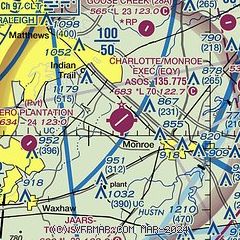
|
| Airport distance calculator |
|---|
|
|
| Sunrise and sunset |
|---|
|
Times for 08-Feb-2025
| | Local
(UTC-5) | | Zulu
(UTC) |
|---|
| Morning civil twilight | | 06:50 | | 11:50 |
| Sunrise | | 07:17 | | 12:17 |
| Sunset | | 17:57 | | 22:57 |
| Evening civil twilight | | 18:23 | | 23:23 |
|
| Current date and time |
|---|
| Zulu (UTC) | 08-Feb-2025 12:01:29 |
|---|
| Local (UTC-5) | 08-Feb-2025 07:01:29 |
|---|
|
| METAR |
|---|
| KEQY | 081153Z AUTO 04006KT 10SM FEW047 SCT060 11/00 A3013 RMK AO2 SLP213 60000 70006 T01060000 10150 20100 51010
|
|
| TAF |
|---|
KCLT
20nm NW | 081125Z 0812/0918 04006KT P6SM FEW028 BKN045 FM081300 06005KT P6SM BKN027 FM081800 10004KT P6SM OVC019 FM082200 VRB04KT P6SM SCT017 BKN035 FM090300 22007KT P6SM BKN070 BKN250 FM090500 23009KT P6SM SCT018 BKN035 WS020/23040KT
|
|
| NOTAMs |
|---|
NOTAMs are issued by the DoD/FAA and will open in a separate window not controlled by AirNav.
|
|


