FAA INFORMATION EFFECTIVE 05 SEPTEMBER 2024
Location
| FAA Identifier: | MMV |
| Lat/Long: | 45-11-40.4000N 123-08-09.8000W
45-11.673333N 123-08.163333W
45.1945556,-123.1360556
(estimated) |
| Elevation: | 162.6 ft. / 49.6 m (surveyed) |
| Variation: | 19E (1990) |
| From city: | 3 miles SE of MC MINNVILLE, OR |
| Time zone: | UTC -7 (UTC -8 during Standard Time) |
| Zip code: | 97128 |
Airport Operations
| Airport use: | Open to the public |
| Activation date: | 12/1943 |
| Control tower: | no |
| ARTCC: | SEATTLE CENTER |
| FSS: | MC MINNVILLE FLIGHT SERVICE STATION
ADDNL PHONE NR. TO FSS LC434-5508. |
| NOTAMs facility: | MMV (NOTAM-D service available) |
| Attendance: | 1600-0100Z |
| Wind indicator: | lighted |
| Segmented circle: | yes |
| Lights: | ACTVT MALSR RWY 22; REIL RWY 04; PAPI RWY 22; HIRL RWY 04/22 - CTAF. PAPI RWY 22 OPR CONSLY; CTL INTST USING CTAF. |
| Beacon: | white-green (lighted land airport)
Operates sunset to sunrise. |
Airport Communications
| CTAF/UNICOM: | 123.0 |
| WX ASOS: | 135.675 (503-434-9153) |
| PORTLAND APPROACH: | 118.1 ;NORTH 126.0 ;NORTH [MON-FRI 0800-1600 EXC WKENDS AND HOL.] |
| PORTLAND DEPARTURE: | 118.1 ;NORTH 126.0 ;NORTH [MON-FRI 0800-1600 EXC WKENDS AND HOL.] |
| CLEARANCE DELIVERY: | 118.35 |
| WX ASOS at UAO (16 nm E): | 118.525 (503-678-3011) |
| WX ASOS at SLE (18 nm S): | 124.55 (503-371-1062) |
- FBO MAY BE CONTACTED ON FREQ 123.00.
- WHEN APPROACHING FROM OR DEPARTING TO THE SOUTH CONTACT SEATTLE ARTCC ON FREQS 125.8/291.7 (HORTON RCAG).
Nearby radio navigation aids
| VOR radial/distance | | VOR name | | Freq | | Var |
|---|
| UBGr194/11.6 | | NEWBERG VOR/DME | | 117.40 | | 21E |
| NDB name | | Hdg/Dist | | Freq | | Var | | ID |
|---|
| BANKS | | 172/26.4 | | 356 | | 16E | | PND | .--. -. -.. |
Airport Services
| Fuel available: | 100LL JET-A
100LL:100LL FUEL 24 HR CREDIT CARD SVC AVBL. |
| Parking: | tiedowns |
| Airframe service: | MAJOR |
| Powerplant service: | MAJOR |
| Bottled oxygen: | NONE |
| Bulk oxygen: | HIGH
HIGH PRESSURE BULK OXYGEN AVBL MON-SAT. |
Runway Information
Runway 4/22
| Dimensions: | 5420 x 100 ft. / 1652 x 30 m |
| Surface: | asphalt, in excellent condition |
| Weight bearing capacity: | | Single wheel: | 40.0 | | Double wheel: | 50.0 | | Double tandem: | 80.0 |
|
| Runway edge lights: | high intensity |
| RUNWAY 4 | | RUNWAY 22 |
| Latitude: | 45-11.505453N | | 45-11.988555N |
| Longitude: | 123-08.890782W | | 123-07.830518W |
| Elevation: | 160.6 ft. | | 160.7 ft. |
| Traffic pattern: | left | | left |
| Runway heading: | 038 magnetic, 057 true | | 218 magnetic, 237 true |
| Declared distances: | TORA:5420 TODA:5420 ASDA:5320 LDA:5320 | | TORA:5420 TODA:5420 ASDA:5420 LDA:5420 |
| Markings: | nonprecision, in good condition | | precision, in good condition |
| Visual slope indicator: | 4-light PAPI on left (3.00 degrees glide path) | | 4-light PAPI on left (3.00 degrees glide path) |
| Approach lights: | | | MALSR: 1,400 foot medium intensity approach lighting system with runway alignment indicator lights |
| Runway end identifier lights: | yes | | |
| Touchdown point: | yes, no lights | | yes, no lights |
| Instrument approach: | | | ILS |
| Obstructions: | 55 ft. trees, 1620 ft. from runway, 25:1 slope to clear
30 FT TREES ABM RWY END AND 450 FT L OF CNTRLN. | | 115 ft. trees, 2277 ft. from runway, 770 ft. left of centerline, 18:1 slope to clear |
Runway 17/35
| Dimensions: | 4340 x 75 ft. / 1323 x 23 m |
| Surface: | asphalt, in excellent condition |
| Weight bearing capacity: | |
| Runway edge markings: | RWY NRS AND CNRTLN VERY FADED. |
| RUNWAY 17 | | RUNWAY 35 |
| Latitude: | 45-11.935358N | | 45-11.225112N |
| Longitude: | 123-07.866728W | | 123-07.970203W |
| Elevation: | 160.7 ft. | | 162.6 ft. |
| Traffic pattern: | left | | left |
| Runway heading: | 167 magnetic, 186 true | | 347 magnetic, 006 true |
| Markings: | basic, in poor condition | | basic, in poor condition |
| Touchdown point: | yes, no lights | | yes, no lights |
| Obstructions: | 85 ft. tree, 1808 ft. from runway, 200 ft. left of centerline, 18:1 slope to clear | | none |
Airport Ownership and Management from official FAA records
| Ownership: | Publicly-owned |
| Owner: | CITY OF MC MINNVILLE
CITY HALL- 230 NORTH EAST SECOND ST
MC MINNVILLE, OR 97128
Phone 503-434-7312 |
| Manager: | WILLY WILLIAMSON
4000 SE CIRRUS AVE
MC MINNVILLE, OR 97128
Phone (503) 376-0190 |
Additional Remarks
| - | GLIDER OPNS RY 17/35 & WITHIN 8 NM BELOW 8000 FT DURING DALGT HRS FEB - NOV. |
| - | TAXIWAYS "A" AND "D" HAVE BLUE EDGE REFLECTORS |
| - | AFTER HRS CALL OUT LIST POSTED ON DOOR |
| - | FOR CD CTC PORTLAND APCH AT 503-493-7545. |
| - | TWY A BTN A-3 AND A-4 HAS NO EDGE LGT OR REFLECTORS. |
Instrument Procedures
NOTE: All procedures below are presented as PDF files. If you need a reader for these files, you should download the free Adobe Reader.NOT FOR NAVIGATION. Please procure official charts for flight.
FAA instrument procedures published for use from 05 September 2024 at 0901Z to 03 October 2024 at 0900Z.
IAPs - Instrument Approach Procedures |
|---|
| ILS OR LOC RWY 22 | |
download (293KB) |
| RNAV (GPS) RWY 04 | |
download (228KB) |
| RNAV (GPS) RWY 22 | |
download (309KB) |
| VOR/DME-B | |
download (219KB) |
| NOTE: Special Alternate Minimums apply | |
download (184KB) |
| NOTE: Special Take-Off Minimums/Departure Procedures apply | |
download (530KB) |
Other nearby airports with instrument procedures:
KUAO - Aurora State Airport (16 nm E)
KSLE - McNary Field Airport (18 nm S)
KHIO - Portland-Hillsboro Airport (22 nm N)
KTMK - Tillamook Airport (32 nm NW)
KVUO - Pearson Field Airport (33 nm NE)
|
|

Road maps at:
MapQuest
Bing
Google
| Aerial photo |
|---|
WARNING: Photo may not be current or correct
 Photo by Dave Sharafinski
Photo taken 08-Aug-2013
looking west.
Photo by Dave Sharafinski
Photo taken 08-Aug-2013
looking west.
Do you have a better or more recent aerial photo of Mc Minnville Municipal Airport that you would like to share? If so, please send us your photo.
|
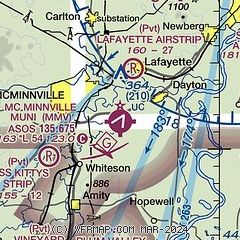
| Sectional chart |
|---|
|
| Airport distance calculator |
|---|
|
|
| Sunrise and sunset |
|---|
|
Times for 20-Sep-2024
| | Local
(UTC-7) | | Zulu
(UTC) |
|---|
| Morning civil twilight | | 06:30 | | 13:30 |
| Sunrise | | 06:59 | | 13:59 |
| Sunset | | 19:12 | | 02:12 |
| Evening civil twilight | | 19:41 | | 02:41 |
|
| Current date and time |
|---|
| Zulu (UTC) | 21-Sep-2024 03:07:06 |
|---|
| Local (UTC-7) | 20-Sep-2024 20:07:06 |
|---|
|
| METAR |
|---|
| KMMV | 210253Z AUTO 02004KT 10SM CLR 17/07 A3015 RMK AO2 SLP207 T01670067 53014
|
KUAO
16nm E | 210253Z 34007KT 10SM CLR 17/07 A3016 RMK AO2 SLP211 T01720072 53013
|
KSLE
19nm S | 210256Z 31007KT 10SM CLR 18/07 A3013 RMK AO2 SLP204 T01780072 53010
|
|
| TAF |
|---|
KUAO
16nm E | 201720Z 2018/2118 01004KT P6SM SKC
|
KSLE
19nm S | 201720Z 2018/2118 36004KT P6SM SKC
|
|
| NOTAMs |
|---|
NOTAMs are issued by the DoD/FAA and will open in a separate window not controlled by AirNav.
|
|


