FAA INFORMATION EFFECTIVE 19 MARCH 2026
Location
| FAA Identifier: | FWN |
| Lat/Long: | 41-12-00.7700N 074-37-22.9270W
41-12.012833N 074-37.382117W
41.2002139,-74.6230353
(estimated) |
| Elevation: | 421.6 ft. / 128.5 m (surveyed) |
| Variation: | 13W (1995) |
| From city: | 1 mile SW of SUSSEX, NJ |
| Time zone: | UTC -4 (UTC -5 during Standard Time) |
| Zip code: | 07461 |
Airport Operations
| Airport use: | Open to the public |
| Activation date: | 05/1945 |
| Control tower: | no |
| ARTCC: | NEW YORK CENTER |
| FSS: | MILLVILLE FLIGHT SERVICE STATION |
| NOTAMs facility: | MIV (NOTAM-D service available) |
| Attendance: | 0830-1700 |
| Wind indicator: | lighted |
| Segmented circle: | no |
| Lights: | DUSK-DAWN. ACTVT MIRL RWY 03/21 - CTAF. |
| Beacon: | white-green (lighted land airport)
Operates sunset to sunrise. |
| Landing fee: | yes |
Airport Communications
| CTAF/UNICOM: | 122.7 |
| WX ASOS: | 118.525 (973-970-3780) |
| NEWARK APPROACH: | 123.775 ;SFC TO 7000 FT |
| NEWARK DEPARTURE: | 123.775 ;SFC TO 7000 FT |
| WX ASOS at 12N (13 nm SW): | PHONE 609-325-2295 |
Nearby radio navigation aids
| VOR radial/distance | | VOR name | | Freq | | Var |
|---|
| SAXr345/8.8 | | SPARTA VORTAC | | 115.70 | | 11W |
| HUOr197/12.6 | | HUGUENOT VOR/DME | | 116.10 | | 11W |
| STWr053/16.6 | | STILLWATER VOR/DME | | 109.60 | | 11W |
| BWZr031/25.7 | | BROADWAY VOR/DME | | 114.20 | | 11W |
| TEBr321/33.0 | | TETERBORO VOR/DME | | 108.40 | | 11W |
| SBJr018/37.4 | | SOLBERG VOR/DME | | 112.90 | | 10W |
| NDB name | | Hdg/Dist | | Freq | | Var | | ID |
|---|
| STANWYCK | | 245/32.6 | | 261 | | 12W | | SKU | ... -.- ..- |
Airport Services
| Fuel available: | 100LL JET-A
A:SELF-SVC. |
| Parking: | tiedowns |
| Airframe service: | NONE |
| Powerplant service: | NONE |
| Bottled oxygen: | NONE |
| Bulk oxygen: | NONE |
Runway Information
Runway 3/21
| Dimensions: | 3506 x 75 ft. / 1069 x 23 m |
| Surface: | asphalt, in good condition |
| Runway edge lights: | medium intensity |
| RUNWAY 3 | | RUNWAY 21 |
| Latitude: | 41-11.735062N | | 41-12.290617N |
| Longitude: | 074-37.486123W | | 074-37.278088W |
| Elevation: | 421.1 ft. | | 401.0 ft. |
| Traffic pattern: | left | | left |
| Runway heading: | 029 magnetic, 016 true | | 209 magnetic, 196 true |
| Displaced threshold: | 466 ft. | | 756 ft. |
| Markings: | basic, in good condition | | basic, in good condition |
| Visual slope indicator: | 2-light PAPI on left (4.00 degrees glide path)
RWY 03 PAPI OTS INDEFLY. | | |
| Runway end identifier lights: | yes
RWY 03 REIL OTS INDEFLY. | | yes
RWY 21 REIL OTS INDEFLY. |
| Touchdown point: | yes, no lights | | yes, no lights |
| Obstructions: | 50 ft. trees, 250 ft. from runway, 260 ft. right of centerline, 1:1 slope to clear
15 FT TREE, 38 FT FM RWY END, 176 FT RIGHT. | | 69 ft. trees, 375 ft. from runway, 79 ft. right of centerline, 2:1 slope to clear
10 FT SIGN, 41 FT FM RWY END, 44 FT RIGHT. |
Airport Ownership and Management from official FAA records
| Ownership: | Privately-owned |
| Owner: | SUSSEX AVIATION LLC
PO BOX 311
SUSSEX, NJ 07461
Phone (973) 702-1640 |
| Manager: | JOHN MASSARI
PO BOX 311
SUSSEX, NJ 07461
Phone (973) 702-1640 |
Additional Remarks
| - | PAJA, DROP ZONE LCTD SW SIDE OF RWY. |
| - | NO TGL OR PLA ALLOWED. |
| - | NON-STD TWY WIDTH, TWY AND RWY MRKGS. AIRCRAFT OPNS ON BLACKTOP ONLY. |
| - | MAIN TWY SW 1500 FT CLSD. |
| - | FOR CD CTC NEWARK APCH AT 800-645-3206. |
| - | DEER AND BIRDS ON AND INVOF ARPT. |
Instrument Procedures
NOTE: All procedures below are presented as PDF files. If you need a reader for these files, you should download the free Adobe Reader.NOT FOR NAVIGATION. Please procure official charts for flight.
FAA instrument procedures published for use from 19 March 2026 at 0901Z to 16 April 2026 at 0900Z.
IAPs - Instrument Approach Procedures |
|---|
| RNAV (GPS) RWY 03 | |
download (198KB) |
| NOTE: Special Alternate Minimums apply | |
download (144KB) |
| NOTE: Special Take-Off Minimums/Departure Procedures apply | |
download |
Other nearby airports with instrument procedures:
12N - Aeroflex/Andover Airport (13 nm SW)
4N1 - Greenwood Lake Airport (13 nm E)
06N - Randall Airport (17 nm NE)
N07 - Lincoln Park Airport (21 nm SE)
1N7 - Blairstown Airport (22 nm SW)
|
|

Road maps at:
MapQuest
Bing
Google
| Aerial photo |
|---|
WARNING: Photo may not be current or correct
 Photo taken 28-Jan-2007
Do you have a better or more recent aerial photo of Sussex Airport that you would like to share? If so, please send us your photo.
|
| Sectional chart |
|---|
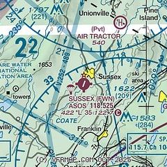
|
| Airport distance calculator |
|---|
|
|
| Sunrise and sunset |
|---|
|
Times for 14-Apr-2026
| | Local
(UTC-4) | | Zulu
(UTC) |
|---|
| Morning civil twilight | | 05:53 | | 09:53 |
| Sunrise | | 06:22 | | 10:22 |
| Sunset | | 19:36 | | 23:36 |
| Evening civil twilight | | 20:05 | | 00:05 |
|
| Current date and time |
|---|
| Zulu (UTC) | 14-Apr-2026 13:11:03 |
|---|
| Local (UTC-4) | 14-Apr-2026 09:11:03 |
|---|
|
| METAR |
|---|
| KFWN | 141253Z AUTO 00000KT 10SM CLR 19/16 A3001 RMK AO2 SLP159 T01890156 $
|
K12N
12nm SW | 141254Z AUTO 20005KT 20/14 A3001 RMK AO1 SLP157 T02000144
|
|
| TAF |
|---|
KSWF
30nm NE | 141145Z 1412/1518 26004KT P6SM SCT250 FM141400 25007KT P6SM SCT250 FM141600 24011KT P6SM FEW045 FEW120 FM141800 25016G23KT P6SM SCT050 SCT080 PROB30 1420/1422 3SM -TSRA BKN045CB FM142300 26012G20KT P6SM SCT050 SCT120 FM150100 27009KT P6SM SCT120 SCT250 FM150400 27005KT P6SM SCT250 FM150600 25005KT 5SM BR SCT250 AMD NOT SKED
|
KTEB
33nm SE | 141140Z 1412/1518 VRB03KT P6SM SCT250 FM141400 22005KT P6SM SCT250 FM141600 22009KT P6SM FEW050 FEW250 FM141800 23014G22KT P6SM FEW060 FEW250 FM150000 23010KT P6SM SCT050 SCT150 FM150300 25006KT P6SM SCT250 FM150600 VRB03KT 5SM BR SCT250 TEMPO 1508/1511 2SM BR
|
KEWR
37nm SE | 141140Z 1412/1518 23007KT P6SM FEW100 SCT250 FM141600 22011G18KT P6SM FEW060 SCT250 FM141800 23015G23KT P6SM FEW060 SCT250 FM150000 24013KT P6SM SCT050 SCT150 FM150200 24010KT P6SM SCT250 FM150600 24006KT P6SM SCT250
|
|
| NOTAMs |
|---|
NOTAMs are issued by the DoD/FAA and will open in a separate window not controlled by AirNav.
|
|


