FAA INFORMATION EFFECTIVE 30 OCTOBER 2025
Location
| FAA Identifier: | N07 |
| Lat/Long: | 40-56-51.4610N 074-18-52.2400W
40-56.857683N 074-18.870667W
40.9476281,-74.3145111
(estimated) |
| Elevation: | 181 ft. / 55.2 m (surveyed) |
| Variation: | 13W (1995) |
| From city: | 2 miles N of LINCOLN PARK, NJ |
| Time zone: | UTC -5 (UTC -4 during Daylight Saving Time) |
| Zip code: | 07035 |
Airport Operations
| Airport use: | Open to the public |
| Activation date: | 01/1939 |
| Control tower: | no |
| ARTCC: | NEW YORK CENTER |
| FSS: | MILLVILLE FLIGHT SERVICE STATION |
| NOTAMs facility: | MIV (NOTAM-D service available) |
| Attendance: | MON-FRI 0900-DUSK, ALL SAT-SUN UNATT |
| Wind indicator: | yes |
| Segmented circle: | no |
| Lights: | ACTVT HIRL RY 01/19 - CTAF. ACTVT HIGH INTST FST WITH 7 CLICKS BFR ACTVTNG LOWER INTSTS. |
| Beacon: | white-green (lighted land airport)
Operates sunset to sunrise. |
Airport Communications
| CTAF/UNICOM: | 122.8 |
| NEWARK APPROACH: | 127.6 |
| NEWARK DEPARTURE: | 127.6 |
| WX ASOS at CDW (5 nm S): | 135.5 (973-575-4417) |
| WX AWOS-3 at MMU (10 nm SW): | PHONE 973-290-0135 |
| WX ASOS at TEB (13 nm SE): | PHONE 201-473-3130 |
| WX ASOS at EWR (17 nm SE): | PHONE 862-381-4743 |
| WX ASOS at 12N (20 nm W): | PHONE 609-325-2295 |
Nearby radio navigation aids
| VOR radial/distance | | VOR name | | Freq | | Var |
|---|
| SAXr136/12.4 | | SPARTA VORTAC | | 115.70 | | 11W |
| TEBr308/12.9 | | TETERBORO VOR/DME | | 108.40 | | 11W |
| LGAr308/22.5 | | LA GUARDIA VOR/DME | | 113.10 | | 12W |
| BWZr080/24.7 | | BROADWAY VOR/DME | | 114.20 | | 11W |
| STWr108/25.3 | | STILLWATER VOR/DME | | 109.60 | | 11W |
| CRIr327/27.7 | | CANARSIE VOR/DME | | 112.30 | | 11W |
| SBJr052/29.2 | | SOLBERG VOR/DME | | 112.90 | | 10W |
| HUOr167/30.4 | | HUGUENOT VOR/DME | | 116.10 | | 11W |
| JFKr319/31.1 | | KENNEDY VOR/DME | | 115.90 | | 12W |
| CMKr251/38.7 | | CARMEL VOR/DME | | 116.60 | | 12W |
| COLr001/38.8 | | COLTS NECK VOR/DME | | 115.40 | | 11W |
| NDB name | | Hdg/Dist | | Freq | | Var | | ID |
|---|
| STANWYCK | | 211/36.9 | | 261 | | 12W | | SKU | ... -.- ..- |
Airport Services
| Fuel available: | 100LL JET-A |
| Parking: | tiedowns |
| Airframe service: | MAJOR |
| Powerplant service: | MAJOR |
| Bottled oxygen: | LOW |
| Bulk oxygen: | NONE |
Runway Information
Runway 1/19
| Dimensions: | 2767 x 40 ft. / 843 x 12 m |
| Surface: | asphalt, in good condition |
| Runway edge lights: | high intensity |
| RUNWAY 1 | | RUNWAY 19 |
| Latitude: | 40-56.630573N | | 40-57.084782N |
| Longitude: | 074-18.846530W | | 074-18.894805W |
| Elevation: | 177.0 ft. | | 180.6 ft. |
| Traffic pattern: | left | | left |
| Runway heading: | 008 magnetic, 355 true | | 188 magnetic, 175 true |
| Displaced threshold: | 690 ft. | | 95 ft. |
| Markings: | nonprecision, in good condition | | nonprecision, in good condition |
| Visual slope indicator: | | | 2-light PAPI on left (4.00 degrees glide path) |
| Touchdown point: | yes, no lights | | yes, no lights |
| Obstructions: | 50 ft. trees, 200 ft. from runway, 60 ft. right of centerline
+75 FT TREES 0-200 FT FROM RWY END 250 L - 250 R. | | 20 ft. stack, 260 ft. from runway, 155 ft. left of centerline, 3:1 slope to clear
+30 FT HGR 80 FT FROM RWY END 200 FT L. |
Airport Ownership and Management from official FAA records
| Ownership: | Privately-owned |
| Owner: | LINCOLN PARK AIRPORT INC
425 BEAVER BROOK ROAD
LINCOLN PARK, NJ 07035
Phone 973-628-7166 |
| Manager: | TOM VAN WINGERDEN
425 BEAVER BROOK ROAD
LINCOLN PARK, NJ 07035
Phone 973-628-7166 |
Additional Remarks
| - | NARROW TAXILANES & TWYS CAUSED BY NSTD CLNCS. |
| - | DEER AND BIRDS INVOF RUNWAY. |
| - | TOUCH AND GO LANDINGS PROHIBITED. |
| - | GCO AVBL ON FREQ 121.725. IF UNABLE, CTC NEWARK APCH AT 800-645-3206. |
| - | TSNT HEL OPS ALLOWED WITH PRE-APVL ONLY, CALL 973-628-7166. |
| - | (CONTACT TITLE) FBO CTC (973) 633-0450. |
Instrument Procedures
NOTE: All procedures below are presented as PDF files. If you need a reader for these files, you should download the free Adobe Reader.NOT FOR NAVIGATION. Please procure official charts for flight.
FAA instrument procedures published for use from 30 October 2025 at 0901Z to 27 November 2025 at 0900Z.
STARs - Standard Terminal Arrivals |
|---|
| MAZIE THREE (RNAV) | |
download (199KB) |
IAPs - Instrument Approach Procedures |
|---|
| RNAV (GPS) RWY 01 | |
download (183KB) |
| RNAV (GPS) RWY 19 | |
download (184KB) |
| NOTE: Special Take-Off Minimums/Departure Procedures apply | |
download (438KB) |
Other nearby airports with instrument procedures:
KCDW - Essex County Airport (5 nm S)
KMMU - Morristown Municipal Airport (10 nm SW)
4N1 - Greenwood Lake Airport (11 nm N)
KTEB - Teterboro Airport (13 nm SE)
KEWR - Newark Liberty International Airport (17 nm SE)
KJRA - West 30th St Heliport (18 nm SE)
12N - Aeroflex/Andover Airport (20 nm W)
6N5 - East 34th Street Heliport (20 nm SE)
|
|

Road maps at:
MapQuest
Bing
Google
| Aerial photo |
|---|
WARNING: Photo may not be current or correct
 Photo by Trey Buttriss pleasureandplane.com
Photo taken 24-Jul-2011
looking southeast.
Photo by Trey Buttriss pleasureandplane.com
Photo taken 24-Jul-2011
looking southeast.
Do you have a better or more recent aerial photo of Lincoln Park Airport that you would like to share? If so, please send us your photo.
|
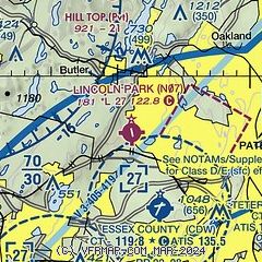
| Sectional chart |
|---|
|
| Airport distance calculator |
|---|
|
|
| Sunrise and sunset |
|---|
|
Times for 27-Nov-2025
| | Local
(UTC-5) | | Zulu
(UTC) |
|---|
| Morning civil twilight | | 06:29 | | 11:29 |
| Sunrise | | 06:59 | | 11:59 |
| Sunset | | 16:30 | | 21:30 |
| Evening civil twilight | | 17:01 | | 22:01 |
|
| Current date and time |
|---|
| Zulu (UTC) | 27-Nov-2025 07:36:06 |
|---|
| Local (UTC-5) | 27-Nov-2025 02:36:06 |
|---|
|
| METAR |
|---|
KCDW
4nm S | 270653Z AUTO 28009G15KT 10SM CLR 07/M04 A2985 RMK AO2 SLP113 T00671044
|
KMMU
11nm SW | 270715Z AUTO 26006G17KT 10SM CLR 05/M05 A2986 RMK AO2
|
KTEB
13nm E | 270651Z 27007G17KT 10SM CLR 06/M03 A2984 RMK AO2 SLP103 T00611033
|
KEWR
17nm SE | 270651Z 26016G26KT 10SM BKN110 07/M06 A2986 RMK AO2 PK WND 26028/0608 SLP110 T00671056 $
|
KNYC
19nm SE | 270651Z AUTO VRB06G17KT 10SM CLR 07/M04 A2986 RMK AO2 SLP103 T00671039
|
K12N
19nm W | 270654Z AUTO VRB05G21KT 04/M06 A2985 RMK AO1 SLP112 T00441056
|
|
| TAF |
|---|
KTEB
13nm E | 270520Z 2706/2812 27012G22KT P6SM SCT050 TEMPO 2706/2707 27030G40KT FM271600 27015G28KT P6SM BKN050 FM272200 27012G20KT P6SM FEW050 SCT150 FM280300 26011KT P6SM SCT050
|
KEWR
17nm SE | 270520Z 2706/2812 26014G23KT P6SM SCT050 TEMPO 2706/2707 27030G40KT FM271600 27017G29KT P6SM BKN050 FM272200 26015G22KT P6SM FEW050 SCT150 FM280300 25011G16KT P6SM SCT050
|
|
| NOTAMs |
|---|
NOTAMs are issued by the DoD/FAA and will open in a separate window not controlled by AirNav.
|
|

