FAA INFORMATION EFFECTIVE 09 JULY 2026
Location
| FAA Identifier: | HEG |
| Lat/Long: | 30-16-40.0290N 081-48-21.4040W
30-16.667150N 081-48.356733W
30.2777858,-81.8059456
(estimated) |
| Elevation: | 85.9 ft. / 26.2 m (surveyed) |
| Variation: | 06W (2010) |
| From city: | 8 miles SW of JACKSONVILLE, FL |
| Time zone: | UTC -4 (UTC -5 during Standard Time) |
| Zip code: | 32210 |
Airport Operations
| Airport use: | Open to the public |
| Activation date: | 01/1940 |
| Control tower: | no |
| ARTCC: | JACKSONVILLE CENTER |
| FSS: | GAINESVILLE FLIGHT SERVICE STATION |
| NOTAMs facility: | GNV (NOTAM-D service available) |
| Attendance: | MON-FRI 0630-1930, ALL SAT-SUN 0700-1700 |
| Wind indicator: | lighted |
| Segmented circle: | yes |
| Lights: | ACTVT MIRL RWY 07/25 & 11/29 - CTAF. |
| Beacon: | white-green (lighted land airport)
Operates sunset to sunrise. |
Airport Communications
| CTAF/UNICOM: | 123.0 |
| WX AWOS-3: | 119.275 (904-741-2224) |
| JACKSONVILLE APPROACH: | 127.775 127.775 [0700-2300] |
| JACKSONVILLE DEPARTURE: | 127.775 [0700-2300] |
| WX AWOS-3 at VQQ (5 nm SW): | 125.275 (904-778-6934) |
| WX AWOS-3 at NIP (7 nm E): | 119.275 |
| WX ASOS at JAX (14 nm NE): | 125.85 (904-549-9655) |
| WX ASOS at CRG (16 nm E): | 125.4 (904-646-4670) |
Nearby radio navigation aids
| VOR radial/distance | | VOR name | | Freq | | Var |
|---|
| CRGr260/15.8 | | CRAIG VORTAC | | 114.50 | | 03W |
| NDB name | | Hdg/Dist | | Freq | | Var | | ID |
|---|
| DINNS | | 187/11.2 | | 344 | | 06W | | JA | .--- .- |
| REYNOLDS | | 345/20.2 | | 338 | | 07W | | RYD | .-. -.-- -.. |
Airport Services
| Fuel available: | 100LL JET-A |
| Parking: | hangars and tiedowns |
| Airframe service: | MAJOR |
| Powerplant service: | MAJOR |
| Bottled oxygen: | NONE |
| Bulk oxygen: | NONE |
Runway Information
Runway 7/25
| Dimensions: | 4001 x 100 ft. / 1220 x 30 m |
| Surface: | asphalt, in fair condition |
| Weight bearing capacity: | | PCN 11 /F/B/Y/T | | Single wheel: | 30.0 |
|
| Runway edge lights: | medium intensity |
| RUNWAY 7 | | RUNWAY 25 |
| Latitude: | 30-16.581585N | | 30-16.864010N |
| Longitude: | 081-48.894763W | | 081-48.207532W |
| Elevation: | 73.4 ft. | | 79.9 ft. |
| Traffic pattern: | left | | left |
| Runway heading: | 071 magnetic, 065 true | | 251 magnetic, 245 true |
| Markings: | basic, in good condition | | nonprecision, in good condition |
| Visual slope indicator: | 2-light PAPI on left (3.00 degrees glide path) | | 2-light PAPI on left (3.00 degrees glide path) |
| Touchdown point: | yes, no lights | | yes, no lights |
| Obstructions: | 50 ft. tree, 1395 ft. from runway, 210 ft. right of centerline, 24:1 slope to clear | | 60 ft. trees, 2215 ft. from runway, 50 ft. right of centerline, 34:1 slope to clear |
Runway 11/29
| Dimensions: | 3500 x 100 ft. / 1067 x 30 m |
| Surface: | asphalt, in good condition |
| Weight bearing capacity: | | PCN 6 /F/B/Y/T | | Single wheel: | 30.0 |
|
| Runway edge lights: | medium intensity |
| RUNWAY 11 | | RUNWAY 29 |
| Latitude: | 30-16.700740N | | 30-16.506312N |
| Longitude: | 081-48.447685W | | 081-47.821343W |
| Elevation: | 84.6 ft. | | 82.7 ft. |
| Traffic pattern: | left | | left |
| Runway heading: | 116 magnetic, 110 true | | 296 magnetic, 290 true |
| Markings: | basic, in good condition | | basic, in good condition |
| Visual slope indicator: | 2-light PAPI on left (3.00 degrees glide path) | | 2-light PAPI on left (3.00 degrees glide path) |
| Touchdown point: | yes, no lights | | yes, no lights |
| Obstructions: | 76 ft. trees, 2235 ft. from runway, 27:1 slope to clear | | 50 ft. trees, 1035 ft. from runway, 65 ft. right of centerline, 20:1 slope to clear |
Airport Ownership and Management from official FAA records
| Ownership: | Publicly-owned |
| Owner: | JACKSONVILLE AVIATION AUTHORITY
14201 PECAN PARK ROAD
JACKSONVILLE, FL 32218
Phone 904-741-2069
904-741-2040. |
| Manager: | ROLF RIECHMANN
9300 NORMANDY BLVD., SUITE 4
JACKSONVILLE, FL 32221-5522
Phone 904-783-2805
FBO (904) 783-2805. |
Additional Remarks
| - | ULTRALIGHT & GLIDER ACTIVITY ON & INVOF ARPT. |
| - | GCO AVBL ON FREQ 121.725 THRU JACKSONVILLE ARTCC CD AND GAINESVILLE FSS. |
| - | FOR CD IF UNA VIA GCO CTC JACKSONVILLE ARTCC AT 904-741-0284. |
| - | 24-HOUR PPR FOR ACFT EQUIPPED WITH WEATHER MODIFICATION OR GEOENGINEERING EQPT 904-741-2020. |
Instrument Procedures
NOTE: All procedures below are presented as PDF files. If you need a reader for these files, you should download the free Adobe Reader.NOT FOR NAVIGATION. Please procure official charts for flight.
FAA instrument procedures published for use from 09 July 2026 at 0901Z to 06 August 2026 at 0900Z.
STARs - Standard Terminal Arrivals |
|---|
| QUBEN TWO (RNAV) **NEW** | |
download (163KB) |
IAPs - Instrument Approach Procedures |
|---|
| RNAV (GPS) RWY 25 | |
download (294KB) |
| NOTE: Special Take-Off Minimums/Departure Procedures apply | |
download (162KB) |
Other nearby airports with instrument procedures:
KVQQ - Cecil Airport (5 nm SW)
KNIP - Jacksonville Naval Air Station (Towers Field) (7 nm E)
KJAX - Jacksonville International Airport (14 nm NE)
KCRG - Jacksonville Executive Airport at Craig (16 nm E)
KNRB - Mayport Naval Station (Adm David L. McDonald Field) (21 nm E)
|
|

Road maps at:
MapQuest
Bing
Google
| Aerial photo |
|---|
WARNING: Photo may not be current or correct
 Photo by Michelle Nifong
Taken in November 2009
Photo by Michelle Nifong
Taken in November 2009
Do you have a better or more recent aerial photo of Herlong Recreational Airport that you would like to share? If so, please send us your photo.
|
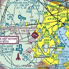
| Sectional chart |
|---|
|
CAUTION: Diagram may not be current

| Airport distance calculator |
|---|
|
|
| Sunrise and sunset |
|---|
|
Times for 25-Jul-2026
| | Local
(UTC-4) | | Zulu
(UTC) |
|---|
| Morning civil twilight | | 06:16 | | 10:16 |
| Sunrise | | 06:42 | | 10:42 |
| Sunset | | 20:25 | | 00:25 |
| Evening civil twilight | | 20:51 | | 00:51 |
|
| Current date and time |
|---|
| Zulu (UTC) | 26-Jul-2026 03:33:29 |
|---|
| Local (UTC-4) | 25-Jul-2026 23:33:29 |
|---|
|
| METAR |
|---|
| KHEG | 260315Z AUTO 00000KT 10SM FEW060 24/24 A3007 RMK AO2 TSNO
|
KNEN
5nm NW | 260253Z AUTO 00000KT 10SM CLR 24/23 A3007 RMK AO2 SLP246 60000 T02440233 53004 $
|
KVQQ
5nm SW | 260315Z AUTO 16003KT 9SM BKN110 24/24 A3005 RMK AO2
|
KNIP
8nm SE | 260253Z 27005KT 10SM SCT170 BKN250 26/24 A3007 RMK AO2 SLP177 60010 T02560239 55001
|
KJAX
15nm NE | 260256Z 19005KT 10SM SCT210 BKN250 25/24 A3004 RMK AO2 SLP172 T02500239 53002 $
|
KCRG
15nm E | 260253Z 22005KT 10SM CLR 26/24 A3006 RMK AO2 SLP177 60002 T02610244 53001
|
|
| TAF |
|---|
KVQQ
5nm SW | 260131Z 2602/2624 VRB03KT P6SM BKN100 OVC250 FM261700 30008KT P6SM VCSH FEW040 SCT100 BKN250 FM262100 27007KT P6SM VCTS SCT040CB BKN100 PROB30 2621/2624 VRB15G30KT 3SM TSRA BKN040CB
|
KNIP
8nm SE | 2523/2623 VRB06KT 9999 VCTS BKN030CB BKN120 QNH2996INS TEMPO 2523/2602 VRB20G30KT 1600 TSRA BR BKN020CB OVC100 BECMG 2602/2603 27008KT 9999 NSW SCT050 BKN150 BKN250 QNH2998INS FM261200 27008KT 9999 FEW080 SCT130 QNH2995INS BECMG 2617/2618 9999 VCTS SCT030 BKN080CB BKN120 QNH2992INS TEMPO 2618/2623 1600 TSRA BR BKN025CB OVC080 AUTOMATED SENSOR METWATCH 2523 TIL 2607 TX34/2618Z TN24/2606Z FN00328
|
KJAX
15nm NE | 260131Z 2602/2624 VRB03KT P6SM OVC250 FM261700 30008KT P6SM VCSH FEW040 SCT100 BKN250 FM262100 27007KT P6SM VCTS SCT040CB BKN100 PROB30 2621/2624 VRB15G30KT 3SM TSRA BKN040CB
|
KCRG
15nm E | 260131Z 2602/2624 VRB03KT P6SM OVC250 FM261500 30007KT P6SM FEW040 SCT100 BKN250 FM262000 27007KT P6SM VCTS SCT040CB BKN100 PROB30 2621/2624 VRB15G30KT 3SM TSRA BKN040CB
|
|
| NOTAMs |
|---|
NOTAMs are issued by the DoD/FAA and will open in a separate window not controlled by AirNav.
|
|


