FAA INFORMATION EFFECTIVE 09 JULY 2026
Location
| FAA Identifier: | MWO |
| Lat/Long: | 39-31-54.3000N 084-23-47.2000W
39-31.905000N 084-23.786667W
39.5317500,-84.3964444
(estimated) |
| Elevation: | 650.6 ft. / 198.3 m (surveyed) |
| Variation: | 04W (1985) |
| From city: | 2 miles N of MIDDLETOWN, OH |
| Time zone: | UTC -4 (UTC -5 during Standard Time) |
| Zip code: | 45042 |
Airport Operations
| Airport use: | Open to the public |
| Activation date: | 01/1946 |
| Control tower: | no |
| ARTCC: | INDIANAPOLIS CENTER |
| FSS: | DAYTON FLIGHT SERVICE STATION |
| NOTAMs facility: | MWO (NOTAM-D service available) |
| Attendance: | 0700-1900 |
| Wind indicator: | lighted |
| Segmented circle: | no |
| Lights: | ACTVT REIL RWY 05 & 23; MIRL RWY 05/23 - CTAF. PAPI RWY 05 & 23 OPR CONSLY. |
| Beacon: | white-green (lighted land airport)
Operates sunset to sunrise. |
Airport Communications
| CTAF/UNICOM: | 123.0 |
| WX AWOS-3PT: | 120.025 (513-422-3505) |
| COLUMBUS APPROACH: | 118.85 |
| COLUMBUS DEPARTURE: | 118.85 |
| DANEI STAR: | 134.45 |
| WX AWOS-3PT at I68 (8 nm SE): | 120.55 (513-934-5500) |
| WX ASOS at MGY (9 nm NE): | 118.375 (937-885-2171) |
| WX ASOS at HAO (12 nm SW): | 121.425 (513-863-6137) |
| WX AWOS-3PT at OXD (18 nm W): | 118.625 (513-273-2032) |
Nearby radio navigation aids
| VOR radial/distance | | VOR name | | Freq | | Var |
|---|
| MXQr287/28.2 | | MIDWEST VOR/DME | | 112.90 | | 04W |
| DQNr181/29.1 | | DAYTON VOR/DME | | 114.50 | | 01W |
| NDB name | | Hdg/Dist | | Freq | | Var | | ID |
|---|
| ONIDA | | 234/4.4 | | 223 | | 04W | | MW | -- .-- |
| SPORTYS | | 347/28.6 | | 245 | | 04W | | PWF | .--. .-- ..-. |
Airport Services
| Fuel available: | 100LL JET-A+
A+:FOR FUEL AFT HRS CALL 513-425-7845. |
| Parking: | hangars and tiedowns |
| Airframe service: | MAJOR |
| Powerplant service: | MAJOR |
| Bottled oxygen: | LOW |
| Bulk oxygen: | NONE |
Runway Information
Runway 5/23
| Dimensions: | 6100 x 100 ft. / 1859 x 30 m |
| Surface: | asphalt, in good condition |
| Weight bearing capacity: | | Single wheel: | 66.0 | | Double wheel: | 78.0 | | Double tandem: | 140.0 |
|
| Runway edge lights: | medium intensity |
| RUNWAY 5 | | RUNWAY 23 |
| Latitude: | 39-31.534472N | | 39-32.187810N |
| Longitude: | 084-24.210283W | | 084-23.224447W |
| Elevation: | 641.8 ft. | | 650.3 ft. |
| Traffic pattern: | left | | right |
| Runway heading: | 053 magnetic, 049 true | | 233 magnetic, 229 true |
| Displaced threshold: | no | | 299 ft. |
| Markings: | nonprecision, in fair condition | | nonprecision, in fair condition |
| Visual slope indicator: | 4-light PAPI on left (3.00 degrees glide path) | | 4-light PAPI on left (3.00 degrees glide path) |
| Runway end identifier lights: | yes | | yes |
| Touchdown point: | yes, no lights | | yes, no lights |
| Instrument approach: | | | LOCALIZER |
| Obstructions: | 30 ft. trees, 771 ft. from runway, 236 ft. left of centerline, 19:1 slope to clear | | 40 ft. tree, 885 ft. from runway, 300 ft. left of centerline, 17:1 slope to clear
OBSTN CLNC SLP 33:1 TO DTHR. |
Runway 8/26
| Dimensions: | 3026 x 160 ft. / 922 x 49 m |
| Surface: | turf, in good condition |
| Runway edge markings: | WHITE CONES. |
| RUNWAY 8 | | RUNWAY 26 |
| Latitude: | 39-31.969808N | | 39-32.011942N |
| Longitude: | 084-24.247340W | | 084-23.606045W |
| Elevation: | 643.0 ft. | | 644.4 ft. |
| Traffic pattern: | left | | right |
| Runway heading: | 089 magnetic, 085 true | | 269 magnetic, 265 true |
| Displaced threshold: | 951 ft. | | no |
| Runway end identifier lights: | no | | no |
| Touchdown point: | yes, no lights | | yes, no lights |
| Obstructions: | 95 ft. trees, 771 ft. from runway, 170 ft. right of centerline, 8:1 slope to clear
OBSTN CLNC SLP 18:1 TO DTHR. | | none |
Airport Ownership and Management from official FAA records
| Ownership: | Publicly-owned |
| Owner: | CITY OF MIDDLETOWN
1 DONHAM PLZ
MIDDLETOWN, OH 45042-1932
Phone 513-425-7845 |
| Manager: | NIKOLAS BRUMBACK
1 DONHAM PLZ
MIDDLETOWN, OH 45042-1932
Phone 513-705-1777
CELL 513-236-3238. |
Additional Remarks
| - | FOR CD CTC COLUMBUS APCH AT 614-338-8537. |
| - | EXTSV PAJA. |
| - | DEER, BIRDS, & OTR WILDLIFE ON & INVOF ARPT. |
| - | ULTRALIGHTS ENTER/EXIT RWY 08 TFC PAT FM/TO THE NORTH AT LWR THAN RGLR TPA. ULTRALIGHTS DO NOT FLY SOUTH OF RWY 26. |
Instrument Procedures
NOTE: All procedures below are presented as PDF files. If you need a reader for these files, you should download the free Adobe Reader.NOT FOR NAVIGATION. Please procure official charts for flight.
FAA instrument procedures published for use from 09 July 2026 at 0901Z to 06 August 2026 at 0900Z.
STARs - Standard Terminal Arrivals |
|---|
| DANEI THREE **NEW** | |
download (157KB) |
IAPs - Instrument Approach Procedures |
|---|
| RNAV (GPS) RWY 05 | |
download (220KB) |
| RNAV (GPS) RWY 23 | |
download (243KB) |
| LOC RWY 23 | |
download (217KB) |
| NOTE: Special Alternate Minimums apply | |
download (144KB) |
| NOTE: Special Take-Off Minimums/Departure Procedures apply | |
download (458KB) |
Other nearby airports with instrument procedures:
I68 - Warren County Airport/John Lane Field (8 nm SE)
KMGY - Dayton/Wright Brothers Airport (9 nm NE)
I73 - Moraine Air Park (12 nm NE)
KHAO - Butler County Regional Airport/Hogan Field (12 nm SW)
KOXD - Miami University Airport (18 nm W)
|
|

Road maps at:
MapQuest
Bing
Google
| Aerial photo |
|---|
WARNING: Photo may not be current or correct
 Photo taken 27-May-2006
from FL190
Photo taken 27-May-2006
from FL190
Do you have a better or more recent aerial photo of Middletown Regional Airport/Hook Field that you would like to share? If so, please send us your photo.
|
| Sectional chart |
|---|
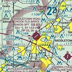
|
| Airport distance calculator |
|---|
|
|
| Sunrise and sunset |
|---|
|
Times for 27-Jul-2026
| | Local
(UTC-4) | | Zulu
(UTC) |
|---|
| Morning civil twilight | | 06:03 | | 10:03 |
| Sunrise | | 06:34 | | 10:34 |
| Sunset | | 20:55 | | 00:55 |
| Evening civil twilight | | 21:25 | | 01:25 |
|
| Current date and time |
|---|
| Zulu (UTC) | 27-Jul-2026 04:01:36 |
|---|
| Local (UTC-4) | 27-Jul-2026 00:01:36 |
|---|
|
| METAR |
|---|
| KMWO | 270355Z AUTO 00000KT 2SM BR CLR 20/20 A2993 RMK AO2 VIS 3/4V5
|
KI68
8nm SE | 270355Z AUTO 00000KT 10SM FEW003 OVC065 21/21 A2992 RMK AO2
|
KMGY
9nm NE | 270353Z AUTO 00000KT 10SM CLR 21/20 A2993 RMK AO2 SLP127 T02110200 $
|
KHAO
11nm SW | 270353Z AUTO 00000KT 7SM CLR 19/19 A2992 RMK AO2 SLP127 T01940194
|
KOXD
18nm W | 270355Z AUTO 00000KT 10SM CLR 21/21 A2993 RMK AO2 T02140208
|
|
| TAF |
|---|
KDAY
24nm N | 261735Z 2618/2718 29006KT P6SM BKN024 FM261900 29007KT P6SM BKN035 FM270100 23004KT P6SM SCT250 FM271400 24007KT P6SM SCT035
|
KFFO
24nm NE | 261900Z 2619/2801 27009KT 9999 BKN030 QNH2988INS BECMG 2623/2624 VRB06KT 9999 FEW040 QNH2986INS BECMG 2714/2715 22012KT 9999 FEW120 SCT200 510102 QNH2969INS TEMPO 2716/2724 21015G25KT BECMG 2723/2724 23015G25KT 8000 -SHRA BKN040 OVC080 520103 QNH2968INS TX28/2621Z TN20/2711Z
|
KLUK
26nm S | 262115Z 2621/2718 29004KT P6SM BKN035 FM270000 34004KT P6SM SCT250 FM270800 00000KT 3SM BR SCT250 TEMPO 2708/2712 1SM BR SCT003 FM271200 00000KT P6SM SCT035
|
KILN
28nm E | 261735Z 2618/2718 29006KT P6SM BKN024 FM261900 29007KT P6SM BKN035 FM270200 24004KT P6SM SCT250 FM270800 00000KT 3SM BR SCT250 TEMPO 2708/2712 2SM BR FM271200 24006KT P6SM SCT035
|
|
| NOTAMs |
|---|
NOTAMs are issued by the DoD/FAA and will open in a separate window not controlled by AirNav.
|
|


