FAA INFORMATION EFFECTIVE 30 OCTOBER 2025
Location
| FAA Identifier: | N72 |
| Lat/Long: | 41-17-15.3370N 074-17-13.5410W
41-17.255617N 074-17.225683W
41.2875936,-74.2870947
(estimated) |
| Elevation: | 540 ft. / 164.6 m (surveyed) |
| Variation: | 13W (1985) |
| From city: | 3 miles NE of WARWICK, NY |
| Time zone: | UTC -5 (UTC -4 during Daylight Saving Time) |
| Zip code: | 10990 |
Airport Operations
| Airport use: | Open to the public |
| Activation date: | 01/1940 |
| Control tower: | no |
| ARTCC: | NEW YORK CENTER |
| FSS: | NEW YORK FLIGHT SERVICE STATION |
| NOTAMs facility: | ISP (NOTAM-D service available) |
| Attendance: | IREG |
| Wind indicator: | yes |
| Segmented circle: | no |
| Lights: | ACTVT LIRL RWY 03R/21L - CTAF. |
Airport Communications
| CTAF/UNICOM: | 123.0 |
| WX ASOS at MGJ (13 nm N): | 119.275 (845-457-1486) |
| WX ASOS at FWN (16 nm W): | 118.525 (973-875-0859) |
Nearby radio navigation aids
| VOR radial/distance | | VOR name | | Freq | | Var |
|---|
| HUOr129/15.5 | | HUGUENOT VOR/DME | | 116.10 | | 11W |
| SAXr052/17.4 | | SPARTA VORTAC | | 115.70 | | 11W |
| TEBr350/28.2 | | TETERBORO VOR/DME | | 108.40 | | 11W |
| IGNr235/30.8 | | KINGSTON VOR/DME | | 117.60 | | 12W |
| STWr067/31.6 | | STILLWATER VOR/DME | | 109.60 | | 11W |
| CMKr283/31.8 | | CARMEL VOR/DME | | 116.60 | | 12W |
| LGAr340/35.7 | | LA GUARDIA VOR/DME | | 113.10 | | 12W |
| BWZr051/38.0 | | BROADWAY VOR/DME | | 114.20 | | 11W |
| NDB name | | Hdg/Dist | | Freq | | Var | | ID |
|---|
| NEELY | | 207/12.2 | | 335 | | 14W | | SW | ... .-- |
| STANWYCK | | 229/18.1 | | 261 | | 12W | | SKU | ... -.- ..- |
Airport Services
| Fuel available: | 100LL
100LL:SELF SVC FUEL AVBL. |
| Parking: | tiedowns |
| Airframe service: | NONE |
| Powerplant service: | NONE |
| Bottled oxygen: | NONE |
| Bulk oxygen: | NONE |
Runway Information
Runway 3R/21L
| Dimensions: | 2150 x 28 ft. / 655 x 9 m |
| Surface: | asphalt, in good condition |
| Runway edge lights: | non-standard
RWY 03R/21L NSTD LIRL HAS SPACING 400 FT APART. |
| RUNWAY 3R | | RUNWAY 21L |
| Traffic pattern: | left | | left |
| Markings: | numbers only, in good condition | | numbers only, in good condition |
| Runway end identifier lights: | no | | no |
| Obstructions: | 93 ft. tree, 1249 ft. from runway, 65 ft. right of centerline, 11:1 slope to clear
RWY 03R 35 FT TREES 22 FT FM THR 95 FT RIGHT. | | 61 ft. trees, 694 ft. from runway, 8:1 slope to clear
RWY 21L 38 FT TREES 170 FT FM THR 90 FT LEFT. |
Runway 8/26
| Dimensions: | 2250 x 80 ft. / 686 x 24 m |
| Surface: | turf, in good condition |
| RUNWAY 8 | | RUNWAY 26 |
| Traffic pattern: | left | | left |
| Runway end identifier lights: | no | | no |
| Obstructions: | 60 ft. tree, 77 ft. from runway, 64 ft. left of centerline, 1:1 slope to clear | | 52 ft. tree, 158 ft. from runway, 99 ft. right of centerline, 3:1 slope to clear |
Runway 3L/21R
| Dimensions: | 2100 x 50 ft. / 640 x 15 m |
| Surface: | turf, in good condition |
| RUNWAY 3L | | RUNWAY 21R |
| Traffic pattern: | left | | left |
| Obstructions: | 68 ft. trees, 117 ft. left of centerline | | 56 ft. trees, 38 ft. from runway, 54 ft. right of centerline |
Airport Ownership and Management from official FAA records
| Ownership: | Publicly-owned |
| Owner: | TOWN OF WARWICK
BOX 489
WARWICK, NY 10990
Phone 845-986-9544 |
| Manager: | JEFF WALKER
41 AIRPORT RD
WARWICK, NY 10990
Phone 845-258-0183 |
Additional Remarks
| - | ARPT CLSD TO TSNT ACFT SS-SR. |
| - | PRACTICE LDGS NA. |
| - | MTS & TWRS IN CLOSE VCNTY OF ARPT. |
| - | RWY 08 HAS 6 FT CHAIN LINK FENCE, 58 FT LEFT, PARLTO RWY. |
| - | FOR CD CTC NEW YORK APCH AT 516-683-2448. |
| - | DEER AND BIRD ACT NEAR MOVEMENT AREAS. |
| - | SEAPLANE USE OF WICKHAM LAKE PROHIBITED. |
Instrument Procedures
There are no published instrument procedures at N72.
Some nearby airports with instrument procedures:
06N - Randall Airport (10 nm NW)
4N1 - Greenwood Lake Airport (10 nm S)
KMGJ - Orange County Airport (13 nm N)
KSWF - New York Stewart International Airport (15 nm NE)
KFWN - Sussex Airport (16 nm W)
|
|

Road maps at:
MapQuest
Bing
Google
| Aerial photo |
|---|
WARNING: Photo may not be current or correct
 Photo taken 17-Aug-2011
looking southwest.
Photo taken 17-Aug-2011
looking southwest.
Do you have a better or more recent aerial photo of Warwick Municipal Airport that you would like to share? If so, please send us your photo.
|
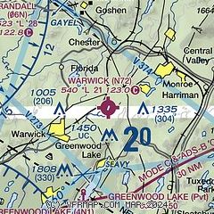
| Sectional chart |
|---|
|
| Airport distance calculator |
|---|
|
|
| Sunrise and sunset |
|---|
|
Times for 21-Nov-2025
| | Local
(UTC-5) | | Zulu
(UTC) |
|---|
| Morning civil twilight | | 06:23 | | 11:23 |
| Sunrise | | 06:53 | | 11:53 |
| Sunset | | 16:33 | | 21:33 |
| Evening civil twilight | | 17:03 | | 22:03 |
|
| Current date and time |
|---|
| Zulu (UTC) | 21-Nov-2025 13:06:05 |
|---|
| Local (UTC-5) | 21-Nov-2025 08:06:05 |
|---|
|
| METAR |
|---|
KMGJ
14nm N | SuperAWOS
211254Z AUTO 00000KT 10SM OVC034 03/M01 A3006 RMK AO2 SLP183 T00281011 $
|
KSWF
16nm NE | 211245Z 00000KT 10SM OVC020 04/01 A3006
|
KFWN
16nm W | 211253Z AUTO 22003KT 4SM HZ BKN013 BKN027 OVC034 06/02 A3008 RMK AO2 SLP189 T00560017
|
KCDW
24nm S | 211253Z 00000KT 10SM OVC016 04/01 A3010 RMK AO2 SLP201 T00440011
|
K12N
26nm SW | 211254Z AUTO 00000KT 05/02 A3008 RMK AO1 SLP195 T00500022
|
KTEB
27nm SE | 211251Z 00000KT 8SM OVC019 06/01 A3009 RMK AO2 SLP189 T00560011 $
|
|
| TAF |
|---|
KSWF
16nm NE | 211130Z 2112/2218 VRB04KT P6SM OVC025 FM211600 25005KT P6SM SCT025 BKN040 FM212300 VRB03KT P6SM OVC040 PROB30 2209/2212 5SM -RA BR BKN015 OVC025 FM221200 32006KT P6SM BKN035 OVC070 FM221500 32009KT P6SM BKN100 AMD NOT SKED
|
|
| NOTAMs |
|---|
NOTAMs are issued by the DoD/FAA and will open in a separate window not controlled by AirNav.
|
|

