FAA INFORMATION EFFECTIVE 27 NOVEMBER 2025
Location
| FAA Identifier: | POC |
| Lat/Long: | 34-05-30.0000N 117-46-54.4000W
34-05.500000N 117-46.906667W
34.0916667,-117.7817778
(estimated) |
| Elevation: | 1013.9 ft. / 309.0 m (surveyed) |
| Variation: | 14E (1980) |
| From city: | 1 mile SW of LA VERNE, CA |
| Time zone: | UTC -8 (UTC -7 during Daylight Saving Time) |
| Zip code: | 91750 |
Airport Operations
| Airport use: | Open to the public |
| Activation date: | 01/1942 |
| Control tower: | yes |
| ARTCC: | LOS ANGELES CENTER |
| FSS: | RIVERSIDE FLIGHT SERVICE STATION |
| NOTAMs facility: | POC (NOTAM-D service available) |
| Attendance: | CONTINUOUS |
| Wind indicator: | lighted |
| Segmented circle: | yes |
| Lights: | WHEN ATCT CLSD, ARPT LGT OPRS CONSLY FM 2100-0700 LCL. |
| Beacon: | white-green (lighted land airport)
Operates sunset to sunrise. |
Airport Communications
| CTAF: | 118.2 |
| UNICOM: | 122.95 |
| WX AWOS-3PT: | PHONE 909-962-5407 |
| BRACKETT GROUND: | 125.0 [0700-2100] |
| BRACKETT TOWER: | 118.2 ;RWY 08R/26L 133.3 ;RWY 08L/26R [0700-2100] |
| SOCAL APPROACH: | 125.5 ;SW-NORTH |
| SOCAL DEPARTURE: | 125.5 ;SW-NORTH |
| CLEARANCE DELIVERY: | 121.875 |
| CLASS C: | 127.0 ;NORTH-NE |
| D-ATIS: | 124.4 |
| IC: | 125.5 ;SW-NORTH |
| SETER STAR: | 127.0 |
| ZIGGY STAR: | 127.0 |
| WX AWOS-3P at CCB (5 nm E): | 119.525 (909-985-4731) |
| WX ASOS at ONT (9 nm E): | PHONE 909-937-2186 |
| WX ASOS at CNO (10 nm SE): | PHONE 909-393-5823 |
| WX AWOS-3PT at EMT (13 nm W): | 118.75 ((626) 444-1107) |
| WX AWOS-3PT at AJO (15 nm SE): | 132.175 (951-340-4764) |
| WX ASOS at FUL (16 nm SW): | PHONE 714-870-1372 |
| WX ASOS at RAL (19 nm SE): | 128.8 (951-352-4392) |
Nearby radio navigation aids
| VOR radial/distance | | VOR name | | Freq | | Var |
|---|
| POM at field | | POMONA VORTAC | | 110.40 | | 15E |
| PDZr295/16.3 | | PARADISE VORTAC | | 112.20 | | 15E |
| RALr282/(18.4) | | RIVERSIDE VOR | | 108.60 | | 14E |
| SLIr021/23.0 | | SEAL BEACH VORTAC | | 115.70 | | 15E |
| ELBr340/25.1 | | EL TORO VOR/DME | | 117.20 | | 14E |
| LAXr059/33.7 | | LOS ANGELES VORTAC | | 113.60 | | 15E |
| SMOr067/33.9 | | SANTA MONICA VOR/DME | | 110.80 | | 15E |
| HDFr289/(35.2) | | HOMELAND VOR | | 112.05 | | 14E |
| PMDr142/35.3 | | PALMDALE VORTAC | | 115.55 | | 15E |
| VCVr199/35.9 | | VICTORVILLE VOR/DME | | 109.05 | | 14E |
| VNYr088/36.1 | | VAN NUYS VOR/DME | | 113.10 | | 15E |
Airport Services
| Fuel available: | 100LL JET-A |
| Parking: | tiedowns |
| Airframe service: | MAJOR |
| Powerplant service: | MAJOR |
| Bottled oxygen: | LOW |
Runway Information
Runway 8R/26L
| Dimensions: | 4840 x 75 ft. / 1475 x 23 m |
| Surface: | asphalt, in good condition |
| Weight bearing capacity: | |
| Runway edge lights: | medium intensity |
| RUNWAY 8R | | RUNWAY 26L |
| Latitude: | 34-05.502838N | | 34-05.458277N |
| Longitude: | 117-47.430285W | | 117-46.472718W |
| Elevation: | 965.3 ft. | | 1011.1 ft. |
| Traffic pattern: | right | | left |
| Runway heading: | 079 magnetic, 093 true | | 259 magnetic, 273 true |
| Displaced threshold: | no | | 689 ft. |
| Markings: | basic, in good condition | | precision, in good condition |
| Visual slope indicator: | 4-light PAPI on left (3.76 degrees glide path)
UNUSBL BYD 5 DEG L OF CNTRLN. | | 4-light PAPI on left (3.76 degrees glide path) |
| Runway end identifier lights: | yes | | yes |
| Touchdown point: | yes, no lights | | yes, no lights |
| Instrument approach: | | | ILS |
| Obstructions: | 254 ft. hill, 3651 ft. from runway, 800 ft. left of centerline, 13:1 slope to clear | | 15 ft. road, 200 ft. from runway, 290 ft. left of centerline
APCH RATIO TO DSPLCD THR 50:1. APCH RATIO TO DSPLCD THR OVER +65 FT POLES 1988 FT FROM DSPLCD THR, 250 FT L, 30:1. |
Runway 8L/26R
| Dimensions: | 3661 x 75 ft. / 1116 x 23 m |
| Surface: | asphalt, in good condition |
| Weight bearing capacity: | |
| RUNWAY 8L | | RUNWAY 26R |
| Latitude: | 34-05.542152N | | 34-05.508445N |
| Longitude: | 117-47.208622W | | 117-46.484380W |
| Elevation: | 979.1 ft. | | 1013.9 ft. |
| Traffic pattern: | left | | right |
| Runway heading: | 079 magnetic, 093 true | | 259 magnetic, 273 true |
| Markings: | basic, in good condition | | basic, in good condition |
| Runway end identifier lights: | no | | no |
| Touchdown point: | yes, no lights | | yes, no lights |
| Obstructions: | 240 ft. hill, 4750 ft. from runway, 500 ft. left of centerline, 18:1 slope to clear | | 15 ft. road, 540 ft. from runway, 159 ft. left of centerline, 22:1 slope to clear |
Airport Ownership and Management from official FAA records
| Ownership: | Publicly-owned |
| Owner: | COUNTY OF LOS ANGELES
PO BOX 1460
ALHAMBRA, CA 91803-1331
Phone 626-300-4600
LA COUNTY CTC: PAUL MASELBAS, 626-300-4600 X4615. |
| Manager: | DAVID PRICE
1615 MCKINLEY AVENUE
LA VERNE, CA 91750
Phone 909-593-1395 |
Additional Remarks
| - | NOISE ABATEMENT PROCEDURES IN EFFECT CTC AMGR (909) 593-1395. |
| - | RY 08L/26R UNLGTD. |
| - | BIRDS AND WILDLIFE IN VICINITY OF AIRPORT. |
| - | RAPIDLY RISING TERRAIN 1 MILE W-NW OF ARPT. |
| - | FOR CD WHEN ATCT CLSD CTC SOCAL APCH AT 800-448-3724. |
Instrument Procedures
NOTE: All procedures below are presented as PDF files. If you need a reader for these files, you should download the free Adobe Reader.NOT FOR NAVIGATION. Please procure official charts for flight.
FAA instrument procedures published for use from 27 November 2025 at 0901Z to 25 December 2025 at 0900Z.
STARs - Standard Terminal Arrivals |
|---|
| SETER FIVE | |
download (243KB) |
| ZIGGY EIGHT | |
2 pages:
[1] [2] (400KB) |
IAPs - Instrument Approach Procedures |
|---|
| ILS RWY 26L | |
download (390KB) |
| RNAV (GPS) RWY 26L | |
download (354KB) |
| LOC RWY 26L | |
download (326KB) |
| VOR OR GPS-A | |
download (281KB) |
| NOTE: Special Alternate Minimums apply | |
download (125KB) |
| NOTE: Special Take-Off Minimums/Departure Procedures apply | |
download (360KB) |
Other nearby airports with instrument procedures:
KCCB - Cable Airport (5 nm E)
KONT - Ontario International Airport (9 nm E)
KCNO - Chino Airport (10 nm SE)
KEMT - San Gabriel Valley Airport (13 nm W)
KAJO - Corona Municipal Airport (15 nm SE)
KFUL - Fullerton Municipal Airport (16 nm SW)
KRAL - Riverside Airport (19 nm SE)
KRIR - Flabob Airport (19 nm E)
|
|

Road maps at:
MapQuest
Bing
Google
| Aerial photo |
|---|
WARNING: Photo may not be current or correct
 Photo courtesy of Mark Holtzman - West Coast Aerial Photography, Inc.
Photo taken 11-Feb-2019
looking north.
Photo courtesy of Mark Holtzman - West Coast Aerial Photography, Inc.
Photo taken 11-Feb-2019
looking north.
Do you have a better or more recent aerial photo of Brackett Field Airport that you would like to share? If so, please send us your photo.
|
| Sectional chart |
|---|
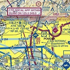
|
 Download PDF
of official airport diagram from the FAA
| Airport distance calculator |
|---|
|
|
| Sunrise and sunset |
|---|
|
Times for 06-Dec-2025
| | Local
(UTC-8) | | Zulu
(UTC) |
|---|
| Morning civil twilight | | 06:16 | | 14:16 |
| Sunrise | | 06:44 | | 14:44 |
| Sunset | | 16:41 | | 00:41 |
| Evening civil twilight | | 17:08 | | 01:08 |
|
| Current date and time |
|---|
| Zulu (UTC) | 06-Dec-2025 14:49:46 |
|---|
| Local (UTC-8) | 06-Dec-2025 06:49:46 |
|---|
|
| METAR |
|---|
| KPOC | 060447Z 00000KT 10SM CLR 11/01 A3007 RMK LAST
|
KCCB
5nm E | 119.525 909-985-4731
022200Z AUTO 26010KT 10SM CLR 19/M05 A2997 RMK AO2
|
KONT
10nm E | 061353Z VRB03KT 10SM CLR 08/01 A3006 RMK AO2 SLP176 T00830011 $
|
KCNO
10nm SE | 061353Z AUTO 00000KT 10SM CLR 05/02 A3007 RMK AO2 SLP184 T00500022
|
KEMT
12nm W | 060247Z 00000KT 10SM CLR 15/03 A3006
|
KAJO
15nm SE | 061356Z AUTO 10SM CLR 03/02 A3008 RMK AO2 SLP183 T00280017 $
|
KFUL
17nm SW | 061353Z AUTO 08003KT 10SM CLR 08/03 A3004 RMK AO2 SLP173 T00830028
|
KRAL
19nm SE | 061353Z AUTO 08004KT 10SM CLR 07/01 A3006 RMK AO2 SLP170 T00720006 $
|
|
| TAF |
|---|
KONT
10nm E | 061140Z 0612/0718 VRB05KT P6SM SKC
|
|
| NOTAMs |
|---|
NOTAMs are issued by the DoD/FAA and will open in a separate window not controlled by AirNav.
|
|


