FAA INFORMATION EFFECTIVE 14 MAY 2026
Location
| FAA Identifier: | VQQ |
| Lat/Long: | 30-13-07.6000N 081-52-37.8000W
30-13.126667N 081-52.630000W
30.2187778,-81.8771667
(estimated) |
| Elevation: | 79.5 ft. / 24.2 m (surveyed) |
| Variation: | 05W (2000) |
| Time zone: | UTC -4 (UTC -5 during Standard Time) |
| Zip code: | 32215 |
Airport Operations
| Airport use: | Open to the public |
| Control tower: | yes |
| ARTCC: | JACKSONVILLE CENTER |
| FSS: | SAINT PETERSBURG FLIGHT SERVICE STATION |
| NOTAMs facility: | VQQ (NOTAM-D service available) |
| Attendance: | SAT-SUN 0700-2100, ALL MON-FRI 0700-2300 |
| Wind indicator: | lighted |
| Segmented circle: | no |
| Lights: | WHEN ATCT CLSD ACTVT MALSR RWY 9R & 36R; REIL RWY 18L & 27L; HIRL RWY 18L/36R, 09R/27L - CTAF. |
| Beacon: | white-green (lighted land airport)
Operates sunset to sunrise. |
Airport Communications
| CTAF: | 126.1 |
| ATIS: | 125.275 |
| WX AWOS-3: | 125.275 (904-778-6934) |
| CECIL GROUND: | 121.625 226.675 [0700-2300 MON-FRI, 0700-2100 SAT-SUN.] |
| CECIL TOWER: | 126.1 235.625 [0700-2300 MON-FRI, 0700-2100 SAT-SUN.] |
| JACKSONVILLE APPROACH: | 127.775 |
| JACKSONVILLE DEPARTURE: | 127.775 |
| CLEARANCE DELIVERY: | 123.975 254.25 |
| ALCRN STAR: | 127.0 |
| WX AWOS-3 at HEG (5 nm NE): | 119.275 (904-741-2224) |
| WX AWOS-3 at NIP (10 nm E): | 119.275 |
| WX ASOS at JAX (19 nm NE): | 125.85 (904-549-9655) |
Nearby radio navigation aids
| VOR radial/distance | | VOR name | | Freq | | Var |
|---|
| CRGr252/20.3 | | CRAIG VORTAC | | 114.50 | | 03W |
| SGJr305/32.5 | | ST AUGUSTINE VOR/DME | | 109.40 | | 06W |
| GNVr037/37.7 | | GATORS VORTAC | | 116.55 | | 04W |
| NDB name | | Hdg/Dist | | Freq | | Var | | ID |
|---|
| REYNOLDS | | 330/18.9 | | 338 | | 07W | | RYD | .-. -.-- -.. |
Airport Services
| Fuel available: | 100LL JET-A1+ |
| Parking: | tiedowns |
| Airframe service: | MAJOR |
| Powerplant service: | MAJOR |
| Bottled oxygen: | HIGH/LOW |
| Bulk oxygen: | HIGH |
Runway Information
Runway 18L/36R
| Dimensions: | 12504 x 200 ft. / 3811 x 61 m |
| Surface: | asphalt/concrete, in good condition |
| Weight bearing capacity: | |
| Runway edge lights: | high intensity |
| RUNWAY 18L | | RUNWAY 36R |
| Latitude: | 30-14.101023N | | 30-12.038353N |
| Longitude: | 081-52.446308W | | 081-52.428118W |
| Elevation: | 79.0 ft. | | 71.6 ft. |
| Traffic pattern: | left | | left |
| Runway heading: | 185 magnetic, 180 true | | 005 magnetic, 360 true |
| Markings: | precision, in good condition | | precision, in good condition |
| Visual slope indicator: | 4-light PAPI on left (3.00 degrees glide path) | | 4-light PAPI on left (3.00 degrees glide path) |
| Approach lights: | | | MALSR: 1,400 foot medium intensity approach lighting system with runway alignment indicator lights |
| Runway end identifier lights: | yes | | no |
| Touchdown point: | yes, no lights | | yes, no lights |
| Instrument approach: | | | ILS/DME |
| Obstructions: | 74 ft. trees, 3125 ft. from runway, 320 ft. left of centerline, 40:1 slope to clear | | 87 ft. trees, 4595 ft. from runway, 500 ft. left of centerline |
Runway 9R/27L
| Dimensions: | 8003 x 200 ft. / 2439 x 61 m |
| Surface: | asphalt/concrete, in fair condition |
| Weight bearing capacity: | |
| Runway edge lights: | high intensity |
| RUNWAY 9R | | RUNWAY 27L |
| Latitude: | 30-12.938830N | | 30-12.948965N |
| Longitude: | 081-53.500100W | | 081-51.979898W |
| Elevation: | 76.5 ft. | | 63.8 ft. |
| Traffic pattern: | left | | left |
| Runway heading: | 095 magnetic, 090 true | | 275 magnetic, 270 true |
| Markings: | precision, in good condition | | nonprecision, in good condition |
| Visual slope indicator: | 4-light PAPI on left (3.00 degrees glide path) | | 4-light PAPI on left (3.00 degrees glide path) |
| Approach lights: | MALSR: 1,400 foot medium intensity approach lighting system with runway alignment indicator lights | | |
| Runway end identifier lights: | no | | yes |
| Touchdown point: | yes, no lights | | yes, no lights |
| Obstructions: | 76 ft. trees, 2860 ft. from runway, 225 ft. left of centerline, 35:1 slope to clear | | 50 ft. trees, 1920 ft. from runway, 550 ft. left of centerline, 34:1 slope to clear |
Runway 18R/36L
| Dimensions: | 8001 x 200 ft. / 2439 x 61 m |
| Surface: | asphalt/concrete, in poor condition
LONGL & TRANSVERSE CRACKING BTN INTS. |
| Weight bearing capacity: | |
| RUNWAY 18R | | RUNWAY 36L |
| Latitude: | 30-14.099973N | | 30-12.780063N |
| Longitude: | 081-52.579360W | | 081-52.567633W |
| Elevation: | 79.2 ft. | | 70.1 ft. |
| Traffic pattern: | left | | left |
| Runway heading: | 184 magnetic, 179 true | | 004 magnetic, 359 true |
| Markings: | precision, in fair condition | | nonprecision, in fair condition |
| Touchdown point: | yes, no lights | | yes, no lights |
| Obstructions: | 79 ft. trees, 3840 ft. from runway, 225 ft. right of centerline, 46:1 slope to clear | | none |
Runway 9L/27R
| Dimensions: | 4439 x 200 ft. / 1353 x 61 m |
| Surface: | asphalt/concrete, in good condition |
| Weight bearing capacity: | |
| Operational restrictions: | RSTD TO FIXED WING 12500 LBS & BLW. |
| RUNWAY 9L | | RUNWAY 27R |
| Latitude: | 30-13.054332N | | 30-13.059952N |
| Longitude: | 081-53.501145W | | 081-52.658017W |
| Elevation: | 79.5 ft. | | 71.3 ft. |
| Traffic pattern: | left | | left |
| Runway heading: | 095 magnetic, 090 true | | 275 magnetic, 270 true |
| Markings: | basic, in fair condition | | basic, in fair condition |
| Touchdown point: | yes, no lights | | yes, no lights |
| Obstructions: | 74 ft. trees, 2720 ft. from runway, 275 ft. left of centerline, 34:1 slope to clear | | none |
Helipad H1
| Dimensions: | 70 x 70 ft. / 21 x 21 m |
| Surface: | concrete, in good condition |
| Latitude: | 30-13.116615N | | |
| Longitude: | 081-53.487472W | | |
| Elevation: | 77.5 ft. | | |
| Traffic pattern: | left | | left |
| Markings: | basic, in good condition | | |
Helipad H2
| Dimensions: | 70 x 70 ft. / 21 x 21 m |
| Surface: | concrete, in good condition |
| Latitude: | 30-13.111610N | | |
| Longitude: | 081-53.130508W | | |
| Elevation: | 73.7 ft. | | |
| Traffic pattern: | left | | left |
| Markings: | basic, in good condition | | |
Airport Ownership and Management from official FAA records
| Ownership: | Publicly-owned |
| Owner: | JACKSONVILLE AVIATION AUTHORITY
14201 PECAN PARK ROAD
JACKSONVILLE, FL 32218-0018
Phone 904-741-2013 |
| Manager: | MATT BOCCHINO
13365 SIMPSON WAY
JACKSONVILLE, FL 32221-5522
Phone 904-573-1601 |
Additional Remarks
| - | CTN: DALGT GLDR OPS 6000 FT & BLW; HERLONG RECREATIONAL 5 NM NE. |
| - | ARNG: RAMP ACES PPR - D860-7728 OPTION 5; 1300-2130Z++ MON-FRI EXC HOL. |
| - | WILDLIFE INVOF ARPT. |
| - | HOLD SHRT SIGN RWY 9L/27R & 18R/36L UNLGTD. |
| - | 180 DEG TURN ON ASPH PTNS OF RWY BY P-3 OR LRGR NA. |
| - | MIL CARRIER BREAK NA. |
| - | ARNG: MIL ASSETS PPR - C904-573-2300 EXT 1012/1013/1014; TSNT CTC ARNG OPS - 40.90, 148.825 OR 248.2 BFR ENTRY TO PRK RAMP. |
| - | DEP TURNS PRIOR TO DER WO TWR APVL NA. |
| - | GCO AVBL ON FREQ 135.075 - JACKSONVILLE APCH. |
| - | FOR CD WHEN ATCT CLSD, AND UNA VIA GCO, CTC JACKSONVILLE TRACON AT 904-741-0284. |
| - | VTOL OPNS NOT AUTH. |
| - | RWY 18R/36L RSTD TO ACFT WITH WINGSPAN OF LESS THAN 79 FT, EXCLUDING TXY XG. |
| - | AIR TO FBO COMMUNICATIONS (MILLION AIR) AVBL ON 130.925. |
| - | 24 HR PPR FOR ACFT EQUIPPED WITH WEATHER MODIFICATION OR GEOENGINEERING EQPT 904-741-2020 |
| - | MISC: BOEING AEROSPACE SUPPORT CENTER AIR OPS MON-FRI 0700-1800, SAT PPR, CLSD SUN; ALL ARR - 904-317-2438/2425; 15 MIN PRIOR TO LNDG - 123.475 OR 264.65. |
| - | TWY C CLSD AT MIL GATE. TWY M CLSD EXC TO MIL ACFT. |
Instrument Procedures
NOTE: All procedures below are presented as PDF files. If you need a reader for these files, you should download the free Adobe Reader.NOT FOR NAVIGATION. Please procure official charts for flight.
FAA instrument procedures published for use from 14 May 2026 at 0901Z to 11 June 2026 at 0900Z.
STARs - Standard Terminal Arrivals |
|---|
| ALCRN ONE (RNAV) | |
download (155KB) |
| HOTAR ONE (RNAV) | |
download (227KB) |
| POGIE TWO | |
download (170KB) |
| QUBEN TWO (RNAV) | |
download (164KB) |
IAPs - Instrument Approach Procedures |
|---|
| ILS OR LOC RWY 36R **CHANGED** | |
download (364KB) |
| RNAV (GPS) RWY 09R **CHANGED** | |
download (299KB) |
| RNAV (GPS) RWY 18L **CHANGED** | |
download (326KB) |
| RNAV (GPS) RWY 27L **CHANGED** | |
download (281KB) |
| RNAV (GPS) RWY 36R **CHANGED** | |
download (290KB) |
| VOR RWY 27L **CHANGED** | |
download (262KB) |
| TACAN RWY 27L **CHANGED** | |
download (253KB) |
| NOTE: Special Alternate Minimums apply | |
download (129KB) |
| NOTE: Special Take-Off Minimums/Departure Procedures apply | |
download (162KB) |
Other nearby airports with instrument procedures:
KHEG - Herlong Recreational Airport (5 nm NE)
KNIP - Jacksonville Naval Air Station (Towers Field) (10 nm E)
KJAX - Jacksonville International Airport (19 nm NE)
KCRG - Jacksonville Executive Airport at Craig (20 nm E)
42J - Keystone Heights Airport (24 nm S)
|
|

Road maps at:
MapQuest
Bing
Google
| Aerial photo |
|---|
WARNING: Photo may not be current or correct
 Photo courtesy of Jacksonville Aviation Authority
Taken in May 2012
looking south.
Photo courtesy of Jacksonville Aviation Authority
Taken in May 2012
looking south.
Do you have a better or more recent aerial photo of Cecil Airport that you would like to share? If so, please send us your photo.
|
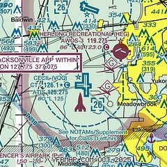
| Sectional chart |
|---|
|
 Download PDF
of official airport diagram from the FAA
| Airport distance calculator |
|---|
|
|
| Sunrise and sunset |
|---|
|
Times for 21-May-2026
| | Local
(UTC-4) | | Zulu
(UTC) |
|---|
| Morning civil twilight | | 06:05 | | 10:05 |
| Sunrise | | 06:31 | | 10:31 |
| Sunset | | 20:17 | | 00:17 |
| Evening civil twilight | | 20:43 | | 00:43 |
|
| Current date and time |
|---|
| Zulu (UTC) | 21-May-2026 05:06:28 |
|---|
| Local (UTC-4) | 21-May-2026 01:06:28 |
|---|
|
| METAR |
|---|
| KVQQ | 210455Z AUTO 00000KT 10SM CLR 21/20 A3008 RMK AO2
|
KHEG
5nm NE | 210455Z AUTO 00000KT 10SM CLR 22/21 A3010 RMK AO2 TSNO
|
KNEN
8nm N | 210453Z AUTO 00000KT 10SM CLR 21/19 A3009 RMK AO2 SLP251 T02060194 403170161 $
|
KNIP
11nm E | 210453Z AUTO 16008KT 10SM CLR 24/21 A3008 RMK AO2 SLP182 T02440211 403000222
|
KJAX
20nm NE | 210456Z 17005KT 10SM CLR 23/20 A3007 RMK AO2 SLP182 T02280200 403110183 $
|
KCRG
20nm E | 210453Z AUTO 17004KT 10SM CLR 23/20 A3008 RMK AO2 SLP184 T02280200 403000189
|
|
| TAF |
|---|
| KVQQ | 201727Z 2018/2118 12010KT P6SM SCT045 BKN250 FM210100 13006KT P6SM SCT030 FM210600 VRB02KT 3SM BR SCT250 TEMPO 2106/2109 1SM BR FM211500 15006KT P6SM SCT040
|
KNIP
11nm E | 202300Z 2023/2123 11012KT 9999 SCT030 SCT250 QNH3001INS FM210400 15007KT 9999 SCT025 QNH3002INS FM210700 17003KT 9999 FEW015 QNH3001INS FM211500 19007KT 9999 SCT030 SCT250 QNH2998INS FM211800 12009KT 9999 BKN035 BKN250 QNH2997INS AUTOMATED SENSOR METWATCH 2103 TIL 2109 TX32/2119Z TN23/2110Z COR 2322 FN20115
|
KJAX
20nm NE | 201948Z 2020/2118 08010G17KT P6SM SCT040 FM210100 13006KT P6SM SCT030 FM210600 VRB02KT P6SM FEW250 FM211500 16006KT P6SM SCT035
|
KCRG
20nm E | 201727Z 2018/2118 10010G17KT P6SM FEW040 SCT250 FM210100 14006KT P6SM SCT030 FM210600 VRB02KT P6SM FEW250 FM211500 16006KT P6SM SCT035
|
|
| NOTAMs |
|---|
NOTAMs are issued by the DoD/FAA and will open in a separate window not controlled by AirNav.
|
|


