FAA INFORMATION EFFECTIVE 19 FEBRUARY 2026
Location
| FAA Identifier: | 02G |
| Lat/Long: | 40-40-23.9000N 080-38-29.1000W
40-40.398333N 080-38.485000W
40.6733056,-80.6414167
(estimated) |
| Elevation: | 1160.5 ft. / 353.7 m (surveyed) |
| Variation: | 08W (2000) |
| From city: | 4 miles NW of EAST LIVERPOOL, OH |
| Time zone: | UTC -5 (UTC -4 during Daylight Saving Time) |
| Zip code: | 43920 |
Airport Operations
| Airport use: | Open to the public |
| Activation date: | 01/1938 |
| Control tower: | no |
| ARTCC: | CLEVELAND CENTER |
| FSS: | CLEVELAND FLIGHT SERVICE STATION |
| NOTAMs facility: | CLE (NOTAM-D service available) |
| Attendance: | UNATNDD |
| Wind indicator: | lighted |
| Segmented circle: | no |
| Lights: | ACTVT REIL RWY 07 & 25; PAPI RWY 25; MIRL RWY 07/25 - CTAF. |
| Beacon: | white-green (lighted land airport)
Operates sunset to sunrise. |
Airport Communications
| CTAF/UNICOM: | 123.0 |
| PITTSBURGH APPROACH: | 124.75 |
| PITTSBURGH DEPARTURE: | 124.75 |
| CLASS B: | 124.75 |
| WX AWOS-3PT at BVI (13 nm NE): | 118.35 (724-843-1024) |
| WX AWOS-3 at 2G2 (19 nm S): | 121.625 (740-275-4862) |
Nearby radio navigation aids
| VOR radial/distance | | VOR name | | Freq | | Var |
|---|
| EWCr253/21.6 | | ELLWOOD CITY VOR/DME | | 115.80 | | 08W |
| HLGr359/25.0 | | WHEELING VOR/DME | | 114.25 | | 07W |
| BSVr100/36.2 | | BRIGGS VOR/DME | | 114.05 | | 04W |
| AGCr320/36.2 | | ALLEGHENY VOR/DME | | 110.00 | | 09W |
| ACOr140/36.4 | | AKRON VOR/DME | | 114.40 | | 04W |
| NDB name | | Hdg/Dist | | Freq | | Var | | ID |
|---|
| CASTLE | | 215/23.3 | | 272 | | 09W | | UCP | ..- -.-. .--. |
| CADIZ | | 040/31.2 | | 239 | | 07W | | CFX | -.-. ..-. -..- |
Airport Services
| Fuel available: | 100LL
100LL:100LL AVBL H24 SELF SVC VIA CREDIT CARD. |
| Parking: | tiedowns |
| Airframe service: | NONE |
| Powerplant service: | NONE |
| Bottled oxygen: | NONE |
| Bulk oxygen: | NONE |
Runway Information
Runway 7/25
| Dimensions: | 3503 x 75 ft. / 1068 x 23 m |
| Surface: | asphalt, in good condition |
| Weight bearing capacity: | |
| Runway edge lights: | medium intensity |
| RUNWAY 7 | | RUNWAY 25 |
| Latitude: | 40-40.257615N | | 40-40.540542N |
| Longitude: | 080-38.815717W | | 080-38.155467W |
| Elevation: | 1142.7 ft. | | 1160.3 ft. |
| Traffic pattern: | left | | left |
| Runway heading: | 069 magnetic, 061 true | | 249 magnetic, 241 true |
| Markings: | nonprecision, in good condition | | nonprecision, in good condition |
| Visual slope indicator: | | | 4-light PAPI on left (3.00 degrees glide path) |
| Runway end identifier lights: | yes | | yes |
| Touchdown point: | yes, no lights | | yes, no lights |
| Obstructions: | 8 ft. tree, 321 ft. from runway, 58 ft. right of centerline, 15:1 slope to clear | | 60 ft. trees, 1325 ft. from runway, 105 ft. left of centerline, 18:1 slope to clear |
Airport Ownership and Management from official FAA records
| Ownership: | Publicly-owned |
| Owner: | COLUMBIANA CO ARPT AUTH
PO BOX 81
EAST LIVERPOOL, OH 43920-5081
Phone 330-397-5769 |
| Manager: | JAMES PUSATERI
PO BOX 81
EAST LIVERPOOL, OH 43920-5081
Phone 330-397-5769 |
Additional Remarks
| - | LGTD OBSTN HI TENSION LINE 1.5 NM NW. |
| - | DEER, BIRDS, & OTR WILDLIFE ON & INVOF ARPT. |
| - | FOR CD CTC PITTSBURGH APCH AT 412-472-5591. |
Instrument Procedures
NOTE: All procedures below are presented as PDF files. If you need a reader for these files, you should download the free Adobe Reader.NOT FOR NAVIGATION. Please procure official charts for flight.
FAA instrument procedures published for use from 19 February 2026 at 0901Z to 19 March 2026 at 0900Z.
IAPs - Instrument Approach Procedures |
|---|
| RNAV (GPS) RWY 25 | |
download (200KB) |
| NOTE: Special Take-Off Minimums/Departure Procedures apply | |
download (603KB) |
Other nearby airports with instrument procedures:
KBVI - Beaver County Airport (13 nm NE)
4G4 - Youngstown Elser Metro Airport (17 nm N)
2G2 - Geary A Bates/Jefferson County Airpark (19 nm S)
38D - Salem Airpark (19 nm NW)
KTSO - Carroll County/Tolson Airport (21 nm W)
|
|

Road maps at:
MapQuest
Bing
Google
| Aerial photo |
|---|
WARNING: Photo may not be current or correct

Do you have a better or more recent aerial photo of Columbiana County Airport that you would like to share? If so, please send us your photo.
|
| Sectional chart |
|---|
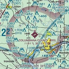
|
| Airport distance calculator |
|---|
|
|
| Sunrise and sunset |
|---|
|
Times for 14-Mar-2026
| | Local
(UTC-4) | | Zulu
(UTC) |
|---|
| Morning civil twilight | | 07:10 | | 11:10 |
| Sunrise | | 07:37 | | 11:37 |
| Sunset | | 19:27 | | 23:27 |
| Evening civil twilight | | 19:54 | | 23:54 |
|
| Current date and time |
|---|
| Zulu (UTC) | 14-Mar-2026 17:02:30 |
|---|
| Local (UTC-4) | 14-Mar-2026 13:02:30 |
|---|
|
| METAR |
|---|
KBVI
12nm NE | 132147Z 27029G41KT 10SM SCT060 OVC085 15/M09 A2953
|
KPIT
20nm SE | 141651Z 25006KT 10SM FEW035 SCT150 SCT250 04/M09 A3019 RMK AO2 SLP240 T00391089
|
KUCP
24nm NE | 141656Z AUTO 24009KT 10SM FEW043 04/M08 A3020 RMK AO2 SLP251 T00441083
|
|
| TAF |
|---|
KBVI
12nm NE | 141120Z 1412/1512 28010G20KT P6SM SCT035 FM141900 29008KT P6SM BKN200 FM150000 VRB03KT P6SM BKN100
|
KPIT
20nm SE | 141449Z 1415/1518 29009KT P6SM FEW035 BKN200 FM150000 VRB03KT P6SM BKN100 FM150900 11008KT P6SM BKN070 WS020/17040KT FM151400 15012G22KT P6SM BKN200
|
|
| NOTAMs |
|---|
NOTAMs are issued by the DoD/FAA and will open in a separate window not controlled by AirNav.
|
|


