FAA INFORMATION EFFECTIVE 09 JULY 2026
Location
| FAA Identifier: | 4G4 |
| Lat/Long: | 40-57-42.4630N 080-40-38.3750W
40-57.707717N 080-40.639583W
40.9617953,-80.6773264
(estimated) |
| Elevation: | 1069.6 ft. / 326.0 m (surveyed) |
| Variation: | 08W (2000) |
| From city: | 8 miles S of YOUNGSTOWN, OH |
| Time zone: | UTC -4 (UTC -5 during Standard Time) |
| Zip code: | 44452 |
Airport Operations
| Airport use: | Open to the public |
| Activation date: | 01/1947 |
| Control tower: | no |
| ARTCC: | CLEVELAND CENTER |
| FSS: | CLEVELAND FLIGHT SERVICE STATION |
| NOTAMs facility: | CLE (NOTAM-D service available) |
| Attendance: | 0730-1800
UNATNDD EASTER, THANKSGIVING, & CHRISTMAS. |
| Wind indicator: | yes |
| Segmented circle: | no |
| Lights: | SS-SR |
| Beacon: | white-green (lighted land airport)
Operates sunset to sunrise. |
Airport Communications
| CTAF/UNICOM: | 123.05 |
| YOUNGSTOWN APPROACH: | 133.95 |
| YOUNGSTOWN DEPARTURE: | 133.95 |
| CLEARANCE DELIVERY: | 119.25 |
| WX AWOS-3PT at UCP (13 nm E): | 124.175 ((724) 652-4184) |
| WX AWOS-3PT at BVI (17 nm SE): | 118.35 (724-843-1024) |
| WX ASOS at YNG (18 nm N): | PHONE 330-967-8953 |
- APCH/DEP SVC PRVDD BY CLEVELAND ARTCC (ZOB) ON FREQS 120.6/379.275 (MOUNT HOPE RCAG) WHEN YOUNGSTOWN APCH CTL CLSD.
Nearby radio navigation aids
| VOR radial/distance | | VOR name | | Freq | | Var |
|---|
| EWCr299/22.7 | | ELLWOOD CITY VOR/DME | | 115.80 | | 08W |
| ACOr114/25.3 | | AKRON VOR/DME | | 114.40 | | 04W |
| BSVr073/36.7 | | BRIGGS VOR/DME | | 114.05 | | 04W |
| NDB name | | Hdg/Dist | | Freq | | Var | | ID |
|---|
| CASTLE | | 262/12.4 | | 272 | | 09W | | UCP | ..- -.-. .--. |
| FETCH | | 202/14.8 | | 338 | | 08W | | YN | -.-- -. |
Airport Services
| Fuel available: | 100LL JET-A+ |
| Parking: | hangars |
| Airframe service: | MAJOR |
| Powerplant service: | MAJOR |
| Bottled oxygen: | NONE |
| Bulk oxygen: | HIGH/LOW |
Runway Information
Runway 10/28
| Dimensions: | 4012 x 50 ft. / 1223 x 15 m |
| Surface: | asphalt, in fair condition
LRG TRANSVERSE CTL CRACKS SPACED DOWN RWY. |
| Runway edge lights: | medium intensity |
| RUNWAY 10 | | RUNWAY 28 |
| Latitude: | 40-57.703483N | | 40-57.698350N |
| Longitude: | 080-41.076533W | | 080-40.205000W |
| Elevation: | 1012.0 ft. | | 1069.6 ft. |
| Traffic pattern: | left | | left |
| Runway heading: | 098 magnetic, 090 true | | 278 magnetic, 270 true |
| Displaced threshold: | 348 ft. | | 259 ft. |
| Markings: | nonprecision, in good condition | | nonprecision, in good condition |
| Visual slope indicator: | 2-light PAPI on left | | 2-light PAPI on left (3.75 degrees glide path) |
| Runway end identifier lights: | yes | | yes |
| Touchdown point: | yes, no lights | | yes, no lights |
| Obstructions: | 85 ft. trees, 201 ft. from runway, 235 ft. left of centerline
40-80 FT TREES, 200 FT DIST, 135 FT L/R. | | 85 ft. trees, 280 ft. from runway, 240 ft. left of centerline
30 FT FONE POLES, 200 FT DIST, 140 FT L & 190 FT R; 18 FT ROAD, 160 FT DIST, 250 FT L/R; 6 FT FENCE, 140 FT DIST, 100 FT L/R; 25 FT HNGRS, 45-100 FT DIST, 207 FT L. |
Airport Ownership and Management from official FAA records
| Ownership: | Privately-owned |
| Owner: | MICHAEL E STANKO
8491 IVY HILL DR
POLAND, OH 44514-5214
Phone 330-757-1147 |
| Manager: | MICHAEL E STANKO
10800 SHARROTT RD
NORTH LIMA, OH 44452-9523
Phone 330-549-0337 |
Additional Remarks
| A30A-10 | CALM WIND RWY. |
| - | TWR 1085'AGL /2118'MSL/ LCTD 7-1/2 NM NNE. |
| - | FOR CD CTC YOUNGSTOWN APCH AT 330-856-4806, WHEN APCH CLSD CTC CLEVELAND ARTCC AT 440-774-0223/0490. |
Instrument Procedures
NOTE: All procedures below are presented as PDF files. If you need a reader for these files, you should download the free Adobe Reader.NOT FOR NAVIGATION. Please procure official charts for flight.
FAA instrument procedures published for use from 09 July 2026 at 0901Z to 06 August 2026 at 0900Z.
IAPs - Instrument Approach Procedures |
|---|
| RNAV (GPS) RWY 10 | |
download (207KB) |
| RNAV (GPS) RWY 28 | |
download (209KB) |
| NOTE: Special Take-Off Minimums/Departure Procedures apply | |
download (230KB) |
Other nearby airports with instrument procedures:
38D - Salem Airpark (8 nm W)
KUCP - New Castle Municipal Airport (13 nm E)
3G6 - Tri-City Airport (15 nm W)
KBVI - Beaver County Airport (17 nm SE)
02G - Columbiana County Airport (17 nm S)
KYNG - Youngstown/Warren Regional Airport (18 nm N)
|
|

Road maps at:
MapQuest
Bing
Google
| Aerial photo |
|---|
WARNING: Photo may not be current or correct

Do you have a better or more recent aerial photo of Youngstown Elser Metro Airport that you would like to share? If so, please send us your photo.
|
| Sectional chart |
|---|
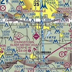
|
| Airport distance calculator |
|---|
|
|
| Sunrise and sunset |
|---|
|
Times for 18-Jul-2026
| | Local
(UTC-4) | | Zulu
(UTC) |
|---|
| Morning civil twilight | | 05:35 | | 09:35 |
| Sunrise | | 06:07 | | 10:07 |
| Sunset | | 20:51 | | 00:51 |
| Evening civil twilight | | 21:23 | | 01:23 |
|
| Current date and time |
|---|
| Zulu (UTC) | 19-Jul-2026 03:24:40 |
|---|
| Local (UTC-4) | 18-Jul-2026 23:24:40 |
|---|
|
| METAR |
|---|
KUCP
13nm E | 190256Z AUTO 28003KT 10SM -RA SCT016 BKN022 OVC036 22/22 A2986 RMK AO2 RAE20B52 SLP119 P0000 60001 T02170217 53013
|
KBVI
17nm SE | 190255Z AUTO 32003KT 10SM -DZ SCT004 BKN031 OVC044 22/21 A2987 RMK AO2 T02230208
|
KYNG
17nm N | 190251Z 33009KT 4SM BR FEW020 BKN036 OVC070 22/20 A2987 RMK AO2 RAE01 SLP103 P0001 60001 T02170200 53019 $
|
|
| TAF |
|---|
KBVI
17nm SE | 190131Z 1902/1924 24010G20KT 1SM -TSRA BR OVC010CB FM190215 32005KT P6SM BKN050 FM190800 32006KT P6SM BKN015 FM191200 32008KT P6SM BKN025 FM191600 32008KT P6SM SCT035
|
KYNG
17nm N | 190145Z 1902/1924 29005KT P6SM SCT015 BKN028 FM190300 33005KT 6SM HZ SCT035 FM190600 34005KT 6SM HZ SCT015 BKN025 FM191600 34007KT P6SM SCT250
|
|
| NOTAMs |
|---|
NOTAMs are issued by the DoD/FAA and will open in a separate window not controlled by AirNav.
|
|


