FAA INFORMATION EFFECTIVE 27 NOVEMBER 2025
Location
| FAA Identifier: | 3G6 |
| Lat/Long: | 40-54-21.6000N 081-00-00.1000W
40-54.360000N 081-00.001667W
40.9060000,-81.0000278
(estimated) |
| Elevation: | 1187.5 ft. / 362.0 m (surveyed) |
| Variation: | 09W (2025) |
| From city: | 1 mile SE of SEBRING, OH |
| Time zone: | UTC -5 (UTC -4 during Daylight Saving Time) |
| Zip code: | 44609 |
Airport Operations
| Airport use: | Open to the public |
| Activation date: | 07/1969 |
| Control tower: | no |
| ARTCC: | CLEVELAND CENTER |
| FSS: | CLEVELAND FLIGHT SERVICE STATION |
| NOTAMs facility: | CLE (NOTAM-D service available) |
| Attendance: | UNATNDD |
| Wind indicator: | yes |
| Segmented circle: | no |
| Lights: | ACTVT NSTD LIRL RWY 18/36 - CTAF. |
Airport Communications
| CTAF: | 122.9 |
| CLEVELAND APPROACH: | 125.5 |
| CLEVELAND DEPARTURE: | 125.5 |
- APCH/DEP SVC PRVDD BY CLEVELAND APCH (CLE) 0600-0100. APCH/DEP SVC PRVDD BY CLEVELAND ARTCC (ZOB) ON FREQS 120.6/379.275 (MOUNT HOPE RCAG) 0100-0600.
Nearby radio navigation aids
| VOR radial/distance | | VOR name | | Freq | | Var |
|---|
| ACOr147/15.2 | | AKRON VOR/DME | | 114.40 | | 04W |
| BSVr067/22.0 | | BRIGGS VOR/DME | | 114.05 | | 04W |
| EWCr286/36.1 | | ELLWOOD CITY VOR/DME | | 115.80 | | 08W |
| CXRr174/37.4 | | CHARDON VOR/DME | | 112.70 | | 05W |
| NDB name | | Hdg/Dist | | Freq | | Var | | ID |
|---|
| CASTLE | | 264/27.4 | | 272 | | 09W | | UCP | ..- -.-. .--. |
Airport Services
| Fuel available: | 100LL
100LL:AVBL ON REQ CALL AMGR. |
| Parking: | tiedowns |
| Airframe service: | NONE |
| Powerplant service: | NONE |
| Bottled oxygen: | NONE |
| Bulk oxygen: | NONE |
Runway Information
Runway 18/36
| Dimensions: | 2768 x 45 ft. / 844 x 14 m |
| Surface: | asphalt, in poor condition
EXCESSIVE CRACKING, VEGETATION THRU CRACKS & JOINTS, & UNEVEN ROUGH PAVEMENT. |
| Runway edge lights: | non-standard
NSTD LIRL DUE TO LAYOUT, COLORS, & NON-FRANGIBLE FIXTURES. |
| Runway edge markings: | CNTRLN FADED.
NSTD BASIC DUE TO NRS LAYOUT & SIZE. |
| RUNWAY 18 | | RUNWAY 36 |
| Latitude: | 40-54.585583N | | 40-54.134550N |
| Longitude: | 081-00.044550W | | 080-59.957617W |
| Elevation: | 1184.7 ft. | | 1177.9 ft. |
| Traffic pattern: | left | | left |
| Runway heading: | 181 magnetic, 172 true | | 001 magnetic, 352 true |
| Markings: | NSTD, in fair condition | | NSTD, in fair condition |
| Touchdown point: | yes, no lights | | yes, no lights |
| Obstructions: | none
+18 FT TREES, 46 FT DIST, 92 FT R; +5 FT TREES, 119 FT DIST, 34 FT R. | | 18 ft. pole, 315 ft. from runway, 130 ft. both sides of centerline, 6:1 slope to clear
+45 FT TREE, 188 FT DIST, 108 FT R. |
Airport Ownership and Management from official FAA records
| Ownership: | Privately-owned |
| Owner: | 3G6 LLC
18330 STATE ROUTE 62
BELOIT, OH 44609-9520
Phone 330-938-1216 |
| Manager: | WAYNE HARTER JR
18330 STATE ROUTE 62
BELOIT, OH 44609-9520
Phone 330-428-1269 |
Additional Remarks
| - | FOR CD CTC CLEVELAND APCH AT 216-352-2323, WHEN APCH CLSD CTC CLEVELAND ARTCC AT 440-774-0223/0490. |
| - | DEER, BIRDS, & WILDLIFE ON & INVOF ARPT. |
Instrument Procedures
NOTE: All procedures below are presented as PDF files. If you need a reader for these files, you should download the free Adobe Reader.NOT FOR NAVIGATION. Please procure official charts for flight.
FAA instrument procedures published for use from 27 November 2025 at 0901Z to 25 December 2025 at 0900Z.
IAPs - Instrument Approach Procedures |
|---|
| RNAV (GPS) RWY 18 | |
download (165KB) |
| VOR RWY 18 | |
download (181KB) |
| NOTE: Special Take-Off Minimums/Departure Procedures apply | |
download (474KB) |
Other nearby airports with instrument procedures:
38D - Salem Airpark (7 nm E)
4G4 - Youngstown Elser Metro Airport (15 nm E)
KCAK - Akron-Canton Regional Airport (20 nm W)
KTSO - Carroll County/Tolson Airport (21 nm S)
02G - Columbiana County Airport (21 nm SE)
|
|

Road maps at:
MapQuest
Bing
Google
| Aerial photo |
|---|
WARNING: Photo may not be current or correct
 Photo taken 03-Jul-2005
from approx. 5000' AGL
Photo taken 03-Jul-2005
from approx. 5000' AGL
Do you have a better or more recent aerial photo of Tri-City Airport that you would like to share? If so, please send us your photo.
|
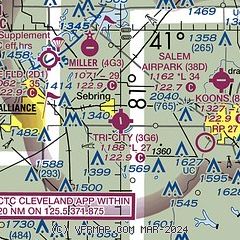
| Sectional chart |
|---|
|
| Airport distance calculator |
|---|
|
|
| Sunrise and sunset |
|---|
|
Times for 18-Dec-2025
| | Local
(UTC-5) | | Zulu
(UTC) |
|---|
| Morning civil twilight | | 07:13 | | 12:13 |
| Sunrise | | 07:44 | | 12:44 |
| Sunset | | 16:57 | | 21:57 |
| Evening civil twilight | | 17:28 | | 22:28 |
|
| Current date and time |
|---|
| Zulu (UTC) | 18-Dec-2025 18:32:16 |
|---|
| Local (UTC-5) | 18-Dec-2025 13:32:16 |
|---|
|
| METAR |
|---|
KCAK
20nm W | 181751Z 19018G29KT 10SM FEW032 SCT100 SCT250 13/02 A2981 RMK AO2 PK WND 19030/1720 SLP100 ACSL S-SW T01330017 10133 20028 58041 $
|
KPOV
22nm NW | 181815Z AUTO 19009G17KT 140V230 10SM CLR 13/M01 A2979 RMK AO2 T01321009
|
KAKR
22nm W | 181754Z AUTO 19018G27KT 10SM CLR 13/02 A2978 RMK AO2 PK WND 20027/1751 SLP089 T01330017 10133 20044 58041
|
KYNG
26nm NE | 181751Z 16011KT 10SM FEW120 SCT250 12/M02 A2983 RMK AO2 PK WND 16032/1706 SLP106 60000 T01171022 10117 20017 58039
|
KUCP
28nm E | 181756Z AUTO VRB06KT 10SM CLR 13/M01 A2986 RMK AO2 SLP133 T01281011 10128 21033 58042
|
KBVI
28nm E | 181815Z AUTO 20007G19KT 10SM SCT100 15/M03 A2987 RMK AO2 T01481034
|
KPHD
32nm SW | 181753Z AUTO 18011G21KT 10SM CLR 13/M01 A2985 RMK AO2 PK WND 18027/1721 SLP111 T01331006 10139 20011 58041
|
KPJC
39nm E | 181815Z AUTO 15011G18KT 10SM CLR 13/M01 A2988 RMK AO2
|
KBJJ
40nm W | 181756Z AUTO 19017G26KT 10SM CLR 11/03 A2978 RMK AO2 PK WND 19032/1745 SLP093 T01110033 10117 20033 58042
|
|
| TAF |
|---|
KCAK
20nm W | 181748Z 1818/1918 18015G25KT P6SM SCT040 OVC090 FM182300 20017G27KT P6SM -SHRA SCT025 BKN035 FM190300 20020G28KT 4SM -RA SCT008 OVC020 TEMPO 1904/1906 26022G36KT 1SM RA OVC008 FM190600 24015G25KT P6SM -SHRA SCT007 OVC010 FM191100 27020G32KT 5SM -RASN SCT007 OVC010 FM191300 27020G32KT P6SM -SHSN BKN025 PROB30 1914/1916 4SM -SHSN BKN025
|
|
| NOTAMs |
|---|
NOTAMs are issued by the DoD/FAA and will open in a separate window not controlled by AirNav.
|
|


