FAA INFORMATION EFFECTIVE 07 AUGUST 2025
Location
| FAA Identifier: | 1K4 |
| Lat/Long: | 35-09-18.2430N 097-28-13.4180W
35-09.304050N 097-28.223633W
35.1550675,-97.4703939
(estimated) |
| Elevation: | 1168.8 ft. / 356.3 m (surveyed) |
| Variation: | 03E (2025) |
| From city: | 1 mile NE of GOLDSBY, OK |
| Time zone: | UTC -5 (UTC -6 during Standard Time) |
| Zip code: | 73072 |
Airport Operations
| Airport use: | Open to the public |
| Activation date: | 01/1946 |
| Control tower: | no |
| ARTCC: | FORT WORTH CENTER |
| FSS: | MC ALESTER FLIGHT SERVICE STATION |
| NOTAMs facility: | MLC (NOTAM-D service available) |
| Attendance: | MON-FRI 0800-1700 |
| Wind indicator: | lighted |
| Segmented circle: | yes |
| Lights: | ACTVT MIRL RY 13/31 DUSK-DAWN - CTAF. |
| Beacon: | white-green (lighted land airport)
Operates sunset to sunrise. |
Airport Communications
| CTAF/UNICOM: | 122.7 |
| OKE CITY APPROACH: | 120.45 |
| OKE CITY DEPARTURE: | 120.45 |
| WX AWOS-3PT at OUN (5 nm N): | 119.55 (405-325-7302) |
| WX ASOS at OKC (16 nm NW): | PHONE 405-674-4013 |
Nearby radio navigation aids
| VOR radial/distance | | VOR name | | Freq | | Var |
|---|
| IRWr144/14.0 | | WILL ROGERS VORTAC | | 114.10 | | 07E |
| PWAr151/24.3 | | WILEY POST VOR/DME | | 113.40 | | 08E |
Airport Services
| Fuel available: | 100LL
100LL:24 HR AUTOMATED FUEL SERVICING SYSTEM. |
| Parking: | tiedowns |
| Airframe service: | NONE |
| Powerplant service: | NONE |
| Bottled oxygen: | NONE |
| Bulk oxygen: | NONE |
Runway Information
Runway 13/31
| Dimensions: | 3004 x 60 ft. / 916 x 18 m |
| Surface: | concrete/grooved, in good condition |
| Weight bearing capacity: | |
| Runway edge lights: | medium intensity |
| RUNWAY 13 | | RUNWAY 31 |
| Latitude: | 35-09.465678N | | 35-09.103805N |
| Longitude: | 097-28.421647W | | 097-28.010005W |
| Elevation: | 1167.0 ft. | | 1156.6 ft. |
| Traffic pattern: | left | | left |
| Runway heading: | 133 magnetic, 136 true | | 313 magnetic, 316 true |
| Markings: | basic, in good condition | | nonprecision, in good condition |
| Touchdown point: | yes, no lights | | yes, no lights |
| Obstructions: | 76 ft. trees, 1380 ft. from runway, 219 ft. right of centerline, 15:1 slope to clear | | 35 ft. trees, 1108 ft. from runway, 78 ft. right of centerline, 25:1 slope to clear |
Runway 18/36
| Dimensions: | 1801 x 60 ft. / 549 x 18 m |
| Surface: | asphalt, in good condition |
| Weight bearing capacity: | |
| RUNWAY 18 | | RUNWAY 36 |
| Latitude: | 35-09.483048N | | 35-09.186283N |
| Longitude: | 097-28.234607W | | 097-28.243185W |
| Elevation: | 1168.8 ft. | | 1160.8 ft. |
| Traffic pattern: | left | | left |
| Runway heading: | 178 magnetic, 181 true | | 358 magnetic, 001 true |
| Markings: | basic, in fair condition | | basic, in fair condition |
| Touchdown point: | yes, no lights | | yes, no lights |
| Obstructions: | 45 ft. trees, 806 ft. from runway, 28 ft. left of centerline, 13:1 slope to clear | | none |
Airport Ownership and Management from official FAA records
| Ownership: | Publicly-owned |
| Owner: | TOWN OF GOLDSBY
100 E. CENTER ROAD
GOLDSBY, OK 73093
Phone 405-288-6675 |
| Manager: | RONNY NELSON
351 DJP MEMORIAL BLVD., 100 E. CENTER ROAD
GOLDSBY, OK 73093
Phone 405-570-8399
PUBLIC WORKS DIRECTOR. |
Additional Remarks
| - | INTENSIVE STUDENT TRNG DALGT HRS. |
| - | ULTRALIGHT ACT ON & INVOF ARPT. |
| - | COYOTES ON & INVOF RWY. |
| - | FOR CD CTC OKE CITY APCH AT 405-681-5683. |
Instrument Procedures
NOTE: All procedures below are presented as PDF files. If you need a reader for these files, you should download the free Adobe Reader.NOT FOR NAVIGATION. Please procure official charts for flight.
FAA instrument procedures published for use from 07 August 2025 at 0901Z to 04 September 2025 at 0900z.
STARs - Standard Terminal Arrivals |
|---|
| GULLI THREE | |
2 pages:
[1] [2] (335KB) |
IAPs - Instrument Approach Procedures |
|---|
| RNAV (GPS) RWY 31 | |
download (225KB) |
| NOTE: Special Take-Off Minimums/Departure Procedures apply | |
download (388KB) |
Other nearby airports with instrument procedures:
KOUN - University of Oklahoma Westheimer Airport (5 nm N)
KHMY - Muldrow Army Heliport (14 nm SE)
KOKC - OKC Will Rogers International Airport (16 nm NW)
KTIK - Tinker Air Force Base (16 nm N)
KPWA - Wiley Post Airport (24 nm N)
|
|

Road maps at:
MapQuest
Bing
Google
| Aerial photo |
|---|
WARNING: Photo may not be current or correct
 Photo by Steve Ruse
Taken in October 2009
Photo by Steve Ruse
Taken in October 2009
Do you have a better or more recent aerial photo of David Jay Perry Airport that you would like to share? If so, please send us your photo.
|
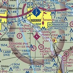
| Sectional chart |
|---|
|
| Airport distance calculator |
|---|
|
|
| Sunrise and sunset |
|---|
|
Times for 13-Aug-2025
| | Local
(UTC-5) | | Zulu
(UTC) |
|---|
| Morning civil twilight | | 06:22 | | 11:22 |
| Sunrise | | 06:49 | | 11:49 |
| Sunset | | 20:20 | | 01:20 |
| Evening civil twilight | | 20:47 | | 01:47 |
|
| Current date and time |
|---|
| Zulu (UTC) | 13-Aug-2025 05:07:50 |
|---|
| Local (UTC-5) | 13-Aug-2025 00:07:50 |
|---|
|
| METAR |
|---|
KOUN
4nm N | 130450Z AUTO 19004KT 10SM CLR 25/20 A3000 RMK AO2 T02480202
|
KOKC
15nm NW | 130452Z 17004KT 10SM FEW250 23/20 A3001 RMK AO2 SLP148 T02330200
|
KTIK
16nm N | 130455Z AUTO 17003KT 10SM CLR 24/21 A2996 RMK AO2 SLP133 T02430212
|
|
| TAF |
|---|
KOUN
4nm N | 121720Z 1218/1318 VRB05KT P6SM SCT050 SCT100 PROB30 1221/1302 3SM TSRA BKN030CB FM130200 VRB04KT P6SM SCT250
|
KOKC
15nm NW | 121720Z 1218/1318 VRB06KT P6SM SCT050 SCT100 PROB30 1221/1302 3SM TSRA BKN030CB FM130200 VRB04KT P6SM SCT250
|
KTIK
16nm N | 130100Z 1301/1407 19009KT 9999 FEW050 SCT250 QNH2990INS BECMG 1315/1316 10009KT 9999 SCT050 SCT250 QNH2987INS TX32/1321Z TN20/1312Z
|
|
| NOTAMs |
|---|
NOTAMs are issued by the DoD/FAA and will open in a separate window not controlled by AirNav.
|
|

