FAA INFORMATION EFFECTIVE 14 MAY 2026
Location
| FAA Identifier: | 3T7 |
| Lat/Long: | 41-41-18.2000N 082-48-29.4000W
41-41.303333N 082-48.490000W
41.6883889,-82.8081667
(estimated) |
| Elevation: | 579 ft. / 176 m (estimated) |
| Variation: | 07W (2000) |
| From city: | 1 mile NE of MIDDLE BASS ISLAND, OH |
| Time zone: | UTC -4 (UTC -5 during Standard Time) |
| Zip code: | 43456 |
Airport Operations
| Airport use: | Open to the public |
| Activation date: | 12/2002 |
| Control tower: | no |
| ARTCC: | CLEVELAND CENTER |
| FSS: | CLEVELAND FLIGHT SERVICE STATION |
| NOTAMs facility: | CLE (NOTAM-D service available) |
| Attendance: | UNATNDD |
| Wind indicator: | lighted |
| Segmented circle: | yes |
| Landing fee: | yes, PRKG/RAMP FEES FOR ALL PVT & COML ACFT. |
Airport Communications
| CTAF/UNICOM: | 122.8 |
| WX AWOS-3 at PCW (11 nm S): | 118.775 (419-734-9955) |
Nearby radio navigation aids
| VOR radial/distance | | VOR name | | Freq | | Var |
|---|
| DJBr309/35.1 | | DRYER VOR/DME | | 113.60 | | 05W |
| CRLr130/36.2 | | CARLETON VOR/DME | | 115.70 | | 03W |
Airport Services
| Parking: | tiedowns |
| Airframe service: | NONE |
| Powerplant service: | NONE |
| Bottled oxygen: | NONE |
| Bulk oxygen: | NONE |
Runway Information
Runway 10/28
| Dimensions: | 1852 x 75 ft. / 564 x 23 m |
| Surface: | asphalt, in good condition |
| RUNWAY 10 | | RUNWAY 28 |
| Latitude: | 41-41.317893N | | 41-41.290298N |
| Longitude: | 082-48.693185W | | 082-48.288178W |
| Elevation: | 578.9 ft. | | 576.6 ft. |
| Traffic pattern: | right | | left |
| Runway heading: | 102 magnetic, 095 true | | 282 magnetic, 275 true |
| Displaced threshold: | 52 ft. | | no |
| Markings: | basic, in good condition | | basic, in good condition |
| Runway end identifier lights: | no | | no |
| Touchdown point: | yes, no lights | | yes, no lights |
| Obstructions: | 44 ft. tree, 402 ft. from runway, 107 ft. right of centerline, 4:1 slope to clear
APCH SLP TO DTHR 10:1 OVR +44 FT TREE, 454 FT DIST, 107 FT R. | | 11 ft. tree, 301 ft. from runway, 120 ft. left of centerline, 9:1 slope to clear |
Airport Ownership and Management from official FAA records
| Ownership: | Publicly-owned |
| Owner: | PUT-IN-BAY TWP PORT AUTH
PO BOX 278
PUT-IN-BAY, OH 43456-0278
Phone 419-285-3371 |
| Manager: | ROSANN KEISER
160 DEIST RD
MIDDLE BASS, OH 43446
Phone 419-285-3371 |
Additional Remarks
| - | ALL TFC PATS RMN SOUTH OF ARPT. |
| - | ACFT OPS PROHIBITED DUSK-DAWN. |
| - | NO TGL; NO STUDENT TRG. |
| - | FOR CD CTC CLEVELAND APCH AT 216-352-2323. |
| - | HELIPAD ON SOUTH SIDE OF RWY IS RSTRD TO EMS HELICOPTERS ONLY. |
Instrument Procedures
There are no published instrument procedures at 3T7.
Some nearby airports with instrument procedures:
KPCW - Erie-Ottawa International Airport (11 nm S)
S24 - Sandusky County Regional Airport (26 nm SW)
14G - Fremont Airport (27 nm SW)
5A1 - Norwalk/Huron County Airport (29 nm SE)
KONZ - Grosse Ile Municipal Airport (29 nm NW)
|
|

Road maps at:
MapQuest
Bing
Google
| Aerial photo |
|---|
WARNING: Photo may not be current or correct
 Photo by David Newcomer
Photo taken 22-Sep-2017
from 2,000' AGL looking northwest.
Photo by David Newcomer
Photo taken 22-Sep-2017
from 2,000' AGL looking northwest.
Do you have a better or more recent aerial photo of Middle Bass Island Airport that you would like to share? If so, please send us your photo.
|
| Sectional chart |
|---|
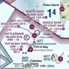
|
| Airport distance calculator |
|---|
|
|
| Sunrise and sunset |
|---|
|
Times for 11-Jun-2026
| | Local
(UTC-4) | | Zulu
(UTC) |
|---|
| Morning civil twilight | | 05:23 | | 09:23 |
| Sunrise | | 05:57 | | 09:57 |
| Sunset | | 21:04 | | 01:04 |
| Evening civil twilight | | 21:38 | | 01:38 |
|
| Current date and time |
|---|
| Zulu (UTC) | 11-Jun-2026 05:10:38 |
|---|
| Local (UTC-4) | 11-Jun-2026 01:10:38 |
|---|
|
| METAR |
|---|
KPCW
11nm S | 110455Z AUTO 21006KT 10SM CLR 26/23 A2978 RMK AO2
|
CXHA
21nm N | 110400Z AUTO 19006KT 23/23 RMK AO1 SLP075 T02310231 51003
|
|
| TAF |
|---|
CYQG
36nm N | 110311Z 1103/1124 21010KT P6SM SCT050 TEMPO 1103/1105 P6SM -SHRA BKN040 FM110500 21007KT P6SM BKN040 FM110800 22010G20KT 3SM -SHRA BR BKN015 OVC030 PROB30 1109/1111 2SM +TSRA BR BKN008 OVC015CB FM111600 24010G20KT P6SM BKN020 BECMG 1116/1118 BKN030 FM112000 25007KT P6SM BKN040 BECMG 1122/1124 24012KT RMK FCST BASED ON AUTO OBS. NXT FCST BY 110600Z
|
KDTW
40nm NW | 110218Z 1102/1206 18007KT P6SM SCT045 BKN070 OVC250 TEMPO 1107/1110 4SM -TSRA OVC030CB FM111000 20005KT 4SM BR SCT025 FM111400 24012KT P6SM SCT040 FM111900 22012G20KT P6SM BKN045 OVC100
|
KDET
44nm N | 110220Z 1102/1124 20007KT P6SM SCT045 BKN070 OVC250 TEMPO 1107/1110 4SM -TSRA OVC030CB FM111000 20005KT 4SM BR SCT025 FM111400 24012KT P6SM SCT040 FM111900 22012G20KT P6SM BKN045 OVC100
|
|
| NOTAMs |
|---|
NOTAMs are issued by the DoD/FAA and will open in a separate window not controlled by AirNav.
|
|


