FAA INFORMATION EFFECTIVE 07 AUGUST 2025
Location
| FAA Identifier: | 3W2 |
| Lat/Long: | 41-38-12.0000N 082-49-42.0000W
41-38.200000N 082-49.700000W
41.6366667,-82.8283333
(estimated) |
| Elevation: | 595 ft. / 181.4 m (surveyed) |
| Variation: | 07W (2000) |
| From city: | 1 mile SW of PUT IN BAY, OH |
| Time zone: | UTC -4 (UTC -5 during Standard Time) |
| Zip code: | 43456 |
Airport Operations
| Airport use: | Open to the public |
| Activation date: | 12/1938 |
| Control tower: | no |
| ARTCC: | CLEVELAND CENTER |
| FSS: | CLEVELAND FLIGHT SERVICE STATION |
| NOTAMs facility: | CLE (NOTAM-D service available) |
| Attendance: | IREG |
| Wind indicator: | yes |
| Segmented circle: | yes |
| Beacon: | white-green (lighted land airport)
Operates sunset to sunrise. |
| Landing fee: | yes, PRKG/RAMP FEES FOR ALL PVT & COML ACFT; ALL PILOTS ARE RQRD TO CK IN AT ARPT OFC AT TIME OF ARR; ALL ACFT RQRD TO SHUT DOWN ENGINE(S) WHEN ENPLANING/DEPLANING PAX. |
Airport Communications
| CTAF/UNICOM: | 122.8 |
| WX AWOS-3 at PCW (7 nm S): | 118.775 (419-734-9955) |
Nearby radio navigation aids
| VOR radial/distance | | VOR name | | Freq | | Var |
|---|
| DJBr304/34.3 | | DRYER VOR/DME | | 113.60 | | 05W |
| CRLr134/37.4 | | CARLETON VOR/DME | | 115.70 | | 03W |
| NDB name | | Hdg/Dist | | Freq | | Var | | ID |
|---|
| TIFFIN | | 033/36.9 | | 269 | | 05W | | TII | - .. .. |
Airport Services
| Parking: | hangars and tiedowns |
| Airframe service: | MAJOR |
| Powerplant service: | MAJOR |
| Bottled oxygen: | NONE |
| Bulk oxygen: | NONE |
Runway Information
Runway 3/21
| Dimensions: | 2870 x 75 ft. / 875 x 23 m |
| Surface: | asphalt, in good condition |
| RUNWAY 3 | | RUNWAY 21 |
| Latitude: | 41-38.001702N | | 41-38.398105N |
| Longitude: | 082-49.870983W | | 082-49.528005W |
| Elevation: | 592.2 ft. | | 594.5 ft. |
| Traffic pattern: | right | | left |
| Displaced threshold: | 450 ft. | | 657 ft. |
| Markings: | basic, in good condition | | basic, in good condition |
| Runway end identifier lights: | no | | no |
| Touchdown point: | yes, no lights | | yes, no lights |
| Obstructions: | 61 ft. trees, 402 ft. from runway, 119 ft. left of centerline, 3:1 slope to clear
+0-5 FT FENCE, 200 FT DIST, 125 FT R, EXTDG TO 250 FT FM DTHR, 125 FT R. | | 5 ft. fence, 201 ft. from runway, 120 ft. left and right of centerline
+5 FENCE, 0-200 FT DIST, 115 FT L; ALSO +5 FT FENCE, 140-200 FT DIST, 115-125 FT R. |
Airport Ownership and Management from official FAA records
| Ownership: | Publicly-owned |
| Owner: | PUT IN BAY TOWNSHIP PORT AUTH
PO BOX 278
PUT IN BAY, OH 43456-0278
Phone 419-285-3371 |
| Manager: | BETH FURNER
1494 LANGRAM RD
PUT IN BAY, OH 43456-6721
Phone 419-285-3371 |
Additional Remarks
| - | FOR CD CTC CLEVELAND APCH AT 216-352-2323. |
| - | EXP MOD TURB ON APCH/DEP WHEN WIND EXCEEDS 10 KT. |
| - | ACFT LDG RWY 21 OR DEP RWY 03 RMN 1000 FT CLEAR OF PERRY'S MONUMENT 352 FT AGL (942 FT MSL) 1.3 NM NE OF ARPT. |
| - | ACFT OPS PROHIBITED DUSK-DAWN. |
| - | HELIPAD IS FOR TOUCHDOWN, LOADING, & LIFTOFF ONLY - PARK ON GRASS WEST & SW OF HELIPAD. |
| - | BIRDS, DEER, & OTR WILDLIFE INVOF ARPT. |
Instrument Procedures
There are no published instrument procedures at 3W2.
Some nearby airports with instrument procedures:
KPCW - Erie-Ottawa International Airport (7 nm S)
S24 - Sandusky County Regional Airport (23 nm SW)
14G - Fremont Airport (24 nm SW)
5A1 - Norwalk/Huron County Airport (27 nm SE)
KTDZ - Toledo Executive Airport (30 nm W)
|
|

Road maps at:
MapQuest
Bing
Google
| Aerial photo |
|---|
WARNING: Photo may not be current or correct
 Photo by David Newcomer
Photo taken 22-Sep-2017
from 3,000' altitude looking north.
Photo by David Newcomer
Photo taken 22-Sep-2017
from 3,000' altitude looking north.
Do you have a better or more recent aerial photo of Put in Bay Airport that you would like to share? If so, please send us your photo.
|
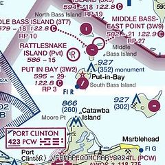
| Sectional chart |
|---|
|
| Airport distance calculator |
|---|
|
|
| Sunrise and sunset |
|---|
|
Times for 20-Aug-2025
| | Local
(UTC-4) | | Zulu
(UTC) |
|---|
| Morning civil twilight | | 06:17 | | 10:17 |
| Sunrise | | 06:46 | | 10:46 |
| Sunset | | 20:23 | | 00:23 |
| Evening civil twilight | | 20:53 | | 00:53 |
|
| Current date and time |
|---|
| Zulu (UTC) | 20-Aug-2025 21:10:32 |
|---|
| Local (UTC-4) | 20-Aug-2025 17:10:32 |
|---|
|
| METAR |
|---|
KPCW
7nm S | 202055Z AUTO 02013KT 10SM OVC016 21/19 A2999 RMK AO2
|
|
| TAF |
|---|
CYQG
39nm N | 201740Z 2018/2118 35010G20KT P6SM OVC015 TEMPO 2018/2106 OVC025 BECMG 2018/2020 03010G20KT FM210600 04010KT P6SM OVC015 RMK FCST BASED ON AUTO OBS. NXT FCST BY 210000Z
|
KDTW
42nm NW | 202026Z 2020/2124 36012KT P6SM OVC018 FM202200 02012KT P6SM BKN022 OVC050 FM210400 01007KT P6SM OVC025 FM210800 02006KT P6SM BKN015 OVC025 FM211600 02012KT P6SM BKN030
|
KTOL
44nm W | 201722Z 2018/2118 01010KT P6SM BKN025 FM210800 04010KT P6SM BKN025
|
KCLE
46nm E | 201722Z 2018/2124 36011KT P6SM BKN015 TEMPO 2018/2022 3SM -RA BR FM202200 03011KT P6SM BKN015 FM211700 04012KT P6SM BKN025 FM212100 04011KT P6SM BKN035
|
KDET
47nm N | 202027Z 2020/2118 36012KT P6SM OVC018 FM202100 02012KT P6SM BKN022 OVC050 FM210400 01007KT P6SM OVC025 FM210800 02006KT P6SM BKN015 OVC025 FM211600 02012KT P6SM BKN030
|
KYIP
48nm NW | 202027Z 2020/2118 36012KT P6SM OVC018 FM202200 02012KT P6SM BKN022 OVC050 FM210400 01007KT P6SM OVC025 FM210800 02006KT P6SM BKN015 OVC025 FM211600 02012KT P6SM BKN030
|
|
| NOTAMs |
|---|
NOTAMs are issued by the DoD/FAA and will open in a separate window not controlled by AirNav.
|
|


