FAA INFORMATION EFFECTIVE 27 NOVEMBER 2025
Location
| FAA Identifier: | 4J2 |
| Lat/Long: | 31-12-45.1605N 083-13-30.9236W
31-12.752675N 083-13.515393W
31.2125446,-83.2252566
(estimated) |
| Elevation: | 240.1 ft. / 73.2 m (surveyed) |
| Variation: | 03W (1995) |
| From city: | 1 mile E of NASHVILLE, GA |
| Time zone: | UTC -5 (UTC -4 during Daylight Saving Time) |
| Zip code: | 31639 |
Airport Operations
| Airport use: | Open to the public |
| Control tower: | no |
| ARTCC: | JACKSONVILLE CENTER |
| FSS: | MACON FLIGHT SERVICE STATION |
| NOTAMs facility: | MCN (NOTAM-D service available) |
| Attendance: | UNATTENDED |
| Wind indicator: | lighted |
| Segmented circle: | yes |
| Lights: | MIRL 10/28 PRESET LOW INTST DUSK-DAWN; TO INCREASE INTST AND ACTVT REIL RWY 10 & 28; PAPI RWY 10 & 28 - CTAF. |
| Beacon: | white-green (lighted land airport)
Operates sunset to sunrise. |
Airport Communications
| CTAF/UNICOM: | 122.7 |
| VALDOSTA APPROACH: | 126.6 ;EAST OF VAD 360-VAD 180 132.375 ;WEST OF VAD R-360 RADIAL |
| VALDOSTA DEPARTURE: | 126.6 ;EAST OF VAD 360-VAD 180 132.375 ;WEST OF VAD R-360 RADIAL |
| IC: | 126.6 ;EAST OF VAD 360-VAD 180 |
| WX AWOS-3PT at 15J (13 nm W): | 118.025 (229-896-4223) |
| WX AWOS-3PT at TMA (19 nm NW): | 118.525 (229-386-8937) |
- APCH/DEP SVC PRVDD BY JACKSONVILLE ARTCC ON FREQS 133.7/323.3(VALDOSTA RCAG) WHEN VALDOSTA APCH CTL CLSD.
Nearby radio navigation aids
| VOR radial/distance | | VOR name | | Freq | | Var |
|---|
| OTKr008/26.1 | | VALDOSTA VOR/DME | | 114.80 | | 02W |
| AYSr264/34.5 | | WAYCROSS VORTAC | | 112.40 | | 00E |
| NDB name | | Hdg/Dist | | Freq | | Var | | ID |
|---|
| FITZGERALD | | 177/24.3 | | 362 | | 05W | | SUR | ... ..- .-. |
| PATON | | 069/34.5 | | 245 | | 05W | | GTP | --. - .--. |
Airport Services
| Fuel available: | A |
| Parking: | tiedowns |
| Airframe service: | NONE |
| Powerplant service: | NONE |
| Bottled oxygen: | NONE |
| Bulk oxygen: | NONE |
Runway Information
Runway 10/28
| Dimensions: | 5002 x 75 ft. / 1525 x 23 m |
| Surface: | asphalt, in good condition |
| Weight bearing capacity: | |
| Runway edge lights: | medium intensity |
| RUNWAY 10 | | RUNWAY 28 |
| Latitude: | 31-12.775823N | | 31-12.729527N |
| Longitude: | 083-13.994645W | | 083-13.036140W |
| Elevation: | 238.2 ft. | | 232.9 ft. |
| Traffic pattern: | left | | left |
| Runway heading: | 096 magnetic, 093 true | | 276 magnetic, 273 true |
| Markings: | nonprecision, in good condition | | nonprecision, in good condition |
| Visual slope indicator: | 4-light PAPI on left (3.00 degrees glide path) | | 4-light PAPI on left (3.00 degrees glide path) |
| Runway end identifier lights: | yes | | yes |
| Touchdown point: | yes, no lights | | yes, no lights |
| Obstructions: | 28 ft. trees, 582 ft. from runway, 306 ft. left of centerline, 13:1 slope to clear
CTLNG OBSTN EXCEEDS A 45 DEG SLP. | | 87 ft. trees, 2375 ft. from runway, 552 ft. right of centerline, 25:1 slope to clear |
Airport Ownership and Management from official FAA records
| Ownership: | Publicly-owned |
| Owner: | BERRIEN COUNTY
201 N DAVIS ST, ROOM 198
NASHVILLE, GA 31639
Phone 229-686-5421 |
| Manager: | MARY ALICE MCGEE
P.O. BOX 217, ROOM 198
NASHVILLE, GA 31639
Phone 229-686-5421 |
Additional Remarks
| - | FOR CD CTC JACKSONVILLE ARTCC AT 904-845-1592. |
Instrument Procedures
NOTE: All procedures below are presented as PDF files. If you need a reader for these files, you should download the free Adobe Reader.NOT FOR NAVIGATION. Please procure official charts for flight.
FAA instrument procedures published for use from 27 November 2025 at 0901Z to 25 December 2025 at 0900Z.
IAPs - Instrument Approach Procedures |
|---|
| RNAV (GPS) RWY 10 **CHANGED** | |
download (209KB) |
| RNAV (GPS) RWY 28 **CHANGED** | |
download (223KB) |
| NOTE: Special Take-Off Minimums/Departure Procedures apply | |
download (302KB) |
Other nearby airports with instrument procedures:
15J - Cook County Airport (13 nm W)
KVAD - Moody Air Force Base (15 nm S)
KTMA - Henry Tift Myers Airport (19 nm NW)
KDQH - Douglas Municipal Airport (25 nm NE)
KHOE - Homerville Airport (25 nm E)
|
|

Road maps at:
MapQuest
Bing
Google
| Aerial photo |
|---|
WARNING: Photo may not be current or correct
 Photo courtesy of AirNav, LLC
Photo taken 01-Apr-2011
looking east.
Photo courtesy of AirNav, LLC
Photo taken 01-Apr-2011
looking east.
Do you have a better or more recent aerial photo of Berrien County Airport that you would like to share? If so, please send us your photo.
|
| Sectional chart |
|---|
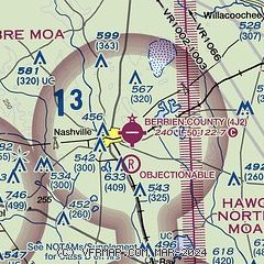
|
| Airport distance calculator |
|---|
|
|
| Sunrise and sunset |
|---|
|
Times for 24-Dec-2025
| | Local
(UTC-5) | | Zulu
(UTC) |
|---|
| Morning civil twilight | | 07:03 | | 12:03 |
| Sunrise | | 07:30 | | 12:30 |
| Sunset | | 17:35 | | 22:35 |
| Evening civil twilight | | 18:02 | | 23:02 |
|
| Current date and time |
|---|
| Zulu (UTC) | 24-Dec-2025 09:25:43 |
|---|
| Local (UTC-5) | 24-Dec-2025 04:25:43 |
|---|
|
| METAR |
|---|
KVAD
15nm S | 240855Z AUTO 00000KT 10SM CLR M A3027 RMK AO2 SLPNO ALSTG ESTMD 56003 $
|
KTMA
19nm NW | 240855Z AUTO 00000KT 1/2SM FG CLR 12/12 A3031 RMK AO2 T01150115 58001
|
KDQH
25nm NE | 240855Z AUTO 00000KT 10SM CLR 13/12 A3030 RMK AO2 T01270119
|
KHOE
25nm E | 240855Z AUTO 00000KT 10SM CLR 11/10 A3029 RMK AO2 T01090100
|
KVLD
27nm S | 240853Z AUTO 00000KT 5SM BR FEW009 11/10 A3030 RMK AO2 SLP266 T01060100 57001
|
KFZG
28nm N | 240855Z AUTO 27003KT 10SM CLR 13/12 A3029 RMK AO2 T01280119
|
|
| NOTAMs |
|---|
NOTAMs are issued by the DoD/FAA and will open in a separate window not controlled by AirNav.
|
|


