FAA INFORMATION EFFECTIVE 20 MARCH 2025
Location
| FAA Identifier: | AIO |
| Lat/Long: | 41-24-13.8000N 095-02-55.5000W
41-24.230000N 095-02.925000W
41.4038333,-95.0487500
(estimated) |
| Elevation: | 1164.9 ft. / 355.1 m (surveyed) |
| Variation: | 04E (1995) |
| From city: | 2 miles W of ATLANTIC, IA |
| Time zone: | UTC -5 (UTC -6 during Standard Time) |
| Zip code: | 50022 |
Airport Operations
| Airport use: | Open to the public |
| Activation date: | 05/1941 |
| Control tower: | no |
| ARTCC: | MINNEAPOLIS CENTER |
| FSS: | FORT DODGE FLIGHT SERVICE STATION |
| NOTAMs facility: | AIO (NOTAM-D service available) |
| Attendance: | MON-FRI 0800-1700, ALL SAT 0800-1200
FOR SVC AFT HRS CALL 712-267-3263 |
| Pattern altitude: | 1964.9 ft. MSL |
| Wind indicator: | lighted |
| Segmented circle: | no |
| Lights: | ACTVT MIRL RYS 02/20 & 12/30 AND REIL AND PAPI RYS 02/20- CTAF. |
| Beacon: | white-green (lighted land airport)
Operates sunset to sunrise. |
Airport Communications
| CTAF/UNICOM: | 122.7 |
| WX AWOS-3: | 127.825 (712-243-2748) |
| WX AWOS-3 at HNR (17 nm NW): | 118.325 (712-744-4400) |
| WX AWOS-3 at ADU (19 nm N): | 118.075 (712-563-2101) |
- APCH/DEP SVC PRVDD BY MINNEAPOLIS ARTCC ON FREQS 119.6/290.4 (OMAHA RCAG).
Nearby radio navigation aids
| VOR radial/distance | | VOR name | | Freq | | Var |
|---|
| OVRr057/34.1 | | OMAHA VORTAC | | 116.30 | | 08E |
Airport Services
| Fuel available: | 100LL JET-A |
| Parking: | hangars and tiedowns |
| Airframe service: | MINOR |
| Powerplant service: | MINOR |
| Bottled oxygen: | NONE |
| Bulk oxygen: | NONE |
Runway Information
Runway 2/20
| Dimensions: | 5000 x 75 ft. / 1524 x 23 m |
| Surface: | concrete, in good condition |
| Weight bearing capacity: | |
| Runway edge lights: | medium intensity |
| RUNWAY 2 | | RUNWAY 20 |
| Latitude: | 41-23.709532N | | 41-24.473985N |
| Longitude: | 095-03.245082W | | 095-02.839252W |
| Elevation: | 1145.9 ft. | | 1149.0 ft. |
| Traffic pattern: | left | | left |
| Runway heading: | 018 magnetic, 022 true | | 198 magnetic, 202 true |
| Markings: | nonprecision, in fair condition | | nonprecision, in fair condition |
| Visual slope indicator: | 2-light PAPI on left (3.00 degrees glide path) | | 2-light PAPI on left (3.00 degrees glide path) |
| Runway end identifier lights: | yes | | yes |
| Touchdown point: | yes, no lights | | yes, no lights |
Runway 12/30
| Dimensions: | 3132 x 75 ft. / 955 x 23 m |
| Surface: | asphalt, in good condition |
| Weight bearing capacity: | | PCN 6 /F/C/X/U | | Single wheel: | 12.5 |
|
| Runway edge lights: | medium intensity |
| RUNWAY 12 | | RUNWAY 30 |
| Latitude: | 41-24.590192N | | 41-24.309025N |
| Longitude: | 095-03.025442W | | 095-02.451312W |
| Elevation: | 1164.9 ft. | | 1143.8 ft. |
| Traffic pattern: | left | | left |
| Runway heading: | 119 magnetic, 123 true | | 299 magnetic, 303 true |
| Displaced threshold: | 290 ft. | | no |
| Declared distances: | TORA:3132 TODA:3132 ASDA:3132 LDA:2842 | | TORA:3132 TODA:3132 ASDA:3132 LDA:3132 |
| Markings: | nonprecision, in good condition | | nonprecision, in good condition |
| Runway end identifier lights: | no | | no |
| Touchdown point: | yes, no lights | | yes, no lights |
| Obstructions: | 73 ft. tree, 1287 ft. from runway, 75 ft. right of centerline, 14:1 slope to clear
13 FT ROAD @ 80 FT ON CNTRLN. | | 15 ft. brush, 385 ft. from runway, 110 ft. right of centerline, 20:1 slope to clear |
Airport Ownership and Management from official FAA records
| Ownership: | Publicly-owned |
| Owner: | CITY OF ATLANTIC
23 E. 4TH ST.
ATLANTIC, IA 50022
Phone 712-243-4810 |
| Manager: | BARRY REID
59706 AIRPORT RD
ATLANTIC, IA 50022
Phone 712-243-3056
EMAIL ADDRESS: AIRWORKSAIO@GMAIL.COM (ALL LOWER CASE) |
Additional Remarks
| - | CREEK 200 FT FM RY END 30. |
| - | FOR CD CTC MINNEAPOLIS ARTCC AT 651-463-5588. |
Instrument Procedures
NOTE: All procedures below are presented as PDF files. If you need a reader for these files, you should download the free Adobe Reader.NOT FOR NAVIGATION. Please procure official charts for flight.
FAA instrument procedures published for use from 20 March 2025 at 0901Z to 17 April 2025 at 0900z.
IAPs - Instrument Approach Procedures |
|---|
| RNAV (GPS) RWY 02 | |
download (261KB) |
| RNAV (GPS) RWY 20 | |
download (222KB) |
| NOTE: Special Alternate Minimums apply | |
download (126KB) |
| NOTE: Special Take-Off Minimums/Departure Procedures apply | |
download (158KB) |
Other nearby airports with instrument procedures:
KHNR - Harlan Municipal Airport (17 nm NW)
KADU - Audubon County Airport (19 nm N)
KRDK - Red Oak Municipal Airport (25 nm S)
KGFZ - Greenfield Municipal Airport (28 nm E)
KCRZ - Corning Municipal Airport (28 nm SE)
|
|

Road maps at:
MapQuest
Bing
Google
| Aerial photo |
|---|
WARNING: Photo may not be current or correct
 Photo taken 06-Oct-2006
Do you have a better or more recent aerial photo of Atlantic Municipal Airport that you would like to share? If so, please send us your photo.
|
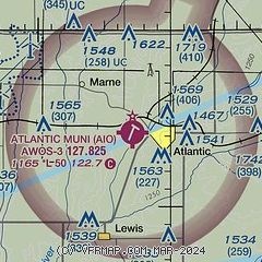
| Sectional chart |
|---|
|
| Airport distance calculator |
|---|
|
|
| Sunrise and sunset |
|---|
|
Times for 15-Apr-2025
| | Local
(UTC-5) | | Zulu
(UTC) |
|---|
| Morning civil twilight | | 06:13 | | 11:13 |
| Sunrise | | 06:41 | | 11:41 |
| Sunset | | 19:59 | | 00:59 |
| Evening civil twilight | | 20:28 | | 01:28 |
|
| Current date and time |
|---|
| Zulu (UTC) | 15-Apr-2025 20:59:02 |
|---|
| Local (UTC-5) | 15-Apr-2025 15:59:02 |
|---|
|
| METAR |
|---|
| KAIO | 152035Z AUTO 30013KT 10SM CLR 16/M06 A3015 RMK AO2
|
KHNR
17nm NW | 152035Z AUTO 29014G21KT 10SM CLR 16/M06 A3015 RMK A01
|
KADU
19nm N | 152035Z AUTO 31009G19KT 10SM SCT015 BKN041 OVC070 16/M16 A3016 RMK AO2 PWINO
|
|
| TAF |
|---|
KOMA
39nm W | 151928Z 1519/1618 29011KT P6SM SKC FM160200 14006KT P6SM SKC FM161100 14009KT P6SM FEW250 WS013/21037KT FM161400 16012G21KT P6SM FEW250
|
KOFF
43nm SW | 151800Z 1518/1624 29010G20KT 9999 SKC QNH3012INS BECMG 1523/1524 15006KT 9999 SKC QNH3007INS BECMG 1605/1606 15009KT 9999 FEW250 510102 QNH2994INS BECMG 1613/1614 17012G18KT 9999 SKC QNH2981INS TX21/1618Z TN06/1612Z
|
|
| NOTAMs |
|---|
NOTAMs are issued by the DoD/FAA and will open in a separate window not controlled by AirNav.
|
|


