FAA INFORMATION EFFECTIVE 07 AUGUST 2025
Location
| FAA Identifier: | APA |
| Lat/Long: | 39-34-12.4270N 104-50-57.4550W
39-34.207117N 104-50.957583W
39.5701186,-104.8492931
(estimated) |
| Elevation: | 5884.9 ft. / 1793.7 m (surveyed) |
| Variation: | 08E (2015) |
| From city: | 15 miles SE of DENVER, CO |
| Time zone: | UTC -6 (UTC -7 during Standard Time) |
| Zip code: | 80112 |
Airport Operations
| Airport use: | Open to the public |
| Activation date: | 03/1968 |
| Control tower: | yes |
| ARTCC: | DENVER CENTER |
| FSS: | DENVER FLIGHT SERVICE STATION |
| NOTAMs facility: | APA (NOTAM-D service available) |
| Attendance: | CONTINUOUS |
| Wind indicator: | lighted |
| Segmented circle: | no |
| Lights: | SS-SR |
| Beacon: | white-green (lighted land airport)
Operates sunset to sunrise. |
| International operations: | H24 US CUSTOMS - 303-768-0309. |
Airport Communications
| UNICOM: | 122.95 |
| ATIS: | 120.3 |
| WX ASOS: | PHONE 720-873-2799 |
| CENTENNIAL GROUND: | 121.8 |
| CENTENNIAL TOWER: | 118.9 |
| DENVER APPROACH: | 132.75 |
| DENVER DEPARTURE: | 132.75 |
| CLEARANCE DELIVERY: | 128.6 |
| BRNKO RNAV STAR: | 127.05 |
| DANDD STAR: | 120.35 |
| DUNNN RNAV STAR: | 128.45 |
| LARKS: | 120.35 |
| POWDR STAR: | 120.35 |
| QUAIL STAR: | 120.35 |
| RAMMS STAR: | 120.35 |
| TOMSN STAR: | 119.3 |
| ZOMBZ RNAV STAR: | 128.45 |
| WX ASOS at DEN (19 nm NE): | PHONE 719-204-1223 |
| WX AWOS-3 at CFO (19 nm NE): | 119.025 (303-261-9104) |
- FREQ 121.5 NOT AVBL.
- ADVISE GROUND CONTROL WHEN READY FOR DEPARTURE. GROUND CONTROL WILL ADVISE WHEN TO MONITOR THE TOWER FREQUENCY.
- COMMUNICATIONS PRVDD BY DENVER RADIO ON FREQ 122.2 (DENVER RCO).
Nearby radio navigation aids
| VOR radial/distance | | VOR name | | Freq | | Var |
|---|
| FQFr225/12.8 | | FALCON VORTAC | | 116.30 | | 11E |
| DENr203/17.0 | | DENVER VOR/DME | | 117.90 | | 08E |
| DVVr200/22.1 | | MILE HIGH VORTAC | | 114.70 | | 08E |
| BJCr136/24.5 | | JEFFCO VOR/DME | | 115.40 | | 11E |
| BRKr337/38.9 | | BLACK FOREST VOR/DME | | 112.50 | | 08E |
Airport Services
| Fuel available: | 100LL JET-A UL94
100LL:SELF SERVE FUEL AVBL. |
| Parking: | hangars and tiedowns |
| Airframe service: | MAJOR |
| Powerplant service: | MAJOR |
| Bulk oxygen: | HIGH/LOW |
Runway Information
Runway 17L/35R
| Dimensions: | 10001 x 100 ft. / 3048 x 30 m |
| Surface: | asphalt/grooved, in good condition |
| Weight bearing capacity: | | PCN 26 /F/C/X/T | | Single wheel: | 56.0 | | Double wheel: | 75.0 |
|
| Runway edge lights: | medium intensity |
| RUNWAY 17L | | RUNWAY 35R |
| Latitude: | 39-35.048662N | | 39-33.402900N |
| Longitude: | 104-51.088380W | | 104-51.012350W |
| Elevation: | 5793.0 ft. | | 5884.9 ft. |
| Traffic pattern: | left | | right |
| Runway heading: | 170 magnetic, 178 true | | 350 magnetic, 358 true |
| Markings: | precision, in good condition | | precision, in good condition |
| Visual slope indicator: | 4-light PAPI on left (3.00 degrees glide path) | | 4-light PAPI on left (3.00 degrees glide path) |
| Approach lights: | | | MALSR: 1,400 foot medium intensity approach lighting system with runway alignment indicator lights |
| Touchdown point: | yes, no lights | | yes, no lights |
| Instrument approach: | | | ILS/DME |
| Obstructions: | none | | 542 ft. pline, lighted, 17903 ft. from runway, 2516 ft. left of centerline, 32:1 slope to clear |
Runway 17R/35L
| Dimensions: | 7001 x 75 ft. / 2134 x 23 m |
| Surface: | asphalt/grooved, in good condition |
| Weight bearing capacity: | |
| Runway edge lights: | medium intensity |
| RUNWAY 17R | | RUNWAY 35L |
| Latitude: | 39-34.739158N | | 39-33.587100N |
| Longitude: | 104-51.223140W | | 104-51.169833W |
| Elevation: | 5803.7 ft. | | 5868.7 ft. |
| Traffic pattern: | right | | left |
| Runway heading: | 170 magnetic, 178 true | | 350 magnetic, 358 true |
| Markings: | nonprecision, in good condition | | nonprecision, in good condition |
| Visual slope indicator: | 4-light PAPI on left (3.00 degrees glide path) | | 4-light PAPI on right (3.00 degrees glide path) |
| Runway end identifier lights: | yes | | yes |
| Touchdown point: | yes, no lights | | yes, no lights |
| Obstructions: | none | | 19 ft. fence, 542 ft. from runway, 267 ft. left of centerline, 18:1 slope to clear |
Runway 10/28
| Dimensions: | 4800 x 75 ft. / 1463 x 23 m |
| Surface: | asphalt/grooved, in good condition |
| Weight bearing capacity: | | PCN 17 /F/A/Y/T | | Single wheel: | 12.5 |
|
| Runway edge lights: | medium intensity |
| RUNWAY 10 | | RUNWAY 28 |
| Latitude: | 39-34.373745N | | 39-34.090992N |
| Longitude: | 104-50.892795W | | 104-49.939033W |
| Elevation: | 5824.1 ft. | | 5793.8 ft. |
| Traffic pattern: | left | | left |
| Runway heading: | 103 magnetic, 111 true | | 283 magnetic, 291 true |
| Displaced threshold: | 400 ft. | | no |
| Markings: | nonprecision, in good condition | | nonprecision, in good condition |
| Visual slope indicator: | 2-light PAPI on left (3.00 degrees glide path) | | 2-light PAPI on left (3.00 degrees glide path) |
| Runway end identifier lights: | | | yes |
| Touchdown point: | yes, no lights | | yes, no lights |
Helipad H1
| Dimensions: | 50 x 50 ft. / 15 x 15 m |
| Surface: | concrete, in good condition |
| Runway edge lights: | PERI |
| Operational restrictions: | TLOF 50X50 FT; FATO 50X50 FT; INGRESS/EGRESS 270. |
| Latitude: | 39-34.516667N | | |
| Longitude: | 104-50.266667W | | |
| Elevation: | 5825.0 ft. | | |
| Traffic pattern: | left | | left |
Airport Ownership and Management from official FAA records
| Ownership: | Publicly-owned |
| Owner: | ARAPAHOE CO PUBLIC ARPT AUTH
7800 S PEORIA ST
ENGLEWOOD, CO 80112
Phone 303-790-0598
AFT HR - 303-877-7307. |
| Manager: | MIKE FRONAPFEL
7565 SOUTH PEORIA ST, UNIT D9
ENGLEWOOD, CO 80112
Phone 303-790-0598 |
Additional Remarks
| A39-17R/35L | PCR VALUE: 339/F/C/X/T |
| A30A-H1 | H24 HELI SVC - 303-799-0079. |
| A30A-17L | NMRS FLOOD LGTS 1/2 SM N OF THR; SS-2400. |
| - | ALL ACFT BLO CERT 70000 LB MAX GROSS TKOF WT & STAGE III ACFT UP TO CERT 75000 LB MAX GROSS TKOF WT MAY OPR; ONE-TIME EXCEPTION AUZD BY EXEC DIR. |
| - | HELI OPS CTC FBO FOR LNDG ZONE LCTN; HELI OPS ON FRONT RAMP NOT ADVISED. |
| - | ADZY DENSITY ALT DSPL LCTD C-1, A-1 & A-18. |
| - | CTN: ENSURE PROPER RWY ALNMT; CLOSE SPACED PARL RWYS. ARPT SAFETY VIDEO - HTTPS://WWW.FAA.GOV/AIRPORTS/RUNWAY_SAFETY/VIDEOS/APA/ |
| - | MULT LRG PWR LINES APRXLY 3NM S OF RWY 35R & RWY 35L. |
| - | NOISE ABATEMENT PROCS IN EFCT. ALL ACFT AVOID NOISE SENSITIVE AREAS 1 NM NORTH AND WEST OF ARPT AND 1 NM SOUTHEAST OF ARPT. RWY 17R-35L CLSD TFC REMAIN SOUTH OF ARAPAHOE ROAD, EAST OF I-25, AND NORTH OF LINCOLN AVE. QUIET HRS 2200-0700L. TBJT ACFT USE NBAA PROFILES. NOISE OFFICE/303-790-0598. |
| - | +71 FT BLDG LCTD 1920 FT ESE OF RY 28 THLD 440 FT LT OF CTLN 24:1 GLD SLP. |
| - | WATERFOWL ON & INVOF ARPT. |
| - | NMRS CRANES INVOF ARPT. |
| - | +190 FT TWR LCTD 1800 FT ENE OF RY 17L THLD. |
Instrument Procedures
NOTE: All procedures below are presented as PDF files. If you need a reader for these files, you should download the free Adobe Reader.NOT FOR NAVIGATION. Please procure official charts for flight.
FAA instrument procedures published for use from 07 August 2025 at 0901Z to 04 September 2025 at 0900z.
STARs - Standard Terminal Arrivals |
|---|
| BRNKO FOUR (RNAV) | |
2 pages:
[1] [2] (289KB) |
| BRNKO FOUR (RNAV), CONT.2 | |
download (252KB) |
| DANDD ONE | |
2 pages:
[1] [2] (324KB) |
| DUNNN SIX (RNAV) | |
2 pages:
[1] [2] (312KB) |
| DUNNN SIX (RNAV), CONT.2 | |
download (256KB) |
| LANDR THREE | |
2 pages:
[1] [2] (346KB) |
| LARKS THREE | |
2 pages:
[1] [2] (351KB) |
| PINNR THREE (RNAV) | |
2 pages:
[1] [2] (364KB) |
| POWDR ONE | |
2 pages:
[1] [2] (325KB) |
| QUAIL ONE | |
download (249KB) |
| RAMMS EIGHT | |
2 pages:
[1] [2] (308KB) |
| TOMSN NINE | |
2 pages:
[1] [2] (338KB) |
| ZOMBZ SIX (RNAV) | |
2 pages:
[1] [2] (437KB) |
IAPs - Instrument Approach Procedures |
|---|
| ILS OR LOC RWY 35R **CHANGED** | |
download (271KB) |
| RNAV (RNP) Z RWY 17L **CHANGED** | |
download (203KB) |
| RNAV (GPS) RWY 28 **CHANGED** | |
download (218KB) |
| RNAV (GPS) RWY 35R **CHANGED** | |
download (224KB) |
| RNAV (GPS) Y RWY 17L **CHANGED** | |
download (192KB) |
| NOTE: Special Alternate Minimums apply | |
download (145KB) |
Departure Procedures |
|---|
| DENVER THREE **NEW** | |
2 pages:
[1] [2] (297KB) |
| ECHOO ONE (RNAV) | |
2 pages:
[1] [2] (305KB) |
| MRSHH TWO (RNAV) | |
2 pages:
[1] [2] (300KB) |
| PIKES THREE **NEW** | |
2 pages:
[1] [2] (325KB) |
| PLAINS TWO **NEW** | |
2 pages:
[1] [2] (455KB) |
| ROCKIES SEVEN **NEW** | |
2 pages:
[1] [2] (402KB) |
| SKYEE ONE (RNAV) | |
2 pages:
[1] [2] (306KB) |
| WNGSS ONE (RNAV) | |
2 pages:
[1] [2] (348KB) |
| YELLOWSTONE FIVE **NEW** | |
2 pages:
[1] [2] (402KB) |
| NOTE: Special Take-Off Minimums/Departure Procedures apply | |
download (299KB) |
Other nearby airports with instrument procedures:
KBKF - Buckley Space Force Base (9 nm NE)
KDEN - Denver International Airport (19 nm NE)
KCFO - Colorado Air and Space Port Airport (19 nm NE)
KBJC - Rocky Mountain Metro Airport (24 nm NW)
KEIK - Erie Municipal Airport (28 nm N)
|
|

Road maps at:
MapQuest
Bing
Google
| Aerial photo |
|---|
WARNING: Photo may not be current or correct
 Photo by Mitch Bowers imagewerx.us
Photo taken 01-Feb-2017
looking east.
Photo by Mitch Bowers imagewerx.us
Photo taken 01-Feb-2017
looking east.
Do you have a better or more recent aerial photo of Centennial Airport that you would like to share? If so, please send us your photo.
|
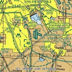
| Sectional chart |
|---|
|
CAUTION: Diagram may not be current
 Download PDF
of official airport diagram from the FAA
| Airport distance calculator |
|---|
|
|
| Sunrise and sunset |
|---|
|
Times for 20-Aug-2025
| | Local
(UTC-6) | | Zulu
(UTC) |
|---|
| Morning civil twilight | | 05:49 | | 11:49 |
| Sunrise | | 06:17 | | 12:17 |
| Sunset | | 19:48 | | 01:48 |
| Evening civil twilight | | 20:16 | | 02:16 |
|
| Current date and time |
|---|
| Zulu (UTC) | 20-Aug-2025 22:25:34 |
|---|
| Local (UTC-6) | 20-Aug-2025 16:25:34 |
|---|
|
| METAR |
|---|
| KAPA | 202153Z 12015G20KT 10SM FEW100 FEW220 33/08 A3023 RMK AO2 SLP153 T03330083
|
KBKF
10nm NE | 202158Z 13012KT 10SM FEW090 FEW140 SCT220 35/07 A3021 RMK AO2A SLP131 T03480069
|
KDEN
18nm NE | 202153Z 10008G23KT 10SM FEW110 FEW140 FEW250 34/08 A3021 RMK AO2 SLP136 T03390083
|
KCFO
19nm NE | 202147Z 11010G18KT 10SM CLR 34/04 A3023
|
|
| TAF |
|---|
| KAPA | 201720Z 2018/2118 13012KT P6SM FEW100 FM202100 10012G17KT P6SM FEW100 FM210100 14013G18KT P6SM SCT100 FM210400 18013G18KT P6SM SKC FM210900 19007KT P6SM SKC FM211400 24007KT P6SM FEW220 FM211600 VRB05KT P6SM FEW110
|
KBKF
10nm NE | 201700Z 2017/2123 VRB06KT 9999 FEW140 SCT220 QNH3031INS BECMG 2100/2102 16010G25KT 9999 VCSH FEW150 SCT230 QNH3020INS BECMG 2109/2110 18010KT 9999 NSW SKC QNH3021INS TX33/2023Z TN18/2113Z
|
KDEN
18nm NE | 201720Z 2018/2124 13011G17KT P6SM FEW110 FM202100 10012G18KT P6SM FEW110 FM210100 14014KT P6SM SCT110 FM210500 19012KT P6SM SKC FM211300 24008KT P6SM FEW220 FM211600 VRB05KT P6SM FEW110 FM211900 07010KT P6SM FEW110 SCT150
|
|
| NOTAMs |
|---|
NOTAMs are issued by the DoD/FAA and will open in a separate window not controlled by AirNav.
|
|


