FAA INFORMATION EFFECTIVE 17 APRIL 2025
Location
| FAA Identifier: | CYW |
| Lat/Long: | 39-23-13.7000N 097-09-26.0000W
39-23.228333N 097-09.433333W
39.3871389,-97.1572222
(estimated) |
| Elevation: | 1208.9 ft. / 368.5 m (surveyed) |
| Variation: | 04E (2010) |
| From city: | 2 miles W of CLAY CENTER, KS |
| Time zone: | UTC -5 (UTC -6 during Standard Time) |
| Zip code: | 67432 |
Airport Operations
| Airport use: | Open to the public |
| Activation date: | 04/1942 |
| Control tower: | no |
| ARTCC: | KANSAS CITY CENTER |
| FSS: | WICHITA FLIGHT SERVICE STATION |
| NOTAMs facility: | ICT (NOTAM-D service available) |
| Attendance: | 0800-1700
FOR SVC AFT DUSK CALL CELL 785-757-4551. |
| Wind indicator: | lighted |
| Segmented circle: | yes |
| Lights: | RY 17/35 MIRL PRESET LOW INTST DUSK-2200; TO INCR INTST ACTVT - CTAF. AFT 2200 ACTVT - CTAF. ACTIVE REILS AND PAPIS - CTAF. RWY 17/35 ACTVT REILS AND PAPIS -CTAF. |
| Beacon: | white-green (lighted land airport)
Operates sunset to sunrise. |
Airport Communications
| CTAF/UNICOM: | 122.8 |
| WX AWOS-3T: | 119.95 (785-777-2507) |
| MARSHALL AAF GCA APPROACH: | 121.25 |
| MARSHALL AAF GCA DEPARTURE: | 121.25 |
- APCH/DEP CTL SVC PRVDD BY KANSAS CITY ARTCC (ZKC) ON FREQS 127.35/257.975 (MANHATTAN RCAG) WHEN MARSHALL APCH CTL (FRI) CLSD.
Nearby radio navigation aids
| VOR radial/distance | | VOR name | | Freq | | Var |
|---|
| MHKr299/26.9 | | MANHATTAN VOR/DME | | 110.20 | | 04E |
| FRIr325/(28.6) | | FORT RILEY VOR | | 109.40 | | 06E |
| SLNr031/35.1 | | SALINA VORTAC | | 117.10 | | 07E |
Airport Services
| Fuel available: | 100LL |
| Parking: | hangars and tiedowns |
| Airframe service: | MAJOR |
| Powerplant service: | MAJOR |
| Bottled oxygen: | NONE |
| Bulk oxygen: | NONE |
Runway Information
Runway 17/35
| Dimensions: | 4197 x 75 ft. / 1279 x 23 m |
| Surface: | asphalt, in fair condition |
| Weight bearing capacity: | | PCN 6 /F/C/Y/U | | Single wheel: | 12.0 | | Double wheel: | 15.0 |
|
| Runway edge lights: | medium intensity |
| RUNWAY 17 | | RUNWAY 35 |
| Latitude: | 39-23.573603N | | 39-22.882590N |
| Longitude: | 097-09.422507W | | 097-09.443152W |
| Elevation: | 1208.7 ft. | | 1206.7 ft. |
| Traffic pattern: | left | | left |
| Runway heading: | 177 magnetic, 181 true | | 357 magnetic, 001 true |
| Displaced threshold: | 202 ft. | | 227 ft. |
| Markings: | numbers only, in fair condition | | numbers only, in fair condition |
| Visual slope indicator: | 2-light PAPI on left (2.75 degrees glide path) | | 2-light PAPI on left (2.75 degrees glide path) |
| Runway end identifier lights: | yes | | yes |
| Touchdown point: | yes, no lights | | yes, no lights |
| Obstructions: | 26 ft. tree, 853 ft. from runway, 349 ft. left of centerline, 25:1 slope to clear
RWY 17 22:1 TO DSPLCD THR. | | 36 ft. pole, 634 ft. from runway, 453 ft. both sides of centerline, 12:1 slope to clear |
Airport Ownership and Management from official FAA records
| Ownership: | Publicly-owned |
| Owner: | CITY OF CLAY CENTER
427 COURT ST.
CLAY CENTER, KS 67432
Phone 785-632-5454 |
| Manager: | SCOTT HEINEN
1226 104TH ROAD
SENECA, KS 66538
Phone (800) 760-4964 |
Additional Remarks
| - | FOR CD CTC MARSHALL APCH AT 785-239-2118. WHEN MARSHALL APCH IS CLSD, CTC KANSAS CITY ARTCC AT 913-254-8508. |
Instrument Procedures
NOTE: All procedures below are presented as PDF files. If you need a reader for these files, you should download the free Adobe Reader.NOT FOR NAVIGATION. Please procure official charts for flight.
FAA instrument procedures published for use from 17 April 2025 at 0901Z to 15 May 2025 at 0900z.
IAPs - Instrument Approach Procedures |
|---|
| RNAV (GPS) RWY 17 **CHANGED** | |
download (175KB) |
| RNAV (GPS) RWY 35 **CHANGED** | |
download (213KB) |
| NOTE: Special Take-Off Minimums/Departure Procedures apply | |
download (147KB) |
Other nearby airports with instrument procedures:
K38 - Washington County Veteran's Memorial Airport (21 nm N)
KCNK - Blosser Municipal Airport (25 nm NW)
3JC - Freeman Field Airport (25 nm SE)
KMHK - Manhattan Regional Airport (27 nm SE)
KFRI - Marshall Army Airfield (27 nm SE)
|
|

Road maps at:
MapQuest
Bing
Google
| Aerial photo |
|---|
WARNING: Photo may not be current or correct

Do you have a better or more recent aerial photo of Clay Center Municipal Airport that you would like to share? If so, please send us your photo.
|
| Sectional chart |
|---|
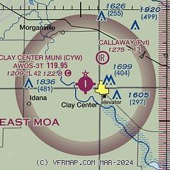
|
| Airport distance calculator |
|---|
|
|
| Sunrise and sunset |
|---|
|
Times for 22-Apr-2025
| | Local
(UTC-5) | | Zulu
(UTC) |
|---|
| Morning civil twilight | | 06:14 | | 11:14 |
| Sunrise | | 06:43 | | 11:43 |
| Sunset | | 20:12 | | 01:12 |
| Evening civil twilight | | 20:40 | | 01:40 |
|
| Current date and time |
|---|
| Zulu (UTC) | 22-Apr-2025 21:13:08 |
|---|
| Local (UTC-5) | 22-Apr-2025 16:13:08 |
|---|
|
| TAF |
|---|
KMHK
27nm SE | 221736Z 2218/2318 21012KT P6SM FEW180 FM230000 19007KT P6SM SCT070 PROB30 2302/2306 5SM -TSRA BKN060CB
|
KFRI
28nm SE | 221917Z 2220/2402 20012G18KT 9999 SCT050 SCT120 QNH2992INS BECMG 2222/2223 17008KT 9999 BKN050 BKN150 QNH2986INS BECMG 2302/2303 22012KT 8000 -TSRA SCT025 OVC050CB QNH2986INS TEMPO 2303/2307 VRB25G35KT 3200 TSRA BKN025CB OVC050 BECMG 2306/2307 18009KT 9999 NSW SCT025 BKN050 QNH3002INS BECMG 2311/2312 14008KT 8000 -TSRA OVC015 QNH3001INS BECMG 2315/2316 13008KT 9999 NSW BKN015 OVC050 QNH3000INS BECMG 2320/2321 14015KT 8000 -TSRA SCT015 OVC050CB QNH2996INS TEMPO 2321/2323 VRB25G40KT 3200 +TSRAGR B
|
|
| NOTAMs |
|---|
NOTAMs are issued by the DoD/FAA and will open in a separate window not controlled by AirNav.
|
|


