FAA INFORMATION EFFECTIVE 22 JANUARY 2026
Location
| FAA Identifier: | ENW |
| Lat/Long: | 42-35-45.8280N 087-55-38.3650W
42-35.763800N 087-55.639417W
42.5960633,-87.9273236
(estimated) |
| Elevation: | 742.6 ft. / 226.3 m (surveyed) |
| Variation: | 02W (1990) |
| From city: | 4 miles W of KENOSHA, WI |
| Time zone: | UTC -6 (UTC -5 during Daylight Saving Time) |
| Zip code: | 53144 |
Airport Operations
| Airport use: | Open to the public |
| Activation date: | 05/1959 |
| Control tower: | yes |
| ARTCC: | CHICAGO CENTER |
| FSS: | GREEN BAY FLIGHT SERVICE STATION |
| NOTAMs facility: | ENW (NOTAM-D service available) |
| Attendance: | 0700-2100 |
| Wind indicator: | yes |
| Segmented circle: | yes |
| Lights: | WHEN ATCT CLSD, HIRL RWY 07L/25R PRESET ON LOW INTST; TO INCR INTST & ACTVT MALSR RWY 07L; REIL RWY 25R; PAPI RWY 07L, 07R, 25L & 25R; HIRL RWY 07L/25R; HIRL RWY 15/33; MIRL RWY 07R/25L - CTAF. VASI RWY 15 & 33 OPRS CONSLY. |
| Beacon: | white-green (lighted land airport)
Operates sunset to sunrise. |
Airport Communications
| CTAF: | 118.6 |
| UNICOM: | 122.95 |
| ATIS: | 127.175 |
| WX ASOS: | PHONE 262-652-7730 |
| KENOSHA GROUND: | 121.875 [0700-2100] |
| KENOSHA TOWER: | 118.6 353.6 [0700-2100] |
| MILWAUKEE APPROACH: | 135.875 |
| MILWAUKEE DEPARTURE: | 135.875 |
| CLEARANCE DELIVERY: | 121.875 118.6 ;WHEN TWR CLSD |
| GOPAC STAR: | 126.5 |
| WX ASOS at UGN (11 nm S): | PHONE 847-782-0876 |
| WX ASOS at RAC (11 nm NE): | 121.425 (262-635-0959) |
| WX AWOS-3 at BUU (18 nm W): | 125.275 (262-757-0907) |
Nearby radio navigation aids
| VOR radial/distance | | VOR name | | Freq | | Var |
|---|
| OBKr005/22.5 | | NORTHBROOK VOR/DME | | 113.00 | | 02W |
| BAEr151/35.0 | | BADGER VOR/DME | | 116.40 | | 02E |
| NDB name | | Hdg/Dist | | Freq | | Var | | ID |
|---|
| WAUKE | | 328/9.7 | | 379 | | 03W | | UG | ..- --. |
Airport Services
| Fuel available: | 100LL JET-A+ |
| Parking: | hangars and tiedowns |
| Airframe service: | MAJOR |
| Powerplant service: | MAJOR |
| Bottled oxygen: | NONE |
| Bulk oxygen: | HIGH/LOW |
Runway Information
Runway 7L/25R
| Dimensions: | 6600 x 100 ft. / 2012 x 30 m |
| Surface: | concrete/grooved, in excellent condition |
| Weight bearing capacity: | | Single wheel: | 108.0 | | Double wheel: | 135.0 | | Double tandem: | 209.0 |
|
| Runway edge lights: | high intensity |
| RUNWAY 7L | | RUNWAY 25R |
| Latitude: | 42-35.580047N | | 42-36.060462N |
| Longitude: | 087-56.503043W | | 087-55.184018W |
| Elevation: | 742.6 ft. | | 707.2 ft. |
| Traffic pattern: | left | | right |
| Runway heading: | 066 magnetic, 064 true | | 246 magnetic, 244 true |
| Markings: | precision, in good condition | | precision, in good condition |
| Visual slope indicator: | 4-light PAPI on left (3.00 degrees glide path) | | 4-light PAPI on left (3.00 degrees glide path) |
| Approach lights: | MALSR: 1,400 foot medium intensity approach lighting system with runway alignment indicator lights | | |
| Runway end identifier lights: | | | yes |
| Touchdown point: | yes, no lights | | yes, no lights |
| Instrument approach: | ILS | | |
Runway 15/33
| Dimensions: | 4440 x 100 ft. / 1353 x 30 m |
| Surface: | asphalt/grooved, in excellent condition |
| Weight bearing capacity: | | Single wheel: | 62.0 | | Double wheel: | 73.0 | | Double tandem: | 135.0 |
|
| Runway edge lights: | high intensity |
| RUNWAY 15 | | RUNWAY 33 |
| Latitude: | 42-36.113948N | | 42-35.524590N |
| Longitude: | 087-55.840480W | | 087-55.255273W |
| Elevation: | 716.2 ft. | | 714.9 ft. |
| Traffic pattern: | left | | left |
| Runway heading: | 146 magnetic, 144 true | | 326 magnetic, 324 true |
| Markings: | nonprecision, in good condition | | nonprecision, in good condition |
| Visual slope indicator: | 4-box VASI on left (4.00 degrees glide path) | | 4-box VASI on left (3.00 degrees glide path) |
| Runway end identifier lights: | no | | no |
| Touchdown point: | yes, no lights | | yes, no lights |
| Obstructions: | 58 ft. trees, 1150 ft. from runway, 270 ft. left of centerline, 16:1 slope to clear | | none |
Runway 7R/25L
| Dimensions: | 3302 x 75 ft. / 1006 x 23 m |
| Surface: | asphalt, in fair condition |
| Weight bearing capacity: | | Single wheel: | 40.0 | | Double wheel: | 48.0 |
|
| Runway edge lights: | medium intensity |
| Operational restrictions: | CLSD TO JET ACFT & ACFT WEIGHING MORE THAN 12500 LBS WHEN RWY 07L/25R IS OPEN. |
| RUNWAY 7R | | RUNWAY 25L |
| Latitude: | 42-35.456143N | | 42-35.696342N |
| Longitude: | 087-55.684488W | | 087-55.024528W |
| Elevation: | 729.3 ft. | | 706.1 ft. |
| Traffic pattern: | right | | left |
| Runway heading: | 066 magnetic, 064 true | | 246 magnetic, 244 true |
| Markings: | basic, in fair condition | | basic, in fair condition |
| Visual slope indicator: | 4-light PAPI on left (3.00 degrees glide path) | | 4-light PAPI on left (3.00 degrees glide path)
PAPI UNUSBL BYD 7 DEGS RIGHT OF CNTRLN. |
| Runway end identifier lights: | | | no |
| Touchdown point: | yes, no lights | | yes, no lights |
| Obstructions: | none | | 34 ft. trees, 850 ft. from runway, 25 ft. left of centerline, 19:1 slope to clear |
Airport Ownership and Management from official FAA records
| Ownership: | Publicly-owned |
| Owner: | CITY OF KENOSHA
625 52ND ST
KENOSHA, WI 53140
Phone (262) 653-4159 |
| Manager: | COREY REED
9900 52ND ST
KENOSHA, WI 53144
Phone 262-653-4161 |
Additional Remarks
| A39-07L/25R | PCR VALUE: 430/R/D/W/T |
| - | BIRDS ON & INVOF ARPT. |
| - | HELICOPTER DEP & ARR OPS WILL BE AUTH BY ATC FM MOVEMENT AREAS ONLY. NON-MOVEMENT AREA DEPS, ARRS & PRACTICE, ARE PROHIBITED. |
| - | ACFT WEIGHING MORE THAN 122,000 LBS, EMPTY OR FULLY LOADED, ARE NOT ALLOWED TO BE BASED AT KENW. THE TERM BASED SHALL BE DEFINED AS AN ACFT THAT IS OPR & AIRWORTHY ON THE ARPT FOR A MAJORITY OF THE YEAR. |
Instrument Procedures
NOTE: All procedures below are presented as PDF files. If you need a reader for these files, you should download the free Adobe Reader.NOT FOR NAVIGATION. Please procure official charts for flight.
FAA instrument procedures published for use from 22 January 2026 at 0901Z to 19 February 2026 at 0900z.
STARs - Standard Terminal Arrivals |
|---|
| GOPAC THREE (RNAV) | |
download (233KB) |
IAPs - Instrument Approach Procedures |
|---|
| ILS OR LOC RWY 07L | |
download (260KB) |
| RNAV (GPS) RWY 07L | |
download (248KB) |
| RNAV (GPS) RWY 15 | |
download (214KB) |
| RNAV (GPS) RWY 25R | |
download (221KB) |
| RNAV (GPS) RWY 33 | |
download (212KB) |
| NOTE: Special Alternate Minimums apply | |
download (140KB) |
Departure Procedures |
|---|
| ACCRA FIVE (RNAV) | |
download (165KB) |
| UECKR SIX (RNAV) | |
download (182KB) |
| NOTE: Special Take-Off Minimums/Departure Procedures apply | |
download (464KB) |
Other nearby airports with instrument procedures:
KUGN - Waukegan National Airport (11 nm S)
KRAC - Batten International Airport (11 nm NE)
C81 - Campbell Airport (18 nm S)
KBUU - Burlington Municipal Airport (18 nm W)
KMKE - General Mitchell International Airport (21 nm N)
|
|

Road maps at:
MapQuest
Bing
Google
| Aerial photo |
|---|
WARNING: Photo may not be current or correct
 Photo by Kyle J. Grimmonpre
Photo taken 16-May-2012
looking northeast
Photo by Kyle J. Grimmonpre
Photo taken 16-May-2012
looking northeast
Do you have a better or more recent aerial photo of Kenosha Regional Airport that you would like to share? If so, please send us your photo.
|
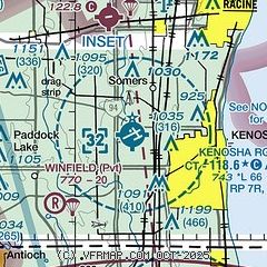
| Sectional chart |
|---|
|
CAUTION: Diagram may not be current
 Download PDF
of official airport diagram from the FAA
| Airport distance calculator |
|---|
|
|
| Sunrise and sunset |
|---|
|
Times for 05-Feb-2026
| | Local
(UTC-6) | | Zulu
(UTC) |
|---|
| Morning civil twilight | | 06:33 | | 12:33 |
| Sunrise | | 07:02 | | 13:02 |
| Sunset | | 17:09 | | 23:09 |
| Evening civil twilight | | 17:39 | | 23:39 |
|
| Current date and time |
|---|
| Zulu (UTC) | 06-Feb-2026 04:08:02 |
|---|
| Local (UTC-6) | 05-Feb-2026 22:08:02 |
|---|
|
| METAR |
|---|
| KENW | 060253Z 27005KT 10SM OVC020 M01/M04 A2980
|
KUGN
11nm S | 060351Z AUTO 23006KT 10SM OVC018 M02/M04 A2976 RMK AO2 SLP094 T10171044
|
KRAC
11nm NE | 060401Z AUTO 23005KT 10SM FEW020 BKN120 M01/M04 A2975 RMK AO2 T10061039
|
KBUU
17nm W | 060355Z AUTO 24005KT 10SM OVC016 A2974 RMK AO2 PWINO
|
|
| TAF |
|---|
| KENW | 052217Z 0522/0618 23011KT P6SM OVC025 FM060200 22008KT P6SM OVC015 FM061000 27007KT 5SM -SN SCT009 OVC012 PROB30 0610/0613 3SM -SN OVC008 FM061400 32011G22KT P6SM OVC015
|
|
| NOTAMs |
|---|
NOTAMs are issued by the DoD/FAA and will open in a separate window not controlled by AirNav.
|
|


