FAA INFORMATION EFFECTIVE 20 MARCH 2025
Location
| FAA Identifier: | FHB |
| Lat/Long: | 30-36-42.6000N 081-27-40.3000W
30-36.710000N 081-27.671667W
30.6118333,-81.4611944
(estimated) |
| Elevation: | 15.7 ft. / 4.8 m (surveyed) |
| Variation: | 05W (2000) |
| From city: | 3 miles S of FERNANDINA BEACH, FL |
| Time zone: | UTC -4 (UTC -5 during Standard Time) |
| Zip code: | 32034 |
Airport Operations
| Airport use: | Open to the public |
| Activation date: | 10/1944 |
| Control tower: | no |
| ARTCC: | JACKSONVILLE CENTER |
| FSS: | GAINESVILLE FLIGHT SERVICE STATION |
| NOTAMs facility: | GNV (NOTAM-D service available) |
| Attendance: | 0700-1900 |
| Wind indicator: | lighted |
| Segmented circle: | yes |
| Lights: | ACTVT REIL RWY 04 & 13; PAPI RWY 04, 09, 13, 22, 27; MIRL RWY 04/22, 09/27 & 13/31 - CTAF. |
| Beacon: | white-green (lighted land airport)
Operates sunset to sunrise. |
Airport Communications
| CTAF/UNICOM: | 122.7 |
| WX AWOS-3: | 118.075 (904-277-7323) |
| JACKSONVILLE APPROACH: | 127.0 |
| JACKSONVILLE DEPARTURE: | 127.0 |
| WX ASOS at JAX (14 nm SW): | 125.85 (904-741-4304) |
| WX ASOS at CRG (17 nm S): | 125.4 (904-646-4670) |
Nearby radio navigation aids
| VOR radial/distance | | VOR name | | Freq | | Var |
|---|
| CRGr012/16.6 | | CRAIG VORTAC | | 114.50 | | 03W |
| SSIr186/26.3 | | BRUNSWICK VORTAC | | 109.80 | | 04W |
| SGJr356/39.9 | | ST AUGUSTINE VOR/DME | | 109.40 | | 06W |
Airport Services
| Fuel available: | 100LL JET-A |
| Parking: | hangars and tiedowns |
| Airframe service: | MAJOR |
| Powerplant service: | MAJOR |
| Bottled oxygen: | NONE |
| Bulk oxygen: | NONE |
Runway Information
Runway 4/22
| Dimensions: | 5301 x 100 ft. / 1616 x 30 m |
| Surface: | asphalt/grooved, in excellent condition |
| Weight bearing capacity: | | PCN 24 /F/B/W/T | | Single wheel: | 66.0 | | Double wheel: | 94.0 |
|
| Runway edge lights: | medium intensity |
| RUNWAY 4 | | RUNWAY 22 |
| Latitude: | 30-36.287650N | | 30-36.998885N |
| Longitude: | 081-27.991465W | | 081-27.403188W |
| Elevation: | 12.4 ft. | | 14.2 ft. |
| Traffic pattern: | left | | left |
| Runway heading: | 041 magnetic, 036 true | | 221 magnetic, 216 true |
| Displaced threshold: | no | | 440 ft. |
| Markings: | nonprecision, in good condition | | nonprecision, in good condition |
| Visual slope indicator: | 4-light PAPI on left (3.00 degrees glide path) | | 4-light PAPI on left (3.00 degrees glide path) |
| Runway end identifier lights: | yes | | |
| Touchdown point: | yes, no lights | | yes, no lights |
| Obstructions: | 35 ft. trees, 1445 ft. from runway, 70 ft. right of centerline, 35:1 slope to clear | | 45 ft. trees, 1120 ft. from runway, 25 ft. left of centerline, 20:1 slope to clear
RWY 22, APCH RATIO 35:1 TO DSPLCD THLD. |
Runway 13/31
| Dimensions: | 5152 x 100 ft. / 1570 x 30 m |
| Surface: | asphalt, in fair condition |
| Weight bearing capacity: | | PCN 5 /F/B/Y/T | | Single wheel: | 18.0 |
|
| Runway edge lights: | medium intensity |
| RUNWAY 13 | | RUNWAY 31 |
| Latitude: | 30-36.870498N | | 30-36.375875N |
| Longitude: | 081-28.103227W | | 081-27.304138W |
| Elevation: | 12.2 ft. | | 14.4 ft. |
| Traffic pattern: | left | | left |
| Runway heading: | 131 magnetic, 126 true | | 311 magnetic, 306 true |
| Displaced threshold: | no | | 793 ft. |
| Markings: | nonprecision, in fair condition | | nonprecision, in fair condition |
| Visual slope indicator: | 2-light PAPI on left (3.00 degrees glide path) | | |
| Runway end identifier lights: | yes | | |
| Touchdown point: | yes, no lights | | yes, no lights |
| Obstructions: | 44 ft. tree, 2045 ft. from runway, 50 ft. right of centerline, 42:1 slope to clear | | 56 ft. trees, 775 ft. from runway, 10:1 slope to clear
RWY 31 APCH RATIO 28:1 AT DSPLCD THLD. |
Runway 9/27
| Dimensions: | 5000 x 100 ft. / 1524 x 30 m |
| Surface: | concrete/wired/combed, in good condition |
| Weight bearing capacity: | | PCN 29 /R/B/W/T | | Single wheel: | 80.0 | | Double wheel: | 102.0 |
|
| Runway edge lights: | medium intensity |
| RUNWAY 9 | | RUNWAY 27 |
| Latitude: | 30-36.800892N | | 30-36.935828N |
| Longitude: | 081-28.079568W | | 081-27.138855W |
| Elevation: | 12.3 ft. | | 13.3 ft. |
| Traffic pattern: | left | | left |
| Runway heading: | 086 magnetic, 081 true | | 266 magnetic, 261 true |
| Displaced threshold: | no | | 699 ft. |
| Markings: | nonprecision, in fair condition | | nonprecision, in fair condition |
| Visual slope indicator: | 4-light PAPI on left (3.00 degrees glide path) | | 4-light PAPI on left (3.00 degrees glide path) |
| Touchdown point: | yes, no lights | | yes, no lights |
| Obstructions: | 49 ft. tree, 1210 ft. from runway, 210 ft. left of centerline, 21:1 slope to clear | | 15 ft. road, 370 ft. from runway, 250 ft. left of centerline, 11:1 slope to clear
RWY 27 APCH RATIO 25:1 AT DSPLCD THLD. |
Airport Ownership and Management from official FAA records
| Ownership: | Publicly-owned |
| Owner: | CITY OF FERNANDINA BEACH
204 ASH ST
FERNANDINA BEACH, FL 32034
Phone 904-310-3101 |
| Manager: | SAM CARVER
700 AIRPORT ROAD
FERNANDINA BEACH, FL 32034
Phone 904-310-3436 |
Additional Remarks
| - | NOISE ABATEMENT PROC IN EFCT - 904-310-3436. |
| - | PRCHT OPS DLY NW CORNER OF FLD. AVOID OVERFLYING ARPT DURG PRCHT OPS. |
| - | DRG CALM WINDS USE RWY 22. |
| - | RWY 13/31 SUBJ FLOODING DURG HVY RAIN. |
| - | BIRDS ON & INVOF ARPT. |
| - | CAUTION: ACFT ON RWY 31 NOT VSBL TO ACFT ON RWY 22 OR RWY 27. |
| - | FOR CD CTC JACKSONVILLE APCH AT 904-741-0284. |
Instrument Procedures
NOTE: All procedures below are presented as PDF files. If you need a reader for these files, you should download the free Adobe Reader.NOT FOR NAVIGATION. Please procure official charts for flight.
FAA instrument procedures published for use from 20 March 2025 at 0901Z to 17 April 2025 at 0900z.
IAPs - Instrument Approach Procedures |
|---|
| RNAV (GPS) RWY 04 | |
download (219KB) |
| RNAV (GPS) RWY 13 | |
download (276KB) |
| RNAV (GPS) RWY 22 | |
download (275KB) |
| NOTE: Special Alternate Minimums apply | |
download (127KB) |
| NOTE: Special Take-Off Minimums/Departure Procedures apply | |
download (166KB) |
Other nearby airports with instrument procedures:
KNRB - Mayport Naval Station (Adm David L. McDonald Field) (13 nm S)
KJAX - Jacksonville International Airport (14 nm SW)
KCRG - Jacksonville Executive Airport at Craig (17 nm S)
KNIP - Jacksonville Naval Air Station (Towers Field) (25 nm SW)
KHEG - Herlong Recreational Airport (27 nm SW)
|
|

Road maps at:
MapQuest
Bing
Google
| Aerial photo |
|---|
WARNING: Photo may not be current or correct
 Photo by Dave Fogarty
DPE/ATP/CFI/A&P-IA/FAAST
Photo taken 30-Jan-2019
looking west from 9,000’ MSL
Do you have a better or more recent aerial photo of Fernandina Beach Municipal Airport that you would like to share? If so, please send us your photo.
|
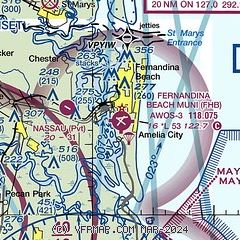
| Sectional chart |
|---|
|
CAUTION: Diagram may not be current
 Download PDF
of official airport diagram from the FAA
| Airport distance calculator |
|---|
|
|
| Sunrise and sunset |
|---|
|
Times for 12-Apr-2025
| | Local
(UTC-4) | | Zulu
(UTC) |
|---|
| Morning civil twilight | | 06:38 | | 10:38 |
| Sunrise | | 07:03 | | 11:03 |
| Sunset | | 19:51 | | 23:51 |
| Evening civil twilight | | 20:15 | | 00:15 |
|
| Current date and time |
|---|
| Zulu (UTC) | 13-Apr-2025 01:30:40 |
|---|
| Local (UTC-4) | 12-Apr-2025 21:30:40 |
|---|
|
| METAR |
|---|
| KFHB | 130115Z AUTO 12003KT 10SM CLR 16/11 A3002 RMK AO2
|
KJAX
13nm SW | 130056Z 08004KT 10SM SCT080 16/12 A3000 RMK AO2 SLP158 T01610117 $
|
KNRB
14nm S | 130052Z 10006KT 10SM FEW070 19/12 A3000 RMK AO2 SLP159 T01940117
|
KCRG
17nm S | 130053Z AUTO 00000KT 10SM SCT080 15/12 A3001 RMK AO2 SLP161 T01500122
|
|
| TAF |
|---|
KJAX
13nm SW | 122109Z 1221/1318 33011KT P6SM SCT060 FM122300 10008KT P6SM FEW050 FM130200 00000KT P6SM SKC
|
KNRB
14nm S | 1223/1323 VRB06KT 9999 BKN070 QNH2994INS FM130200 VRB06KT 9999 FEW080 QNH2995INS FM131800 08009KT 9999 SKC QNH2998INS AUTOMATED SENSOR METWATCH 1302 TIL 1315 TX21/1318Z TN12/1312Z FN00287
|
KCRG
17nm S | 122108Z 1221/1318 10008KT P6SM FEW050 FM130400 00000KT P6SM SKC
|
|
| NOTAMs |
|---|
NOTAMs are issued by the DoD/FAA and will open in a separate window not controlled by AirNav.
|
|


