FAA INFORMATION EFFECTIVE 27 NOVEMBER 2025
Location
| FAA Identifier: | JAX |
| Lat/Long: | 30-29-38.5640N 081-41-16.2480W
30-29.642733N 081-41.270800W
30.4940456,-81.6878467
(estimated) |
| Elevation: | 29.6 ft. / 9.0 m (surveyed) |
| Variation: | 06W (2010) |
| From city: | 9 miles N of JACKSONVILLE, FL |
| Time zone: | UTC -5 (UTC -4 during Daylight Saving Time) |
| Zip code: | 32218 |
Airport Operations
| Airport use: | Open to the public |
| Activation date: | 11/1968 |
| Control tower: | yes |
| ARTCC: | JACKSONVILLE CENTER |
| FSS: | GAINESVILLE FLIGHT SERVICE STATION |
| NOTAMs facility: | JAX (NOTAM-D service available) |
| Attendance: | CONTINUOUS |
| Wind indicator: | lighted |
| Segmented circle: | yes |
| Lights: | SS-SR |
| Beacon: | white-green (lighted land airport)
Operates sunset to sunrise. |
| Fire and rescue: | ARFF index D |
| Airline operations: | PPR 24 HRS FOR UNSKED ACR OPNS WITH MORE THAN 30 PSGR SEATS CALL AMGR 904-741-2020. |
| International operations: | customs landing rights airport |
Airport Communications
| UNICOM: | 122.95 |
| WX ASOS: | 125.85 (904-549-9655) |
| JACKSONVILLE TOWER GROUND: | 121.9 348.6 |
| JACKSONVILLE TOWER TOWER: | 118.3 317.7 |
| JACKSONVILLE APPROACH: | 119.0 121.3 ;ABV 6000 FT 124.9 ;091-180 5000 FT & BLW 127.0 ;270-090 127.775 ;181-269 132.775 ;091-180 ABV 5000 FT 269.9 284.6 ;091-180 ABV 5000 FT 292.15 ;270-090 308.4 ;091-180 5000 FT & BLW 377.075 ;181-269 119.0 ;270-090 269.9 ;270-090 |
| JACKSONVILLE DEPARTURE: | 119.0 121.3 ;ABV 6000 FT 124.9 ;091-180 5000 FT & BLW 127.0 ;270-090 127.775 ;181-269 132.775 ;091-180 ABV 5000 FT 269.9 284.6 ;091-180 ABV 5000 FT 292.15 ;270-090 308.4 ;091-180 5000 FT & BLW 377.075 ;181-269 119.0 ;270-090 269.9 ;270-090 |
| CLEARANCE DELIVERY: | 119.5 290.275 348.6 |
| ALCRN STAR: | 127.0 269.9 |
| ANG OPS: | 273.9 381.0 |
| ARNEY DP: | 127.0 292.15 |
| CLASS C: | 124.9 ;091-180 5000 FT & BLW 127.0 ;270-090 127.775 ;181-269 132.775 ;091-180 ABV 5000 FT 284.6 ;091-180 ABV 5000 FT 292.15 ;270-090 308.4 ;091-180 5000 FT & BLW 377.075 ;181-269 |
| CLASS C/S: | 119.0 ;270-090 269.9 ;270-090 |
| CROSB DP: | 127.0 292.15 |
| D-ATIS: | 125.85 |
| EMERG: | 121.5 243.0 |
| EXBOX DP: | 124.9 308.4 |
| HOTAR STAR: | 119.0 ;270-090 124.9 ;091-180 127.0 ;270-090 127.775 ;181-269 269.9 ;270-090 292.15 ;270-090 308.4 ;091-180 377.075 ;181-269 |
| IC: | 119.0 269.9 |
| JACKSONVILLE DP: | 127.0 292.15 |
| JETIN DP: | 127.0 292.15 |
| LUNNI STAR: | 119.0 ;270-090 124.9 ;091-180 127.0 ;270-090 127.775 ;181-269 269.9 ;270-090 292.15 ;270-090 308.4 ;091-180 377.075 ;181-269 |
| MARQO STAR: | 119.0 ;270-090 124.9 ;091-180 127.0 ;270-090 127.775 ;181-269 269.9 ;270-090 292.15 ;270-090 308.4 ;091-180 377.075 ;181-269 |
| OHDEA STAR: | 119.0 ;270-090 124.9 ;091-180 127.0 ;270-090 127.775 ;181-269 269.9 ;270-090 292.15 ;270-090 308.4 ;091-180 377.075 ;181-269 |
| POGIE STAR: | 127.775 379.9 |
| QUBEN STAR: | 119.0 ;270-090 124.9 ;091-180 127.0 ;270-090 127.775 ;181-269 269.9 ;270-090 292.15 ;270-090 308.4 ;091-180 377.075 ;181-269 |
| SAWGY DP: | 124.9 308.4 |
| TEBOW STAR: | 119.0 ;270-090 124.9 ;091-180 127.0 ;270-090 127.775 ;181-269 269.9 ;270-090 292.15 ;270-090 308.4 ;091-180 377.075 ;181-269 |
| WX ASOS at CRG (13 nm SE): | 125.4 (904-646-4670) |
| WX AWOS-3 at FHB (14 nm NE): | 118.075 (904-277-7323) |
| WX AWOS-3 at HEG (14 nm SW): | 119.275 (904-695-0334) |
| WX AWOS-3 at NIP (16 nm S): | 119.275 |
| WX AWOS-3 at VQQ (19 nm SW): | 125.275 (904-778-6934) |
- SAID IN USE. OPERATE TRANSPONDERS WITH ALTITUDE REPORTING MODE AND ADS-B (IF EQUIPPED) ENABLED ON ALL AIRPORT SURFACES.
Nearby radio navigation aids
| VOR radial/distance | | VOR name | | Freq | | Var |
|---|
| CRGr318/13.1 | | CRAIG VORTAC | | 114.50 | | 03W |
| SSIr204/35.6 | | BRUNSWICK VORTAC | | 109.80 | | 04W |
| SGJr336/37.2 | | ST AUGUSTINE VOR/DME | | 109.40 | | 06W |
| NDB name | | Hdg/Dist | | Freq | | Var | | ID |
|---|
| DINNS | | 080/6.1 | | 344 | | 06W | | JA | .--- .- |
| REYNOLDS | | 004/31.7 | | 338 | | 07W | | RYD | .-. -.-- -.. |
Airport Services
| Fuel available: | 100LL JET-A |
| Parking: | hangars and tiedowns |
| Airframe service: | MAJOR |
| Powerplant service: | MINOR |
Runway Information
Runway 8/26
| Dimensions: | 10000 x 150 ft. / 3048 x 46 m |
| Surface: | concrete/grooved, in good condition |
| Weight bearing capacity: | | Single wheel: | 120.0 | | Double wheel: | 250.0 | | Double tandem: | 550.0 | | Dual double tandem: | 1120.0 |
|
| Runway edge lights: | high intensity |
| RUNWAY 8 | | RUNWAY 26 |
| Latitude: | 30-29.772988N | | 30-30.322337N |
| Longitude: | 081-41.997905W | | 081-40.201618W |
| Elevation: | 29.4 ft. | | 26.4 ft. |
| Traffic pattern: | left | | left |
| Runway heading: | 077 magnetic, 071 true | | 257 magnetic, 251 true |
| Markings: | precision, in fair condition | | precision, in fair condition |
| Visual slope indicator: | 4-light PAPI on left (3.00 degrees glide path) | | 4-light PAPI on right (3.00 degrees glide path) |
| RVR equipment: | touchdown, midfield, rollout | | touchdown, midfield, rollout |
| Approach lights: | ALSF2: standard 2,400 foot high intensity approach lighting system with centerline sequenced flashers (category II or III) | | MALSR: 1,400 foot medium intensity approach lighting system with runway alignment indicator lights |
| Runway end identifier lights: | | | no |
| Centerline lights: | yes | | yes |
| Touchdown point: | yes, lighted | | yes, lighted |
| Instrument approach: | ILS | | ILS |
| Obstructions: | 63 ft. trees, 3350 ft. from runway, 350 ft. right of centerline | | none |
Runway 14/32
| Dimensions: | 7701 x 150 ft. / 2347 x 46 m |
| Surface: | concrete/grooved, in good condition |
| Weight bearing capacity: | | Single wheel: | 120.0 | | Double wheel: | 250.0 | | Double tandem: | 550.0 | | Dual double tandem: | 1120.0 |
|
| Runway edge lights: | high intensity |
| RUNWAY 14 | | RUNWAY 32 |
| Latitude: | 30-29.529698N | | 30-28.703977N |
| Longitude: | 081-42.050210W | | 081-40.935505W |
| Elevation: | 26.9 ft. | | 24.0 ft. |
| Traffic pattern: | left | | left |
| Runway heading: | 137 magnetic, 131 true | | 317 magnetic, 311 true |
| Markings: | precision, in good condition | | precision, in good condition |
| Visual slope indicator: | 4-light PAPI on left (3.00 degrees glide path) | | 4-light PAPI on left (3.00 degrees glide path) |
| Approach lights: | MALSR: 1,400 foot medium intensity approach lighting system with runway alignment indicator lights | | |
| Runway end identifier lights: | | | yes |
| Centerline lights: | yes | | yes |
| Touchdown point: | yes, lighted | | yes, no lights |
| Instrument approach: | ILS/DME | | |
| Obstructions: | 50 ft. trees, 2735 ft. from runway, 235 ft. right of centerline | | 68 ft. trees, 3290 ft. from runway, 45:1 slope to clear |
Airport Ownership and Management from official FAA records
| Ownership: | Publicly-owned |
| Owner: | JACKSONVILLE INTL AIRPORT
14201 PECAN PARK ROAD
JACKSONVILLE, FL 32218
Phone 904-741-2000 |
| Manager: | MR. TERRY DLUGOS
14201 PECAN PARK ROAD
JACKSONVILLE, FL 32218
Phone (904) 741-3866 |
Additional Remarks
| A39-14/32 | PCR VALUE: 1380/R/B/W/T |
| A39-08/26 | PCR VALUE: 970/R/A/W/T |
| E60-08 | BAK-14 BAK-12B(B) (1537 FT). |
| E60-26 | BAK-14 BAK-12B-(B) (1612 FT) |
| - | BIRD ACTIVITY INVOF ARPT, WILDLIFE PRESENTLY ON AIRFIELD. |
| - | NON-LOAD BEARING ASPHALT ON WEST AIR CARRIER RAMP BTWN OUTER HIGH MAST LIGHTS AND TERMINAL. AIRCRAFT RQRD TO MAINTAIN TAXI OPS OVER CTRLN ON THE AIR CARRIER RAMP. |
| - | PPR FOR HIGH POWER JET ENGINE RUN UPS CTC APT OPS AT 904-741-2020. |
| - | MILITARY: ANG: OPR DAYS VARY. BASE OPS 1130-2100Z++. OFFL BUS ONLY. PPR FOR ALL TRAN AFCT (CALL FANG OPS) DSN 641-7122/40/25,C 904-741-7122/40/25. PPR NEEDED TO PROCD ON TWY M1, M2, M3 FANG MAIN RAMP AND ALERT RAMP. PPR NO RESTRD TO ONLY 1 HR EARLIER OR LTR THAN APVL TIME, BFR/AFT THOSE TIMES THE NO IS NOT VALID. TRAN SVCS UNAVBL. FOR CURRENT BWC CTC SOF (FANG OPS) 251.25. BASH PHASE II 1 NOV THRU 31 MAR FOR MIGRATORY BIRD ACT. FOR MORE DTLD INFO SEE AP/1. |
| - | ARPT CLSD TO ACFT WINGSPAN MORE THAN 171 FT EXC 6 HR PPR 904-741-2020. |
| - | BAK-14 CABLE RAISED FOR TAILHOOK ENGAGEMENT BY TWR ON PILOT REQ ONLY, 1537 FT FM AER 08 AND 1612 FT FM AER 26. |
| - | ARPT CLSD TO INTL GEN AVIATION ARR EXE 6HR PPR ARPT OPS AT 904-741-2020 & CTC U. S. CUSTOMS & SERVICING FBO FOR PROCESSING & INSTRUCTIONS. |
| - | RADIO CONTROLLED ACFT ACTIVITY 3.5 NM 'NNW' OF ARPT. |
| - | SMALL PORTION OF TERMINAL RAMP NOT VISIBLE FM TWR. TWR UNABLE TO DETERMINE IF RAMP IS CLEAR. |
Instrument Procedures
NOTE: All procedures below are presented as PDF files. If you need a reader for these files, you should download the free Adobe Reader.NOT FOR NAVIGATION. Please procure official charts for flight.
FAA instrument procedures published for use from 27 November 2025 at 0901Z to 25 December 2025 at 0900Z.
STARs - Standard Terminal Arrivals |
|---|
| ALCRN ONE (RNAV) | |
download (154KB) |
| HOTAR ONE (RNAV) **CHANGED** | |
download (225KB) |
| LUNNI TWO (RNAV) | |
download (127KB) |
| MARQO THREE (RNAV) | |
download (171KB) |
| OHDEA TWO (RNAV) | |
download (134KB) |
| POGIE TWO | |
download (169KB) |
| QUBEN TWO (RNAV) | |
download (163KB) |
| TEBOW TWO (RNAV) | |
download (133KB) |
IAPs - Instrument Approach Procedures |
|---|
| HI-ILS Z OR LOC Z RWY 08 | |
download (182KB) |
| HI-ILS Z OR LOC Z RWY 14 | |
download (188KB) |
| HI-ILS Z OR LOC Z RWY 26 | |
download (193KB) |
| ILS Y OR LOC Y RWY 08 **CHANGED** | |
download (282KB) |
| ILS Y OR LOC Y RWY 14 **CHANGED** | |
download (290KB) |
| ILS Y OR LOC Y RWY 26 **CHANGED** | |
download (309KB) |
| ILS Y RWY 08 (SA CAT I) **CHANGED** | |
download (256KB) |
| ILS Y RWY 08 (CAT II - III) **CHANGED** | |
download (254KB) |
| RNAV (RNP) Y RWY 08 **CHANGED** | |
download (245KB) |
| RNAV (RNP) Y RWY 14 **CHANGED** | |
download (230KB) |
| RNAV (RNP) Y RWY 26 **CHANGED** | |
download (252KB) |
| RNAV (RNP) Y RWY 32 **CHANGED** | |
download (234KB) |
| RNAV (GPS) Z RWY 08 **CHANGED** | |
download (276KB) |
| RNAV (GPS) Z RWY 14 **CHANGED** | |
download (297KB) |
| RNAV (GPS) Z RWY 26 **CHANGED** | |
download (284KB) |
| RNAV (GPS) Z RWY 32 **CHANGED** | |
download (275KB) |
| VOR/DME RWY 32 **CHANGED** | |
download (265KB) |
| HI-TACAN RWY 14 | |
download (169KB) |
| NOTE: Special Alternate Minimums apply | |
download (147KB) |
Departure Procedures |
|---|
| BRSTL ONE (RNAV) | |
download (158KB) |
| CROSB TWO (RNAV) | |
download (230KB) |
| EXBOX TWO (RNAV) | |
download (226KB) |
| JACKSONVILLE SEVEN | |
download (181KB) |
| JETIN TWO (RNAV) | |
download (240KB) |
| SAWGY THREE | |
download (143KB) |
| NOTE: Special Take-Off Minimums/Departure Procedures apply | |
download (440KB) |
Other nearby airports with instrument procedures:
KCRG - Jacksonville Executive Airport at Craig (13 nm SE)
KFHB - Fernandina Beach Municipal Airport (14 nm NE)
KHEG - Herlong Recreational Airport (14 nm SW)
KNRB - Mayport Naval Station (Adm David L. McDonald Field) (15 nm SE)
KNIP - Jacksonville Naval Air Station (Towers Field) (16 nm S)
KVQQ - Cecil Airport (19 nm SW)
|
|

Road maps at:
MapQuest
Bing
Google
| Aerial photo |
|---|
WARNING: Photo may not be current or correct
 Photo courtesy of Joe Ramirez at www.airhawkone.com
Photo taken 13-Sep-2008
Photo courtesy of Joe Ramirez at www.airhawkone.com
Photo taken 13-Sep-2008
Do you have a better or more recent aerial photo of Jacksonville International Airport that you would like to share? If so, please send us your photo.
|
| Sectional chart |
|---|
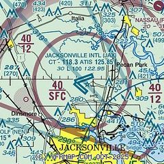
|
CAUTION: Diagram may not be current
 Download PDF
of official airport diagram from the FAA
| Airport distance calculator |
|---|
|
|
| Sunrise and sunset |
|---|
|
Times for 12-Dec-2025
| | Local
(UTC-5) | | Zulu
(UTC) |
|---|
| Morning civil twilight | | 06:49 | | 11:49 |
| Sunrise | | 07:15 | | 12:15 |
| Sunset | | 17:26 | | 22:26 |
| Evening civil twilight | | 17:52 | | 22:52 |
|
| Current date and time |
|---|
| Zulu (UTC) | 12-Dec-2025 22:27:27 |
|---|
| Local (UTC-5) | 12-Dec-2025 17:27:27 |
|---|
|
| METAR |
|---|
| KJAX | 122156Z 17006KT 10SM FEW250 18/03 A3009 RMK AO2 SLP190 T01780033
|
KNEN
13nm SW | 122153Z AUTO 15003KT 10SM CLR 18/04 A3010 RMK AO2 SLP260 T01780044 PWINO $
|
KCRG
13nm SE | 122153Z 15006KT 10SM CLR 16/06 A3010 RMK AO2 SLP194 T01610061
|
KHEG
14nm SW | 122215Z AUTO 14005KT 10SM CLR 17/05 A3012 RMK AO2 TSNO
|
KNRB
16nm SE | 122152Z 16006KT 10SM FEW250 16/06 A3011 RMK AO2 SLP194 T01560056 $
|
KNIP
17nm S | 122153Z 17005KT 10SM CLR 18/03 A3011 RMK AO2 SLP190 T01830033 $
|
KVQQ
19nm SW | 122150Z VRB04KT 10SM CLR 20/02 A3010
|
|
| TAF |
|---|
| KJAX | 121720Z 1218/1318 VRB04KT P6SM SKC FM130900 00000KT 4SM BR SKC FM131400 VRB04KT P6SM SCT250
|
KCRG
13nm SE | 121720Z 1218/1318 VRB04KT P6SM SKC FM130900 00000KT 6SM BR SKC FM131400 VRB04KT P6SM SCT250
|
KNRB
16nm SE | 1215/1315 VRB05KT 9999 FEW250 QNH3010INS FM130300 29005KT 9999 FEW250 QNH3015INS LAST NO AMDS AFT 1223 NEXT 1415 AUTOMATED SENSOR METWATCH 1223 TIL 1416 TX19/1218Z TN08/1312Z FN20021
|
KNIP
17nm S | 1215/1315 VRB04KT 9999 FEW250 QNH3011INS FM121900 22005KT 9999 FEW250 QNH3010INS FM130300 25004KT 9999 FEW250 QNH3016INS FM130900 VRB04KT 9999 FEW025 SCT250 QNH3017INS TX19/1220Z TN08/1312Z FN20089
|
KVQQ
19nm SW | 121720Z 1218/1318 VRB04KT P6SM SKC FM130600 00000KT 3SM BR SKC TEMPO 1308/1312 1/2SM FG BKN002 FM131400 VRB04KT P6SM SCT250
|
|
| NOTAMs |
|---|
NOTAMs are issued by the DoD/FAA and will open in a separate window not controlled by AirNav.
|
|


