FAA INFORMATION EFFECTIVE 20 MARCH 2025
Location
| FAA Identifier: | GHG |
| Lat/Long: | 42-05-50.9958N 070-40-22.8715W
42-05.849930N 070-40.381192W
42.0974988,-70.6730199
(estimated) |
| Elevation: | 8.9 ft. / 2.7 m (surveyed) |
| Variation: | 16W (1990) |
| From city: | 2 miles E of MARSHFIELD, MA |
| Time zone: | UTC -4 (UTC -5 during Standard Time) |
| Zip code: | 02050 |
Airport Operations
| Airport use: | Open to the public |
| Activation date: | 03/1948 |
| Control tower: | no |
| ARTCC: | BOSTON CENTER |
| FSS: | BRIDGEPORT FLIGHT SERVICE STATION |
| NOTAMs facility: | BDR (NOTAM-D service available) |
| Attendance: | 0800-1900 |
| Wind indicator: | yes |
| Segmented circle: | yes |
| Lights: | ACTVT PAPI RWY 6 & 24 - CTAF. |
| Beacon: | white-green (lighted land airport)
Operates sunset to sunrise. |
Airport Communications
| CTAF/UNICOM: | 122.8 |
| WX AWOS-3: | 120.0 (781-837-0555) |
| BOSTON APPROACH: | 124.1 |
| BOSTON DEPARTURE: | 124.1 |
| WOONS STAR: | 120.6 |
| WX ASOS at PYM (12 nm S): | 135.625 (508-732-8358) |
- CLNC DEL THRU BRIDGEPORT RADIO (BDR) 1-866-293-5149.
Nearby radio navigation aids
| VOR radial/distance | | VOR name | | Freq | | Var |
|---|
| BOSr154/21.0 | | BOSTON VOR/DME | | 112.70 | | 16W |
| LFVr296/28.7 | | MARCONI VOR/DME | | 114.70 | | 16W |
| NDB name | | Hdg/Dist | | Freq | | Var | | ID |
|---|
| PROVINCETOWN | | 291/20.1 | | 389 | | 16W | | PVC | .--. ...- -.-. |
| NAUSET | | 324/39.1 | | 279 | | 16W | | CQX | -.-. --.- -..- |
Airport Services
| Fuel available: | 100LL JET-A JET-A+ |
| Parking: | hangars and tiedowns |
| Airframe service: | MAJOR |
| Powerplant service: | MAJOR |
| Bottled oxygen: | HIGH |
| Bulk oxygen: | HIGH |
Runway Information
Runway 6/24
| Dimensions: | 3900 x 100 ft. / 1189 x 30 m |
| Surface: | asphalt/grooved, in excellent condition |
| Weight bearing capacity: | | PCN 190/F/B/X/T | | Single wheel: | 12.5 | | Double wheel: | 38.8 |
|
| Runway edge lights: | medium intensity |
| RUNWAY 6 | | RUNWAY 24 |
| Latitude: | 42-05.627232N | | 42-06.072628N |
| Longitude: | 070-40.691738W | | 070-40.070645W |
| Elevation: | 5.2 ft. | | 3.5 ft. |
| Traffic pattern: | left | | left |
| Runway heading: | 062 magnetic, 046 true | | 242 magnetic, 226 true |
| Displaced threshold: | 300 ft. | | 300 ft. |
| Declared distances: | TORA:3900 TODA:3900 ASDA:3600 LDA:3300 | | TORA:3900 TODA:3900 ASDA:3600 LDA:3300 |
| Markings: | nonprecision, in good condition | | nonprecision, in good condition |
| Visual slope indicator: | 4-light PAPI on right (3.00 degrees glide path) | | 4-light PAPI on right (3.00 degrees glide path) |
| Runway end identifier lights: | yes | | yes |
| Touchdown point: | yes, no lights | | yes, no lights |
| Obstructions: | 80 ft. trees, 1396 ft. from runway, 186 ft. right of centerline, 14:1 slope to clear | | 49 ft. trees, 960 ft. from runway, 204 ft. left of centerline, 15:1 slope to clear |
Airport Ownership and Management from official FAA records
| Ownership: | Publicly-owned |
| Owner: | TOWN OF MARSHFIELD
870 MORAINE ST
MARSHFIELD, MA 02050
Phone 781-536-2500 |
| Manager: | JASON TIBBETTS
93 OLD COLONY LANE
MARSHFIELD, MA 02050
Phone 781-834-4928 |
Additional Remarks
| - | BIRDS, DEER & WILDLIFE ON & INVOF ARPT. |
| - | ALL ENG RUNUPS AT MIDFIELD RAMP. |
| - | VOLUNTARY NOISE ABATEMENT PROCS IN EFCT, NO TGLS BTN 2100 & 0730 LCL. |
| - | FLT TRNG ACTVY. |
| - | AFT HRS SVC BY REQ. |
| - | SFC CONDS UNMNT & SNOW REMOVAL NA APRXLY 1930-0900. |
| - | FOR CD CTC BOSTON APCH AT 603-594-5554. |
Instrument Procedures
NOTE: All procedures below are presented as PDF files. If you need a reader for these files, you should download the free Adobe Reader.NOT FOR NAVIGATION. Please procure official charts for flight.
FAA instrument procedures published for use from 20 March 2025 at 0901Z to 17 April 2025 at 0900z.
STARs - Standard Terminal Arrivals |
|---|
| WOONS TWO | |
download (156KB) |
IAPs - Instrument Approach Procedures |
|---|
| RNAV (GPS) RWY 06 | |
download (217KB) |
| RNAV (GPS) RWY 24 | |
download (231KB) |
| NOTE: Special Alternate Minimums apply | |
download (129KB) |
| NOTE: Special Take-Off Minimums/Departure Procedures apply | |
download (484KB) |
Other nearby airports with instrument procedures:
KPYM - Plymouth Municipal Airport (12 nm S)
KPVC - Provincetown Municipal Airport (20 nm E)
KTAN - Taunton Municipal Airport/King Field (20 nm SW)
KBOS - General Edward Lawrence Logan International Airport (22 nm NW)
KOWD - Norwood Memorial Airport (23 nm W)
|
|

Road maps at:
MapQuest
Bing
Google
| Aerial photo |
|---|
WARNING: Photo may not be current or correct
 Taken in 2015
looking east.
Taken in 2015
looking east.
Do you have a better or more recent aerial photo of Marshfield Municipal Airport - George Harlow Field that you would like to share? If so, please send us your photo.
|
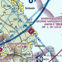
| Sectional chart |
|---|
|
CAUTION: Diagram may not be current

| Airport distance calculator |
|---|
|
|
| Sunrise and sunset |
|---|
|
Times for 16-Apr-2025
| | Local
(UTC-4) | | Zulu
(UTC) |
|---|
| Morning civil twilight | | 05:32 | | 09:32 |
| Sunrise | | 06:02 | | 10:02 |
| Sunset | | 19:24 | | 23:24 |
| Evening civil twilight | | 19:53 | | 23:53 |
|
| Current date and time |
|---|
| Zulu (UTC) | 16-Apr-2025 06:42:53 |
|---|
| Local (UTC-4) | 16-Apr-2025 02:42:53 |
|---|
|
| METAR |
|---|
| KGHG | 160615Z AUTO VRB06G12KT 10SM SCT048 07/01 A2947 RMK AO2
|
KPYM
11nm S | 160552Z AUTO 27011KT 10SM FEW075 08/01 A2947 RMK AO2 SLP982 60000 T00830011 10100 20072 51011
|
KTAN
20nm SW | 160552Z AUTO VRB04KT 10SM FEW050 07/01 A2949 RMK AO2 SLP985 60000 T00720011 10094 20072 51012
|
|
| TAF |
|---|
KBOS
22nm NW | 160522Z 1606/1712 27013G30KT P6SM FEW250 FM161500 27015G30KT P6SM BKN040 FM162200 28014G28KT P6SM BKN060 FM170000 27013G25KT P6SM BKN050 FM170600 28010G23KT P6SM FEW200 FM171000 28009KT P6SM FEW250
|
|
| NOTAMs |
|---|
NOTAMs are issued by the DoD/FAA and will open in a separate window not controlled by AirNav.
|
|


