FAA INFORMATION EFFECTIVE 19 FEBRUARY 2026
Location
| FAA Identifier: | GSO |
| Lat/Long: | 36-06-04.7760N 079-56-28.0420W
36-06.079600N 079-56.467367W
36.1013267,-79.9411228
(estimated) |
| Elevation: | 925.5 ft. / 282.1 m (surveyed) |
| Variation: | 08W (2010) |
| From city: | 7 miles W of GREENSBORO, NC |
| Time zone: | UTC -5 (UTC -4 during Daylight Saving Time) |
| Zip code: | 27410 |
Airport Operations
| Airport use: | Open to the public |
| Activation date: | 12/1941 |
| Control tower: | yes |
| ARTCC: | ATLANTA CENTER |
| FSS: | RALEIGH FLIGHT SERVICE STATION |
| NOTAMs facility: | GSO (NOTAM-D service available) |
| Attendance: | CONTINUOUS |
| Wind indicator: | lighted |
| Segmented circle: | yes |
| Beacon: | white-green (lighted land airport)
Operates sunset to sunrise. |
| Fire and rescue: | ARFF index C |
| International operations: | customs landing rights airport |
Airport Communications
| UNICOM: | 122.95 |
| WX ASOS: | 128.55 (336-355-1608) |
| GREENSBORO GROUND: | 121.9 348.6 |
| GREENSBORO TOWER: | 119.1 290.325 |
| GREENSBORO APPROACH: | 124.35 ;250-049 126.6 ;050-249 269.225 ;250-049 327.075 ;050-249 |
| GREENSBORO DEPARTURE: | 124.35 ;250-049 126.6 ;050-249 269.225 ;250-049 327.075 ;050-249 |
| CLEARANCE DELIVERY: | 121.75 |
| BLOCC STAR: | 124.35 ;250-049 126.6 ;050-249 269.225 ;250-049 327.075 ;050-249 |
| CLASS C: | 124.35 ;250-049 126.6 ;050-249 269.225 ;250-049 327.075 ;050-249 |
| D-ATIS: | 128.55 |
| EMERG: | 121.5 243.0 |
| HENBY STAR: | 124.35 ;250-049 126.6 ;050-249 269.225 ;250-049 327.075 ;050-249 |
| IC: | 124.35 ;250-049 126.6 ;050-249 269.225 ;250-049 327.075 ;050-249 |
| TRAKS STAR: | 124.35 ;250-049 126.6 ;050-249 269.225 ;250-049 327.075 ;050-249 |
| TRIAD DP: | 124.35 ;250-049 126.6 ;050-249 269.225 ;250-049 327.075 ;050-249 |
| TRSHA DP: | 124.35 ;250-049 126.6 ;050-249 269.225 ;250-049 327.075 ;050-249 |
| WX ASOS at INT (14 nm W): | PHONE 336-661-3096 |
Nearby radio navigation aids
| VOR radial/distance | | VOR name | | Freq | | Var |
|---|
| GSOr030/3.8 | | GREENSBORO VORTAC | | 116.20 | | 03W |
| LIBr320/23.6 | | LIBERTY VORTAC | | 113.00 | | 03W |
| NDB name | | Hdg/Dist | | Freq | | Var | | ID |
|---|
| SLAMMER | | 214/18.9 | | 423 | | 07W | | SIF | ... .. ..-. |
Airport Services
| Fuel available: | 100LL JET-A |
| Parking: | hangars and tiedowns |
| Airframe service: | MAJOR |
| Powerplant service: | MAJOR |
| Bottled oxygen: | NONE |
| Bulk oxygen: | HIGH/LOW |
Runway Information
Runway 5R/23L
| Dimensions: | 10001 x 150 ft. / 3048 x 46 m |
| Surface: | asphalt/grooved, in good condition |
| Weight bearing capacity: | | Single wheel: | 120.0 | | Double wheel: | 250.0 | | Double tandem: | 550.0 | | Dual double tandem: | 1120.0 |
|
| Runway edge lights: | high intensity |
| RUNWAY 5R | | RUNWAY 23L |
| Latitude: | 36-05.463468N | | 36-06.608547N |
| Longitude: | 079-56.679492W | | 079-55.218603W |
| Elevation: | 899.5 ft. | | 885.8 ft. |
| Traffic pattern: | left | | left |
| Runway heading: | 054 magnetic, 046 true | | 234 magnetic, 226 true |
| Declared distances: | TORA:10001 TODA:10001 ASDA:10001 LDA:10001 | | TORA:10001 TODA:10001 ASDA:9601 LDA:9601 |
| Markings: | precision, in good condition | | precision, in good condition |
| Visual slope indicator: | 4-light PAPI on right (3.00 degrees glide path) | | 4-light PAPI on left (3.00 degrees glide path) |
| RVR equipment: | touchdown, midfield, rollout | | touchdown, midfield, rollout |
| Approach lights: | MALSR: 1,400 foot medium intensity approach lighting system with runway alignment indicator lights | | ALSF2: standard 2,400 foot high intensity approach lighting system with centerline sequenced flashers (category II or III) |
| Centerline lights: | yes | | yes |
| Touchdown point: | yes, no lights | | yes, lighted |
| Instrument approach: | ILS/DME | | ILS |
Runway 5L/23R
| Dimensions: | 9000 x 150 ft. / 2743 x 46 m |
| Surface: | asphalt/grooved, in fair condition |
| Weight bearing capacity: | | Single wheel: | 120.0 | | Double wheel: | 250.0 | | Double tandem: | 411.0 | | Dual double tandem: | 995.0 |
|
| Runway edge lights: | high intensity |
| RUNWAY 5L | | RUNWAY 23R |
| Latitude: | 36-05.955348N | | 36-06.986008N |
| Longitude: | 079-57.542753W | | 079-56.228122W |
| Elevation: | 916.4 ft. | | 855.3 ft. |
| Traffic pattern: | left | | left |
| Runway heading: | 054 magnetic, 046 true | | 234 magnetic, 226 true |
| Declared distances: | TORA:9000 TODA:9000 ASDA:9000 LDA:9000 | | TORA:9000 TODA:9000 ASDA:9000 LDA:9000 |
| Markings: | precision, in good condition | | precision, in good condition |
| Visual slope indicator: | 4-light PAPI on left (3.00 degrees glide path) | | 4-light PAPI on left (3.00 degrees glide path) |
| RVR equipment: | touchdown, midfield, rollout | | touchdown, midfield, rollout |
| Approach lights: | ALSF2: standard 2,400 foot high intensity approach lighting system with centerline sequenced flashers (category II or III) | | MALSR: 1,400 foot medium intensity approach lighting system with runway alignment indicator lights |
| Centerline lights: | yes | | yes |
| Touchdown point: | yes, lighted | | yes, lighted |
| Instrument approach: | ILS/DME | | ILS/DME |
Runway 14/32
| Dimensions: | 6380 x 150 ft. / 1945 x 46 m |
| Surface: | asphalt/grooved, in fair condition |
| Weight bearing capacity: | | Single wheel: | 120.0 | | Double wheel: | 250.0 | | Double tandem: | 508.0 | | Dual double tandem: | 1045.0 |
|
| Runway edge lights: | high intensity |
| RUNWAY 14 | | RUNWAY 32 |
| Latitude: | 36-05.968800N | | 36-05.223317N |
| Longitude: | 079-57.146725W | | 079-56.233055W |
| Elevation: | 925.4 ft. | | 900.0 ft. |
| Traffic pattern: | left | | left |
| Runway heading: | 143 magnetic, 135 true | | 323 magnetic, 315 true |
| Declared distances: | TORA:6380 TODA:6380 ASDA:6380 LDA:6380 | | TORA:6380 TODA:6380 ASDA:6380 LDA:6380 |
| Markings: | precision, in good condition | | precision, in good condition |
| Visual slope indicator: | | | 4-light PAPI on left (3.00 degrees glide path) |
| Runway end identifier lights: | | | yes |
| Touchdown point: | yes, no lights | | yes, no lights |
| Instrument approach: | ILS | | ILS/DME |
Airport Ownership and Management from official FAA records
| Ownership: | Publicly-owned |
| Owner: | PIEDMONT TRIAD ARPT AUTH.
1000A TED JOHNSON PKWY
GREENSBORO, NC 27409
Phone 336-665-5600 |
| Manager: | KEVIN BAKER
1000A TED JOHNSON PKWY
GREENSBORO, NC 27409
Phone 336-665-5600 |
Additional Remarks
| A39-05L/23R | PCR VALUE: 770/F/C/W/T |
| A39-14/32 | PCR VALUE: 850/F/C/W/T |
| A39-05R/23L | PCR VALUE: 1080/F/C/W/T |
| - | ACFT WITH WINGSPAN GREATER THAN 171 FT ARE PROHIBITED FROM USING TWY E. |
| - | DUE TO NOISE SENSITIVE AREAS, ACFT PERFORMING PRACTICE APPROACHES SHALL USE RWY 05R-23L. |
| - | TWY E PORTIONS BETWEEN TWY J AND TWY H NOT VISIBLE FROM ATCT. TWY K NORTHEAST OF TWY K6 CLSD EXCEPT FOR CARGO ACFT. |
| - | FOR CD CTC GREENSBORO APCH AT 743-222-6129 IF UNABL ON VHF 121.75. |
Instrument Procedures
NOTE: All procedures below are presented as PDF files. If you need a reader for these files, you should download the free Adobe Reader.NOT FOR NAVIGATION. Please procure official charts for flight.
FAA instrument procedures published for use from 19 February 2026 at 0901Z to 19 March 2026 at 0900Z.
STARs - Standard Terminal Arrivals |
|---|
| BLOCC TWO | |
download (167KB) |
| HENBY ONE (RNAV) | |
download (136KB) |
| TRAKS FOUR (RNAV) **CHANGED** | |
download (255KB) |
IAPs - Instrument Approach Procedures |
|---|
| ILS OR LOC RWY 05L | |
download (317KB) |
| ILS OR LOC RWY 05R | |
download (291KB) |
| ILS OR LOC RWY 23L | |
download (255KB) |
| ILS OR LOC RWY 23R | |
download (295KB) |
| ILS Y OR LOC Y RWY 32 | |
download (278KB) |
| ILS Z OR LOC Z RWY 32 | |
download (285KB) |
| ILS RWY 23L (CAT II) | |
download (240KB) |
| ILS RWY 05L (CAT II - III) | |
download (290KB) |
| ILS RWY 05R (SA CAT II) | |
download (275KB) |
| RNAV (GPS) RWY 05L | |
download (282KB) |
| RNAV (GPS) RWY 05R | |
download (281KB) |
| RNAV (GPS) RWY 14 | |
download (244KB) |
| RNAV (GPS) RWY 23L | |
download (276KB) |
| RNAV (GPS) RWY 23R | |
download (276KB) |
| RNAV (GPS) RWY 32 | |
download (244KB) |
| VOR/DME RWY 23L | |
download (215KB) |
| NOTE: Special Alternate Minimums apply | |
download (169KB) |
Departure Procedures |
|---|
| HOPRZ ONE (RNAV) | |
download (149KB) |
| JEANY ONE (RNAV) | |
download (173KB) |
| TRIAD NINE | |
download (245KB) |
| TRSHA ONE (RNAV) | |
download (245KB) |
| NOTE: Special Take-Off Minimums/Departure Procedures apply | |
download (385KB) |
Other nearby airports with instrument procedures:
KINT - Smith Reynolds Airport (14 nm W)
N63 - Meadow Brook Field Airport (16 nm NW)
KSIF - Rockingham County NC Shiloh Airport (21 nm N)
KBUY - Burlington/Alamance Regional Airport (23 nm E)
KEXX - Davidson County Executive Airport (26 nm SW)
|
|

Road maps at:
MapQuest
Bing
Google
| Aerial photo |
|---|
WARNING: Photo may not be current or correct
 Photo by Michael Eversole
Photo taken 05-Feb-2015
looking south from 6,000 ft.
Photo by Michael Eversole
Photo taken 05-Feb-2015
looking south from 6,000 ft.
Do you have a better or more recent aerial photo of Piedmont Triad International Airport that you would like to share? If so, please send us your photo.
|
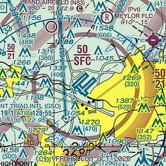
| Sectional chart |
|---|
|
CAUTION: Diagram may not be current
 Download PDF
of official airport diagram from the FAA
| Airport distance calculator |
|---|
|
|
| Sunrise and sunset |
|---|
|
Times for 03-Mar-2026
| | Local
(UTC-5) | | Zulu
(UTC) |
|---|
| Morning civil twilight | | 06:23 | | 11:23 |
| Sunrise | | 06:48 | | 11:48 |
| Sunset | | 18:15 | | 23:15 |
| Evening civil twilight | | 18:41 | | 23:41 |
|
| Current date and time |
|---|
| Zulu (UTC) | 04-Mar-2026 02:29:23 |
|---|
| Local (UTC-5) | 03-Mar-2026 21:29:23 |
|---|
|
| METAR |
|---|
| KGSO | 040215Z 18005KT 10SM FEW012 BKN250 09/07 A3032 RMK AO2 T00890072
|
KINT
13nm W | 040212Z 18003KT 10SM BKN019 OVC110 09/07 A3032 RMK AO2 T00890072 $
|
|
| TAF |
|---|
| KGSO | 032111Z 0321/0418 21006KT P6SM OVC012 FM032300 21008KT P6SM SCT025 BKN100 FM040600 23005KT 6SM BR BKN020 FM041400 23007KT P6SM SCT020 BKN250
|
KINT
13nm W | 032112Z 0321/0418 21006KT P6SM OVC012 FM040000 21008KT P6SM SCT025 BKN100 FM040600 24002KT 6SM BR BKN015 FM041400 23005KT P6SM SCT015 BKN250 AMD NOT SKED
|
|
| NOTAMs |
|---|
NOTAMs are issued by the DoD/FAA and will open in a separate window not controlled by AirNav.
|
|


