FAA INFORMATION EFFECTIVE 02 OCTOBER 2025
Location
| FAA Identifier: | HSV |
| Lat/Long: | 34-38-13.9090N 086-46-30.1950W
34-38.231817N 086-46.503250W
34.6371969,-86.7750542
(estimated) |
| Elevation: | 628.9 ft. / 191.7 m (surveyed) |
| Variation: | 04W (2020) |
| From city: | 9 miles SW of HUNTSVILLE, AL |
| Time zone: | UTC -5 (UTC -6 during Standard Time) |
| Zip code: | 35824 |
Airport Operations
| Airport use: | Open to the public |
| Activation date: | 05/1964 |
| Control tower: | yes |
| ARTCC: | MEMPHIS CENTER |
| FSS: | ANNISTON FLIGHT SERVICE STATION |
| NOTAMs facility: | HSV (NOTAM-D service available) |
| Attendance: | CONTINUOUS |
| Wind indicator: | lighted |
| Segmented circle: | yes |
| Lights: | ACTVT MALSR RWY 18L, 36L & 36R; HIRL RWY 18L/36R & 18R/36L - CTAF. RWY 18R ALSF ON STEP 2 WHEN ATCT CLSD. |
| Beacon: | white-green (lighted land airport)
Operates sunset to sunrise. |
| Fire and rescue: | ARFF index C |
| Airline operations: | CTC HSV ARFF ON CTAF OR PHONE 256-461-1115 FOR EMERG WHEN ATCT CLSD. |
| International operations: | customs landing rights airport |
Airport Communications
| CTAF: | 127.6 |
| UNICOM: | 122.95 |
| ATIS: | 121.25 |
| WX ASOS: | 121.25 (256-207-5925) |
| HUNTSVILLE GROUND: | 121.9 269.525 [0600-0000] |
| HUNTSVILLE TOWER: | 127.6 350.35 [0600-0000] |
| HUNTSVILLE APPROACH: | 118.05 ;185-004 125.6 ;005-184 239.0 ;185-004 354.1 ;005-184 [0600-0000] |
| MEMPHIS ARTCC APPROACH: | 118.75 [0000-0600] |
| HUNTSVILLE DEPARTURE: | 118.05 ;185-004 125.6 ;005-184 239.0 ;185-004 354.1 ;005-184 [0600-0000] |
| CLEARANCE DELIVERY: | 120.35 |
| CLASS C: | 118.05 ;185-004 125.6 ;005-184 239.0 ;185-004 354.1 ;005-184 |
| EMERG: | 121.5 243.0 |
| IC: | 125.6 ;005-184 354.1 ;005-184 |
| WX ASOS at DCU (8 nm W): | 118.375 (256-350-4270) |
| WX AWOS-3PT at MDQ (17 nm NE): | 120.000 (256-829-1242) |
- APCH/DEP SVC PRVDD BY MEMPHIS ARTCC ON FREQS 120.8/307.0 (HUNTSVILLE RCAG) WHEN HUNTSVILLE APCH CTL CLSD.
Nearby radio navigation aids
| VOR radial/distance | | VOR name | | Freq | | Var |
|---|
| RQZr214/11.9 | | ROCKET VORTAC | | 112.20 | | 02E |
Airport Services
| Fuel available: | 100LL JET-A |
| Parking: | hangars and tiedowns |
| Airframe service: | MAJOR |
| Powerplant service: | MAJOR |
| Bottled oxygen: | HIGH/LOW |
| Bulk oxygen: | HIGH/LOW |
Runway Information
Runway 18R/36L
| Dimensions: | 12600 x 150 ft. / 3840 x 46 m |
| Surface: | asphalt/concrete/grooved, in excellent condition |
| Weight bearing capacity: | | Single wheel: | 120.0 | | Double wheel: | 250.0 | | Double tandem: | 550.0 | | Dual double tandem: | 1114.0 |
|
| Runway edge lights: | high intensity |
| RUNWAY 18R | | RUNWAY 36L |
| Latitude: | 34-39.167130N | | 34-37.090260N |
| Longitude: | 086-46.926028W | | 086-46.967450W |
| Elevation: | 628.4 ft. | | 611.2 ft. |
| Traffic pattern: | right | | left |
| Runway heading: | 185 magnetic, 181 true | | 005 magnetic, 001 true |
| Declared distances: | TORA:12600 TODA:12600 ASDA:12600 LDA:12600 | | TORA:12600 TODA:12600 ASDA:12600 LDA:12600 |
| Markings: | precision, in good condition | | precision, in good condition |
| RVR equipment: | touchdown, midfield, rollout | | touchdown, midfield, rollout |
| Approach lights: | ALSF2: standard 2,400 foot high intensity approach lighting system with centerline sequenced flashers (category II or III) | | MALSR: 1,400 foot medium intensity approach lighting system with runway alignment indicator lights |
| Runway end identifier lights: | no | | no |
| Centerline lights: | yes | | yes |
| Touchdown point: | yes, lighted | | yes, lighted |
| Instrument approach: | ILS | | ILS/DME |
Runway 18L/36R
| Dimensions: | 10001 x 150 ft. / 3048 x 46 m |
| Surface: | asphalt/grooved, in excellent condition |
| Weight bearing capacity: | | Single wheel: | 120.0 | | Double wheel: | 247.0 | | Double tandem: | 435.0 | | Dual double tandem: | 972.0 |
|
| Runway edge lights: | high intensity |
| RUNWAY 18L | | RUNWAY 36R |
| Latitude: | 34-39.185908N | | 34-37.537492N |
| Longitude: | 086-45.927885W | | 086-45.961032W |
| Elevation: | 609.3 ft. | | 588.6 ft. |
| Traffic pattern: | left | | right |
| Runway heading: | 185 magnetic, 181 true | | 005 magnetic, 001 true |
| Displaced threshold: | no | | 200 ft. |
| Declared distances: | TORA:10001 TODA:10001 ASDA:9801 LDA:9801 | | TORA:10001 TODA:10001 ASDA:10001 LDA:9801 |
| Markings: | precision, in good condition | | precision, in good condition |
| Visual slope indicator: | 4-light PAPI on right (3.00 degrees glide path) | | 4-light PAPI on right (3.00 degrees glide path) |
| RVR equipment: | touchdown, rollout | | touchdown, rollout |
| Approach lights: | MALSR: 1,400 foot medium intensity approach lighting system with runway alignment indicator lights | | MALSR: 1,400 foot medium intensity approach lighting system with runway alignment indicator lights |
| Runway end identifier lights: | no | | no |
| Touchdown point: | yes, no lights | | yes, no lights |
| Instrument approach: | ILS | | ILS/DME |
Airport Ownership and Management from official FAA records
| Ownership: | Publicly-owned |
| Owner: | HUNTSVILLE MADISON COUNTY
1000 GLENN HEARN BLVD,
HUNTSVILLE, AL 35824
Phone 256-772-9395
AIRPORT AUTHORITY |
| Manager: | BUTCH ROBERTS
1000 GLENN HEARN BLVD,, BOX 20008
HUNTSVILLE, AL 35824
Phone 256-258-1958 |
Additional Remarks
| A39-18R/36L | PCR VALUE: 768/F/B/X/T |
| A39-18L/36R | PCR VALUE: 620/F/B/X/T |
| A57-36R | OBSTN CLNC SLOPE 50:1 AT DSPLCD THR. |
| - | LINE UP AND WAIT NA. |
| - | FOR CD WHEN TWR CLSD, IF UNA TO CTC ON FSS FREQ, CTC MEMPHIS ARTCC AT 901-368-8453/8449. |
| - | FLT NOTIFICATION SVC (ADCUS) AVBL. |
| - | INTXN OF TWY J AND SERVICE RD IS UNCONTROLLED. |
Instrument Procedures
NOTE: All procedures below are presented as PDF files. If you need a reader for these files, you should download the free Adobe Reader.NOT FOR NAVIGATION. Please procure official charts for flight.
FAA instrument procedures published for use from 02 October 2025 at 0901Z to 30 October 2025 at 0900z.
IAPs - Instrument Approach Procedures |
|---|
| ILS OR LOC RWY 18L | |
download (385KB) |
| ILS OR LOC RWY 18R | |
download (343KB) |
| ILS OR LOC RWY 36L | |
download (347KB) |
| ILS OR LOC RWY 36R | |
download (425KB) |
| ILS RWY 18R (CAT II) | |
download (299KB) |
| RNAV (GPS) RWY 18L | |
download (368KB) |
| RNAV (GPS) RWY 18R | |
download (314KB) |
| RNAV (GPS) RWY 36L | |
download (349KB) |
| RNAV (GPS) RWY 36R | |
download (355KB) |
| Radar Approach Procedures available | |
download (153KB) |
| NOTE: Special Alternate Minimums apply | |
download (158KB) |
Departure Procedures |
|---|
| HUNTSVILLE FOUR | |
download (210KB) |
| NOTE: Special Take-Off Minimums/Departure Procedures apply | |
download (479KB) |
Other nearby airports with instrument procedures:
KHUA - Redstone Army Airfield (5 nm NE)
KDCU - Pryor Field Regional Airport (8 nm W)
5M0 - Hartselle/Morgan County Regional Airport (16 nm SW)
KMDQ - Huntsville Executive Airport / Tom Sharp Jr Field (17 nm NE)
KCMD - Cullman Regional Airport/Folsom Field (22 nm S)
|
|

Road maps at:
MapQuest
Bing
Google
| Aerial photo |
|---|
WARNING: Photo may not be current or correct
 Photo courtesy of sellersphoto.com
Photo taken 26-May-2017
looking north.
Photo courtesy of sellersphoto.com
Photo taken 26-May-2017
looking north.
Do you have a better or more recent aerial photo of Huntsville International Airport-Carl T Jones Field that you would like to share? If so, please send us your photo.
|
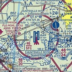
| Sectional chart |
|---|
|
 Download PDF
of official airport diagram from the FAA
| Airport distance calculator |
|---|
|
|
| Sunrise and sunset |
|---|
|
Times for 14-Oct-2025
| | Local
(UTC-5) | | Zulu
(UTC) |
|---|
| Morning civil twilight | | 06:28 | | 11:28 |
| Sunrise | | 06:53 | | 11:53 |
| Sunset | | 18:13 | | 23:13 |
| Evening civil twilight | | 18:39 | | 23:39 |
|
| Current date and time |
|---|
| Zulu (UTC) | 14-Oct-2025 12:48:17 |
|---|
| Local (UTC-5) | 14-Oct-2025 07:48:17 |
|---|
|
| METAR |
|---|
| KHSV | 141153Z 36003KT 10SM CLR 13/11 A3013 RMK AO2 SLP198 T01330111 10156 20117 53015 $
|
KHUA
5nm NE | 141220Z 35005KT 7SM CLR 14/11 A3014 RMK SLPNO RVRNO $
|
KDCU
9nm W | 141153Z AUTO 02007KT 10SM CLR 13/11 A3014 RMK AO2 SLP202 T01280106 10150 20122 53015 $
|
KMDQ
18nm NE | 141235Z AUTO 00000KT 10SM CLR 11/11 A3016 RMK A02 T01110107
|
|
| TAF |
|---|
| KHSV | 141120Z 1412/1512 02003KT P6SM SKC FM141500 03009G16KT P6SM SKC FM150100 02006KT P6SM SKC
|
KHUA
5nm NE | 141200Z 1412/1518 VRB06KT 9999 SKC QNH3008INS BECMG 1416/1417 02010G22KT 9999 SKC QNH3011INS BECMG 1422/1423 02009KT 9999 SKC QNH3004INS BECMG 1515/1516 05006KT 9999 SCT010 QNH3009INS TX27/1420Z TN12/1512Z
|
|
| NOTAMs |
|---|
NOTAMs are issued by the DoD/FAA and will open in a separate window not controlled by AirNav.
|
|


