FAA INFORMATION EFFECTIVE 22 JANUARY 2026
Location
| FAA Identifier: | I22 |
| Lat/Long: | 40-10-03.7000N 084-55-45.8000W
40-10.061667N 084-55.763333W
40.1676944,-84.9293889
(estimated) |
| Elevation: | 1122.8 ft. / 342.2 m (surveyed) |
| Variation: | 05W (2010) |
| From city: | 3 miles E of WINCHESTER, IN |
| Time zone: | UTC -5 (UTC -4 during Daylight Saving Time) |
| Zip code: | 47394 |
Airport Operations
| Airport use: | Open to the public |
| Activation date: | 06/1948 |
| Control tower: | no |
| ARTCC: | INDIANAPOLIS CENTER |
| FSS: | TERRE HAUTE FLIGHT SERVICE STATION |
| NOTAMs facility: | HUF (NOTAM-D service available) |
| Attendance: | MON-SAT 0800-1700, ALL SUN 1300-1700
ARPT CLSD THANKSGIVING & CHRISTMAS DAY. |
| Pattern altitude: | 1922.8 ft. MSL |
| Wind indicator: | lighted |
| Segmented circle: | no |
| Lights: | ACTVT MIRL RY 08/26; REIL RY 08/26; PAPI RY 08/26 - CTAF. |
| Beacon: | white-green (lighted land airport)
Operates sunset to sunrise. |
Airport Communications
| CTAF/UNICOM: | 123.0 |
| COLUMBUS APPROACH: | 134.45 |
| COLUMBUS DEPARTURE: | 134.45 |
| WX AWOS-3 at PLD (17 nm N): | 124.675 (260-726-7882) |
| WX AWOS-3PT at VES (18 nm E): | 125.9 (937-526-3154) |
Nearby radio navigation aids
| VOR radial/distance | | VOR name | | Freq | | Var |
|---|
| MIEr104/21.7 | | MUNCIE VOR/DME | | 114.40 | | 03W |
| DQNr291/26.1 | | DAYTON VOR/DME | | 114.50 | | 01W |
| MZZr123/39.5 | | MARION VOR/DME | | 108.60 | | 03W |
| NDB name | | Hdg/Dist | | Freq | | Var | | ID |
|---|
| NEW CASTLE | | 052/24.9 | | 385 | | 06W | | UWL | ..- .-- .-.. |
Airport Services
| Fuel available: | 100LL JET-A |
| Parking: | hangars and tiedowns |
| Airframe service: | MINOR |
| Powerplant service: | MINOR |
| Bottled oxygen: | NONE |
| Bulk oxygen: | NONE |
Runway Information
Runway 8/26
| Dimensions: | 4300 x 75 ft. / 1311 x 23 m |
| Surface: | asphalt/grooved, in excellent condition |
| Weight bearing capacity: | | PCN 21 /F/A/X/T | | Single wheel: | 64.0 | | Double wheel: | 90.0 | | Double tandem: | 176.0 |
|
| Runway edge lights: | medium intensity |
| RUNWAY 8 | | RUNWAY 26 |
| Latitude: | 40-09.983400N | | 40-10.139360N |
| Longitude: | 084-56.212758W | | 084-55.312257W |
| Elevation: | 1115.9 ft. | | 1122.8 ft. |
| Traffic pattern: | left | | left |
| Runway heading: | 082 magnetic, 077 true | | 262 magnetic, 257 true |
| Markings: | nonprecision, in good condition | | nonprecision, in good condition |
| Visual slope indicator: | 2-light PAPI on left (3.00 degrees glide path) | | 2-light PAPI on left (3.00 degrees glide path) |
| Runway end identifier lights: | yes | | yes |
| Touchdown point: | yes, no lights | | yes, no lights |
| Obstructions: | 17 ft. crops, 780 ft. from runway, 210 ft. right of centerline, 34:1 slope to clear | | 13 ft. road, 650 ft. from runway, 34:1 slope to clear |
Airport Ownership and Management from official FAA records
| Ownership: | Publicly-owned |
| Owner: | RANDOLPH CO BOAC
2937 E STATE RD32
WINCHESTER, IN 47394
Phone 765-584-3611 |
| Manager: | ERIC LIVINGSTON
2937 E STATE RD 32
WINCHESTER, IN 47394
Phone 765-584-3611 |
Additional Remarks
| - | COLUMBUS APCH CD (614) 338-8537. |
Instrument Procedures
NOTE: All procedures below are presented as PDF files. If you need a reader for these files, you should download the free Adobe Reader.NOT FOR NAVIGATION. Please procure official charts for flight.
FAA instrument procedures published for use from 22 January 2026 at 0901Z to 19 February 2026 at 0900z.
IAPs - Instrument Approach Procedures |
|---|
| RNAV (GPS) RWY 08 **CHANGED** | |
download (190KB) |
| RNAV (GPS) RWY 26 **CHANGED** | |
download (240KB) |
| VOR-A **CHANGED** | |
download (154KB) |
| NOTE: Special Take-Off Minimums/Departure Procedures apply | |
download (164KB) |
Other nearby airports with instrument procedures:
KPLD - Portland Municipal Airport (17 nm N)
KVES - Darke County Airport (18 nm E)
KMIE - Delaware County Regional Airport (22 nm W)
KRID - Richmond Municipal Airport (25 nm S)
KUWL - New Castle Henry County Airport / Marlatt Field (25 nm SW)
|
|

Road maps at:
MapQuest
Bing
Google
| Aerial photo |
|---|
WARNING: Photo may not be current or correct
 Photo courtesy of Butler, Fairman & Seufert, Inc.
Photo taken 11-Nov-2013
looking west.
Photo courtesy of Butler, Fairman & Seufert, Inc.
Photo taken 11-Nov-2013
looking west.
Do you have a better or more recent aerial photo of Randolph County Airport that you would like to share? If so, please send us your photo.
|
| Sectional chart |
|---|
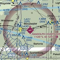
|
| Airport distance calculator |
|---|
|
|
| Sunrise and sunset |
|---|
|
Times for 01-Feb-2026
| | Local
(UTC-5) | | Zulu
(UTC) |
|---|
| Morning civil twilight | | 07:21 | | 12:21 |
| Sunrise | | 07:50 | | 12:50 |
| Sunset | | 17:57 | | 22:57 |
| Evening civil twilight | | 18:26 | | 23:26 |
|
| Current date and time |
|---|
| Zulu (UTC) | 01-Feb-2026 17:57:17 |
|---|
| Local (UTC-5) | 01-Feb-2026 12:57:17 |
|---|
|
| METAR |
|---|
KPLD
17nm N | 011755Z AUTO 27005KT 5SM HZ BKN004 M09/M14 A3030 RMK AO2 6//// T10891139
|
KVES
18nm E | 011736Z AUTO 19003KT 10SM CLR M10/M14 A3030 RMK AO2
|
KMIE
22nm W | 011753Z 28006KT 10SM CLR M06/M10 A3029 RMK AO2 SLP274 I6000 T10561100 11056 21206 58010
|
KRID
25nm S | 011755Z AUTO 18006KT 10SM CLR M10/M13 A3031 RMK AO2
|
KUWL
25nm SW | 011735Z AUTO 23004KT 10SM FEW007 M10/M12 A3030 RMK A01
|
KAID
32nm W | 011335Z AUTO 00000KT 10SM CLR A3033 RMK AO2
|
|
| TAF |
|---|
KDAY
36nm SE | 011143Z 0112/0212 31005KT P6SM FEW025 FM011800 25008KT P6SM FEW015 SCT250 FM020000 22005KT P6SM SCT015 TEMPO 0209/0212 4SM BR
|
|
| NOTAMs |
|---|
NOTAMs are issued by the DoD/FAA and will open in a separate window not controlled by AirNav.
|
|

