FAA INFORMATION EFFECTIVE 19 MARCH 2026
Location
| FAA Identifier: | FKN |
| Lat/Long: | 36-42-01.0670N 076-54-07.6880W
36-42.017783N 076-54.128133W
36.7002964,-76.9021356
(estimated) |
| Elevation: | 40.3 ft. / 12.3 m (surveyed) |
| Variation: | 09W (1985) |
| From city: | 2 miles NE of FRANKLIN, VA |
| Time zone: | UTC -4 (UTC -5 during Standard Time) |
| Zip code: | 23851 |
Airport Operations
| Airport use: | Open to the public |
| Activation date: | 08/1937 |
| Control tower: | no |
| ARTCC: | WASHINGTON CENTER |
| FSS: | LEESBURG FLIGHT SERVICE STATION |
| NOTAMs facility: | FKN (NOTAM-D service available) |
| Attendance: | 0800-1700 |
| Pattern altitude: | TPA LGT ACFT 800 FT, HVY ACFT 1500 FT. |
| Wind indicator: | lighted |
| Segmented circle: | no |
| Lights: | ACTVT MIRL 09/27 - CTAF. |
| Beacon: | white-green (lighted land airport)
Operates sunset to sunrise. |
Airport Communications
| CTAF/UNICOM: | 122.8 |
| WX AWOS-3PT: | 124.675 (757-562-8765) |
| NORFOLK APPROACH: | 127.9 |
| NORFOLK DEPARTURE: | 127.9 |
| WX AWOS-3 at SFQ (15 nm E): | 119.375 (757-934-3942) |
| WX ASOS at AKQ (18 nm N): | 128.325 (757-684-3011) |
Nearby radio navigation aids
| VOR radial/distance | | VOR name | | Freq | | Var |
|---|
| ORFr258/35.6 | | NORFOLK VORTAC | | 116.90 | | 07W |
| HPWr171/39.1 | | HOPEWELL VORTAC | | 114.35 | | 06W |
| NDB name | | Hdg/Dist | | Freq | | Var | | ID |
|---|
| WAKEFIELD | | 175/17.6 | | 274 | | 11W | | AKQ | .- -.- --.- |
| WOODVILLE | | 322/39.2 | | 254 | | 10W | | LLW | .-.. .-.. .-- |
Airport Services
| Fuel available: | 100LL JET-A |
| Parking: | tiedowns |
| Airframe service: | MAJOR |
| Powerplant service: | MAJOR |
| Bottled oxygen: | NONE |
| Bulk oxygen: | NONE |
Runway Information
Runway 9/27
| Dimensions: | 4977 x 100 ft. / 1517 x 30 m |
| Surface: | asphalt/grooved, in good condition |
| Runway edge lights: | medium intensity |
| RUNWAY 9 | | RUNWAY 27 |
| Latitude: | 36-41.953348N | | 36-42.082180N |
| Longitude: | 076-54.631108W | | 076-53.625160W |
| Elevation: | 33.3 ft. | | 40.3 ft. |
| Traffic pattern: | left | | left |
| Runway heading: | 090 magnetic, 081 true | | 270 magnetic, 261 true |
| Markings: | nonprecision, in fair condition | | nonprecision, in fair condition |
| Visual slope indicator: | 2-light PAPI on left (3.00 degrees glide path) | | 2-light PAPI on left (3.00 degrees glide path)
RWY 27 PAPI UNUSABLE BYD 1 NM FM THR. |
| Touchdown point: | yes, no lights | | yes, no lights |
| Obstructions: | 29 ft. tree, 422 ft. from runway, 127 ft. left of centerline, 7:1 slope to clear | | 83 ft. tree, 1224 ft. from runway, 398 ft. left of centerline, 12:1 slope to clear
4 FT HIGH FENCE 139 FT FM RWY END, 242 FT L ON APCH. |
Airport Ownership and Management from official FAA records
| Ownership: | Publicly-owned |
| Owner: | CITY OF FRANKLIN
207 WEST SECOND AVENUE
FRANKLIN, VA 23851
Phone 757-562-8561 |
| Manager: | TREVELYN LINTON
32470 JOHN BEVERLY ROSE DR
FRANKLIN, VA 23851
Phone 757-562-8764
CTC 757-562-8575 FOR AFTER HOUR EMERGENCIES. |
Additional Remarks
| - | DEER ON AND INVOF ARPT. |
| - | PSBL TFC FM THE SOUTHAMPTON MEMORIAL HELIPAD 2 NM W OF ARPT. |
| - | DRAINAGE DITCHES NEXT TO RWY & TWYS. |
| - | FOR CD CTC NORFOLK APCH AT 757-464-0757. |
| - | ARPT FBO CLSD SAT AND SUN. |
Instrument Procedures
NOTE: All procedures below are presented as PDF files. If you need a reader for these files, you should download the free Adobe Reader.NOT FOR NAVIGATION. Please procure official charts for flight.
FAA instrument procedures published for use from 19 March 2026 at 0901Z to 16 April 2026 at 0900Z.
IAPs - Instrument Approach Procedures |
|---|
| RNAV (GPS) RWY 09 **CHANGED** | |
download (166KB) |
| RNAV (GPS) RWY 27 **CHANGED** | |
download (185KB) |
| NOTE: Special Alternate Minimums apply | |
download (130KB) |
| NOTE: Special Take-Off Minimums/Departure Procedures apply | |
download (382KB) |
Other nearby airports with instrument procedures:
KSFQ - Suffolk Executive Airport (15 nm E)
KAKQ - Wakefield Municipal Airport (18 nm N)
KPVG - Hampton Roads Executive Airport (22 nm E)
KASJ - Tri-County Airport at Henry Joyner Field (27 nm SW)
KEMV - Emporia-Greensville Regional Airport (28 nm W)
|
|

Road maps at:
MapQuest
Bing
Google
| Aerial photo |
|---|
WARNING: Photo may not be current or correct
 Photo courtesy of AirNav, LLC
Photo taken 25-Jun-2011
looking south.
Photo courtesy of AirNav, LLC
Photo taken 25-Jun-2011
looking south.
Do you have a better or more recent aerial photo of Franklin Regional Airport that you would like to share? If so, please send us your photo.
|
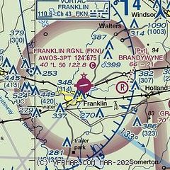
| Sectional chart |
|---|
|
| Airport distance calculator |
|---|
|
|
| Sunrise and sunset |
|---|
|
Times for 22-Mar-2026
| | Local
(UTC-4) | | Zulu
(UTC) |
|---|
| Morning civil twilight | | 06:43 | | 10:43 |
| Sunrise | | 07:09 | | 11:09 |
| Sunset | | 19:20 | | 23:20 |
| Evening civil twilight | | 19:46 | | 23:46 |
|
| Current date and time |
|---|
| Zulu (UTC) | 22-Mar-2026 06:14:09 |
|---|
| Local (UTC-4) | 22-Mar-2026 02:14:09 |
|---|
|
| METAR |
|---|
| KFKN | 220555Z AUTO 00000KT 10SM CLR 11/08 A2994 RMK AO2 T01130080 10176 20113
|
KSFQ
15nm E | 220555Z AUTO 14004KT 10SM CLR 12/10 A2995 RMK AO2 T01170101 10171 20115
|
KAKQ
18nm N | 220554Z AUTO VRB03KT 10SM CLR 11/09 A2992 RMK AO2 SLP131 T01110089 10172 20111 58013
|
|
| TAF |
|---|
KPHF
32nm NE | 220522Z 2206/2306 VRB05KT 6SM BR FEW250 FM221400 22008KT P6SM FEW250
|
KNGU
33nm NE | 2123/2223 09008G15KT 9999 FEW250 QNH2985INS FM220400 15010KT 9999 FEW250 QNH2982INS FM220800 21008KT 9999 FEW250 QNH2974INS TX27/2220Z TN09/2205Z FN00221
|
KLFI
34nm NE | 211730Z 2117/2223 01006KT 9999 FEW200 QNH2988INS BECMG 2119/2120 02010G20KT 9999 SCT040 SCT280 QNH2989INS BECMG 2204/2205 03009KT 6000 BR SCT010 BKN050 QNH2989INS BECMG 2213/2214 20010KT 9999 NSW SCT060 QNH2985INS TX22/2118Z TN09/2206Z LAST NO AMDS AFT 2117 NEXT 2305
|
|
| NOTAMs |
|---|
NOTAMs are issued by the DoD/FAA and will open in a separate window not controlled by AirNav.
|
|

