FAA INFORMATION EFFECTIVE 09 JULY 2026
Location
| FAA Identifier: | SFQ |
| Lat/Long: | 36-40-58.3984N 076-35-58.6434W
36-40.973307N 076-35.977390W
36.6828884,-76.5996232
(estimated) |
| Elevation: | 70.1 ft. / 21.4 m (surveyed) |
| Variation: | 10W (1995) |
| From city: | 3 miles SW of SUFFOLK, VA |
| Time zone: | UTC -4 (UTC -5 during Standard Time) |
| Zip code: | 23434 |
Airport Operations
| Airport use: | Open to the public |
| Activation date: | 10/1943 |
| Control tower: | no |
| ARTCC: | WASHINGTON CENTER |
| FSS: | LEESBURG FLIGHT SERVICE STATION |
| NOTAMs facility: | SFQ (NOTAM-D service available) |
| Attendance: | 0800-1700 |
| Wind indicator: | lighted |
| Segmented circle: | yes |
| Lights: | ACTVT REIL RWY 04 & 22; HIRL RWY 04/22 - CTAF. |
| Beacon: | white-green (lighted land airport)
Operates sunset to sunrise. |
Airport Communications
| CTAF/UNICOM: | 122.7 |
| WX AWOS-3: | 119.375 (757-934-3942) |
| NORFOLK APPROACH: | 127.9 |
| NORFOLK DEPARTURE: | 127.9 |
| KOHLS STAR: | 118.9 |
| OUTLA STAR: | 118.9 |
| WX AWOS-3PT at PVG (9 nm NE): | 118.375 (757-465-2175) |
| WX AWOS-3 at CPK (13 nm E): | 123.675 (757-204-4290) |
| WX AWOS-3PT at FKN (15 nm W): | 124.675 (757-562-8765) |
Nearby radio navigation aids
| VOR radial/distance | | VOR name | | Freq | | Var |
|---|
| ORFr244/22.9 | | NORFOLK VORTAC | | 116.90 | | 07W |
| ECGr328/32.7 | | ELIZABETH CITY VOR/DME | | 115.75 | | 07W |
| NDB name | | Hdg/Dist | | Freq | | Var | | ID |
|---|
| WAKEFIELD | | 144/26.4 | | 274 | | 11W | | AKQ | .- -.- --.- |
| WOODVILLE | | 340/29.1 | | 254 | | 10W | | LLW | .-.. .-.. .-- |
Airport Services
| Fuel available: | 100LL JET-A MOGAS |
| Parking: | tiedowns |
| Airframe service: | MAJOR |
| Powerplant service: | MAJOR |
| Bottled oxygen: | NONE |
| Bulk oxygen: | NONE |
Runway Information
Runway 4/22
| Dimensions: | 5007 x 100 ft. / 1526 x 30 m |
| Surface: | asphalt, in excellent condition |
| Weight bearing capacity: | | Single wheel: | 30.0 | | Double wheel: | 60.0 | | Double tandem: | 60.0 |
|
| Runway edge lights: | high intensity |
| RUNWAY 4 | | RUNWAY 22 |
| Latitude: | 36-40.568650N | | 36-41.283183N |
| Longitude: | 076-36.145852W | | 076-35.633507W |
| Elevation: | 66.3 ft. | | 68.8 ft. |
| Traffic pattern: | right | | left |
| Runway heading: | 040 magnetic, 030 true | | 220 magnetic, 210 true |
| Markings: | nonprecision, in good condition | | nonprecision, in good condition |
| Visual slope indicator: | 4-light PAPI on left (3.00 degrees glide path) | | 4-light PAPI on left (3.50 degrees glide path) |
| Runway end identifier lights: | yes | | yes |
| Touchdown point: | yes, no lights | | yes, no lights |
| Instrument approach: | LOC/DME | | |
| Obstructions: | 23 ft. tree, 820 ft. from runway, 281 ft. right of centerline, 26:1 slope to clear | | 97 ft. trees, 2317 ft. from runway, 195 ft. left of centerline, 21:1 slope to clear
12 FT TREE; 110 FT FM THLD, 220 RIGHT OF CNTRLN ON APCH CLNC SLP 9:1. |
Runway 7/25
| Dimensions: | 3750 x 100 ft. / 1143 x 30 m |
| Surface: | asphalt, in fair condition |
| Weight bearing capacity: | | Single wheel: | 30.0 | | Double wheel: | 50.0 | | Double tandem: | 85.0 |
|
| Runway edge markings: | RWY 25 MARKINGS IN POOR CONDITION. |
| RUNWAY 7 | | RUNWAY 25 |
| Latitude: | 36-40.899333N | | 36-41.173833N |
| Longitude: | 076-36.438333W | | 076-35.750667W |
| Elevation: | 68.1 ft. | | 66.7 ft. |
| Traffic pattern: | left | | right |
| Runway heading: | 074 magnetic, 064 true | | 254 magnetic, 244 true |
| Markings: | NSTD, in poor condition | | nonprecision, in poor condition |
| Touchdown point: | yes, no lights | | yes, no lights |
| Obstructions: | 85 ft. tree, 1904 ft. from runway, 163 ft. left of centerline, 20:1 slope to clear | | 64 ft. trees, 928 ft. from runway, 254 ft. left of centerline, 11:1 slope to clear |
Airport Ownership and Management from official FAA records
| Ownership: | Publicly-owned |
| Owner: | CITY OF SUFFOLK
PO BOX 1858
SUFFOLK, VA 23434
Phone 757-514-4000 |
| Manager: | TIM DANIEL
1200 GENE BOLTON DRIVE
SUFFOLK, VA 23434
Phone 757-514-4411 |
Additional Remarks
| - | DEER ON & INVOF ARPT. |
| - | FOR CD CTC NORFOLK APCH AT 757-464-0757. |
Instrument Procedures
NOTE: All procedures below are presented as PDF files. If you need a reader for these files, you should download the free Adobe Reader.NOT FOR NAVIGATION. Please procure official charts for flight.
FAA instrument procedures published for use from 09 July 2026 at 0901Z to 06 August 2026 at 0900Z.
STARs - Standard Terminal Arrivals |
|---|
| KOHLS ONE (RNAV) **NEW** | |
download (178KB) |
| OUTLA ONE (RNAV) **NEW** | |
2 pages:
[1] [2] (335KB) |
IAPs - Instrument Approach Procedures |
|---|
| RNAV (GPS) RWY 04 | |
download (226KB) |
| RNAV (GPS) RWY 22 | |
download (201KB) |
| LOC RWY 04 | |
download (231KB) |
| NOTE: Special Alternate Minimums apply | |
download (166KB) |
| NOTE: Special Take-Off Minimums/Departure Procedures apply | |
download (357KB) |
Other nearby airports with instrument procedures:
KPVG - Hampton Roads Executive Airport (9 nm NE)
KCPK - Chesapeake Regional Airport (13 nm E)
KFKN - Franklin Regional Airport (15 nm W)
KNGU - Norfolk Naval Station (Chambers Field) (21 nm NE)
KNHU - Norfolk Naval Station Airport (22 nm NE)
|
|

Road maps at:
MapQuest
Bing
Google
| Aerial photo |
|---|
WARNING: Photo may not be current or correct
 Photo by Bob Warwick
Taken in 2018
looking northeast.
Photo by Bob Warwick
Taken in 2018
looking northeast.
Do you have a better or more recent aerial photo of Suffolk Executive Airport that you would like to share? If so, please send us your photo.
|
| Sectional chart |
|---|
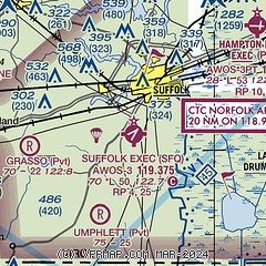
|
| Airport distance calculator |
|---|
|
|
| Sunrise and sunset |
|---|
|
Times for 26-Jul-2026
| | Local
(UTC-4) | | Zulu
(UTC) |
|---|
| Morning civil twilight | | 05:39 | | 09:39 |
| Sunrise | | 06:08 | | 10:08 |
| Sunset | | 20:17 | | 00:17 |
| Evening civil twilight | | 20:46 | | 00:46 |
|
| Current date and time |
|---|
| Zulu (UTC) | 26-Jul-2026 13:22:16 |
|---|
| Local (UTC-4) | 26-Jul-2026 09:22:16 |
|---|
|
| METAR |
|---|
| KSFQ | 261255Z AUTO 00000KT 10SM CLR 22/21 A2997 RMK AO2 LTG DSNT S AND W T02210205
|
KPVG
9nm NE | 261156Z AUTO 00000KT 10SM CLR 20/ A2996 RMK AO2 SLP147 70003 T0200 10200 20156 50008 $
|
KCPK
14nm E | 261255Z AUTO 32003KT 10SM CLR 22/19 A2996 RMK AO2 LTG DSNT W T02160185
|
KFKN
14nm W | 261255Z AUTO 00000KT 10SM CLR 20/19 A2996 RMK AO2 LTG DSNT S AND W T02020192
|
|
| TAF |
|---|
KNGU
21nm NE | 2607/2707 33008KT 9999 FEW030 SCT050 QNH2997INS FM261200 33008KT 9999 FEW045 SCT080 QNH2996INS FM261500 36008KT 9999 FEW060 QNH2996INS BECMG 2618/2620 09005KT 9999 FEW030 SCT060 QNH2993INS FM270500 04010KT 9999 VCSH SCT030 BKN060 QNH2990INS TX27/2618Z TN18/2609Z FN00319
|
KORF
23nm NE | 261120Z 2612/2712 35006KT P6SM FEW070 FM270200 17003KT P6SM BKN250
|
|
| NOTAMs |
|---|
NOTAMs are issued by the DoD/FAA and will open in a separate window not controlled by AirNav.
|
|

