FAA INFORMATION EFFECTIVE 14 MAY 2026
Location
| FAA Identifier: | FYJ |
| Lat/Long: | 37-31-16.9000N 076-45-45.9000W
37-31.281667N 076-45.765000W
37.5213611,-76.7627500
(estimated) |
| Elevation: | 20.4 ft. / 6.2 m (surveyed) |
| Variation: | 11W (2010) |
| From city: | 2 miles SE of WEST POINT, VA |
| Time zone: | UTC -4 (UTC -5 during Standard Time) |
| Zip code: | 23156 |
Airport Operations
| Airport use: | Open to the public |
| Activation date: | 07/1943 |
| Control tower: | no |
| ARTCC: | WASHINGTON CENTER |
| FSS: | LEESBURG FLIGHT SERVICE STATION |
| NOTAMs facility: | FYJ (NOTAM-D service available) |
| Attendance: | 0800-1700 |
| Pattern altitude: | TPA LGT ACFT 800 FT, HVY ACFT 1500 FT. |
| Wind indicator: | lighted |
| Segmented circle: | yes |
| Lights: | REIL RWY 10 & 28; MIRL 10/28 OPR SS-SR. DRG DALGT HRS, PCL AVBL ON REQ, CTC AMGR. ACTVT REIL RWY 10 & 28; MIRL 10/28 - CTAF. |
| Beacon: | white-green (lighted land airport)
Operates sunset to sunrise. |
Airport Communications
| CTAF/UNICOM: | 123.0 |
| WX AWOS-3: | 132.825 (804-785-2307) |
| POTOMAC APPROACH: | 126.4 126.75 |
| POTOMAC DEPARTURE: | 126.4 126.75 |
| WX AWOS-3 at W75 (16 nm E): | 118.45 (804-758-8592) |
| WX AWOS-3 at JGG (17 nm S): | 120.625 (757-220-8810) |
| WX AWOS-3 at W96 (17 nm W): | 119.875 (804-932-8863) |
Nearby radio navigation aids
| VOR radial/distance | | VOR name | | Freq | | Var |
|---|
| HCMr338/5.0 | | HARCUM VORTAC | | 108.80 | | 07W |
| HPWr062/20.4 | | HOPEWELL VORTAC | | 114.35 | | 06W |
| RICr097/26.6 | | RICHMOND VORTAC | | 114.10 | | 09W |
| NDB name | | Hdg/Dist | | Freq | | Var | | ID |
|---|
| WAKEFIELD | | 030/34.3 | | 274 | | 11W | | AKQ | .- -.- --.- |
Airport Services
| Fuel available: | 100LL JET-A+
100LL:SELF SVC AVBL.
A+:FULL & SELF SVC AVBL. |
| Parking: | tiedowns |
| Airframe service: | MAJOR |
| Powerplant service: | MAJOR |
| Bottled oxygen: | NONE |
| Bulk oxygen: | NONE |
Runway Information
Runway 10/28
| Dimensions: | 5000 x 75 ft. / 1524 x 23 m |
| Surface: | asphalt, in good condition |
| Weight bearing capacity: | | Single wheel: | 30.0 | | Double wheel: | 50.0 | | Double tandem: | 85.0 |
|
| Runway edge lights: | medium intensity |
| Runway edge markings: | NON-STD MARKING PLACEMENT. MARKINGS NEED TO SHIFT 8 FT E OF CURRENT PLACEMENT. |
| RUNWAY 10 | | RUNWAY 28 |
| Latitude: | 37-31.253085N | | 37-31.308563N |
| Longitude: | 076-46.280842W | | 076-45.248748W |
| Elevation: | 13.0 ft. | | 20.4 ft. |
| Traffic pattern: | left | | left |
| Runway heading: | 097 magnetic, 086 true | | 277 magnetic, 266 true |
| Markings: | nonprecision, in good condition | | nonprecision, in good condition |
| Visual slope indicator: | 2-light PAPI on left (3.50 degrees glide path) | | 2-light PAPI on left (3.50 degrees glide path) |
| Runway end identifier lights: | yes | | yes |
| Touchdown point: | yes, no lights | | yes, no lights |
| Instrument approach: | LOC/DME | | |
| Obstructions: | 10 ft. tree, 302 ft. from runway, 78 ft. left of centerline, 10:1 slope to clear
23 FT TREE; 161 FT FM THR, 243 FT R OF CNTRLN. | | 30 ft. trees, 336 ft. from runway, 137 ft. left of centerline, 4:1 slope to clear |
Airport Ownership and Management from official FAA records
| Ownership: | Publicly-owned |
| Owner: | MIDDLE PENISULA REG'L AIRPORT AUTHO
1000 AIRPORT RD
MATTAPONI, VA 23110
Phone 804-785-9725 |
| Manager: | JOEL MOONEY
1000 AIRPORT RD
MATTAPONI, VA 23110
Phone 804-785-9725
E-MAIL MANAGER@FLY-FYJ.COM. |
Additional Remarks
| - | DEER ON & INVOF ARPT. |
| - | ROTOR-WING AND TILTROTOR ACFT FLY TFC PATS SOUTH OF RWY 10/28 AT 800 FT AGL OR ABV. |
| - | FOR CD CTC NORFOLK APCH AT 757-464-0757. |
Instrument Procedures
NOTE: All procedures below are presented as PDF files. If you need a reader for these files, you should download the free Adobe Reader.NOT FOR NAVIGATION. Please procure official charts for flight.
FAA instrument procedures published for use from 14 May 2026 at 0901Z to 11 June 2026 at 0900Z.
IAPs - Instrument Approach Procedures |
|---|
| RNAV (GPS) RWY 10 | |
download (233KB) |
| RNAV (GPS)-B | |
download (162KB) |
| LOC RWY 10 | |
download (263KB) |
| VOR-A | |
download (165KB) |
| NOTE: Special Alternate Minimums apply | |
download (59KB) |
| NOTE: Special Take-Off Minimums/Departure Procedures apply | |
download (140KB) |
Other nearby airports with instrument procedures:
W94 - Camp Peary Landing Strip Airport (14 nm SE)
W75 - Hummel Field Airport (16 nm E)
KJGG - Waltrip Williamsburg Executive Airport (17 nm S)
W96 - New Kent County Airport (17 nm W)
KXSA - Tappahannock/Essex County Airport (21 nm N)
|
|

Road maps at:
MapQuest
Bing
Google
| Aerial photo |
|---|
WARNING: Photo may not be current or correct
 Photo by David Newcomer
Photo taken 10-Sep-2019
looking southwest from 5,000'.
Photo by David Newcomer
Photo taken 10-Sep-2019
looking southwest from 5,000'.
Do you have a better or more recent aerial photo of Middle Peninsula Regional Airport that you would like to share? If so, please send us your photo.
|
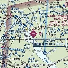
| Sectional chart |
|---|
|
| Airport distance calculator |
|---|
|
|
| Sunrise and sunset |
|---|
|
Times for 28-May-2026
| | Local
(UTC-4) | | Zulu
(UTC) |
|---|
| Morning civil twilight | | 05:20 | | 09:20 |
| Sunrise | | 05:50 | | 09:50 |
| Sunset | | 20:18 | | 00:18 |
| Evening civil twilight | | 20:49 | | 00:49 |
|
| Current date and time |
|---|
| Zulu (UTC) | 28-May-2026 05:56:19 |
|---|
| Local (UTC-4) | 28-May-2026 01:56:19 |
|---|
|
| METAR |
|---|
| KFYJ | 280535Z AUTO 25004KT 10SM BKN005 20/20 A2988 RMK AO1 T01980195
|
KW75
16nm E | 280535Z AUTO 25003KT 10SM SCT006 20/19 A2987 RMK AO1 T01970193
|
KJGG
17nm S | 280535Z AUTO 29003KT 10SM FEW150 20/20 A2987 RMK AO2 P0001 T02010199 $
|
KW96
17nm W | 280535Z AUTO 00000KT 5SM BKN002 19/19 A2987 RMK AO1 T01940192
|
|
| TAF |
|---|
KFAF
25nm S | 280300Z 2803/2908 18009KT 9999 FEW020 BKN060 BKN110 QNH2984INS TEMPO 2802/2804 8000 -SHRA BKN020 BECMG 2805/2806 VRB06KT 9999 FEW015 BKN060 QNH2981INS BECMG 2811/2812 31010G15KT 9999 SCT060 QNH2986INS BECMG 2813/2814 35012G18KT 9999 FEW060 QNH2987INS BECMG 2820/2821 35012G20KT 9999 BKN060 QNH2987INS TX27/2817Z TN21/2807Z LAST NO AMDS AFT 2803 NEXT 2810
|
KRIC
26nm W | 280254Z 2803/2824 22005KT P6SM SCT100 BKN150 FM280600 29005KT P6SM BKN015 FM281100 35008KT P6SM SCT050 FM281600 35012G20KT P6SM FEW060
|
KPHF
26nm SE | 280248Z 2803/2824 20004KT P6SM -RA OVC110 FM280400 25006KT P6SM VCSH BKN110 FM280800 30006KT P6SM BKN015 FM281200 34009KT P6SM BKN040 FM281600 01011G18KT P6SM FEW050
|
|
| NOTAMs |
|---|
NOTAMs are issued by the DoD/FAA and will open in a separate window not controlled by AirNav.
|
|

