FAA INFORMATION EFFECTIVE 18 APRIL 2024
Location
| FAA Identifier: | IRS |
| Lat/Long: | 41-48-47.8354N 085-26-20.2586W
41-48.797257N 085-26.337643W
41.8132876,-85.4389607
(estimated) |
| Elevation: | 924.8 ft. / 281.9 m (surveyed) |
| Variation: | 06W (2025) |
| From city: | 2 miles NW of STURGIS, MI |
| Time zone: | UTC -4 (UTC -5 during Standard Time) |
| Zip code: | 49091 |
Airport Operations
| Airport use: | Open to the public |
| Activation date: | 04/1940 |
| Control tower: | no |
| ARTCC: | CHICAGO CENTER |
| FSS: | LANSING FLIGHT SERVICE STATION |
| NOTAMs facility: | IRS (NOTAM-D service available) |
| Attendance: | MON-FRI 0800-1700 |
| Wind indicator: | lighted |
| Segmented circle: | no |
| Lights: | ACTVT REIL RWY 24, 01, & 19; PAPI RWY 24, 01, & 19; MIRL RWY 06/24 & 01/19 - CTAF. |
| Beacon: | white-green (lighted land airport)
Operates sunset to sunrise. |
Airport Communications
| CTAF/UNICOM: | 123.05 |
| WX AWOS-3: | 121.325 (269-659-8715) |
| GREAT LAKES APPROACH: | 121.2 |
| GREAT LAKES DEPARTURE: | 121.2 |
| CLEARANCE DELIVERY: | 118.325 |
| WX AWOS-3 at HAI (11 nm NW): | 119.975 (269-273-6705) |
| WX AWOS-3 at OEB (19 nm NE): | 118.125 (517-279-1810) |
| WX AWOS-3 at ANQ (19 nm SE): | 118.175 (260-668-5630) |
- APCH/DEP SVC PRVDD BY CHICAGO ARTCC ON FREQS 127.55/307.175 (GOSHEN RCAG) WHEN GREAT LAKES APCH CTL CLSD.
Nearby radio navigation aids
| VOR radial/distance | | VOR name | | Freq | | Var |
|---|
| GSHr057/31.6 | | GOSHEN VORTAC | | 113.70 | | 00E |
| OLKr007/(34.1) | | WEBSTER LAKE VOR | | 110.40 | | 03W |
| ELXr123/36.4 | | KEELER VOR/DME | | 116.60 | | 00E |
| GIJr086/39.4 | | GIPPER VORTAC | | 115.40 | | 00E |
| NDB name | | Hdg/Dist | | Freq | | Var | | ID |
|---|
| STURGIS | | at field | | 382 | | 04W | | IRS | .. .-. ... |
Airport Services
| Fuel available: | 100LL JET-A+ |
| Parking: | hangars and tiedowns |
| Airframe service: | MAJOR |
| Powerplant service: | MAJOR |
| Bottled oxygen: | LOW |
Runway Information
Runway 1/19
| Dimensions: | 5201 x 100 ft. / 1585 x 30 m |
| Surface: | asphalt, in good condition |
| Weight bearing capacity: | | Single wheel: | 47.0 | | Double wheel: | 57.5 | | Double tandem: | 90.0 |
|
| Runway edge lights: | medium intensity |
| RUNWAY 1 | | RUNWAY 19 |
| Latitude: | 41-48.357245N | | 41-49.213507N |
| Longitude: | 085-26.449453W | | 085-26.455665W |
| Elevation: | 912.0 ft. | | 908.2 ft. |
| Traffic pattern: | left | | left |
| Runway heading: | 006 magnetic, 360 true | | 186 magnetic, 180 true |
| Markings: | nonprecision, in good condition | | nonprecision, in good condition |
| Visual slope indicator: | 4-light PAPI on left (3.00 degrees glide path) | | 4-light PAPI on left (3.00 degrees glide path) |
| Runway end identifier lights: | yes | | yes |
| Touchdown point: | yes, no lights | | yes, no lights |
| Obstructions: | 55 ft. trees, 1700 ft. from runway, 150 ft. left of centerline, 27:1 slope to clear | | none |
Runway 6/24
| Dimensions: | 3601 x 75 ft. / 1098 x 23 m |
| Surface: | asphalt, in good condition |
| Weight bearing capacity: | | Single wheel: | 19.0 | | Double wheel: | 25.0 | | Double tandem: | 58.0 |
|
| Runway edge lights: | medium intensity |
| Runway edge markings: | FADED. |
| RUNWAY 6 | | RUNWAY 24 |
| Latitude: | 41-48.660333N | | 41-48.968500N |
| Longitude: | 085-26.510167W | | 085-25.833167W |
| Elevation: | 912.2 ft. | | 924.8 ft. |
| Traffic pattern: | left | | left |
| Runway heading: | 065 magnetic, 059 true | | 245 magnetic, 239 true |
| Markings: | basic, in poor condition | | basic, in poor condition |
| Visual slope indicator: | | | 2-light PAPI on left (4.00 degrees glide path) |
| Runway end identifier lights: | | | yes |
| Touchdown point: | yes, no lights | | yes, no lights |
| Obstructions: | none | | 75 ft. trees, 1450 ft. from runway, 125 ft. right of centerline, 16:1 slope to clear |
Airport Ownership and Management from official FAA records
| Ownership: | Publicly-owned |
| Owner: | CITY OF STURGIS
130 N NOTTAWA ST
STURGIS, MI 49091-1197
Phone 269-651-2321
ARPT/CITY MGR. |
| Manager: | ANDREW KUK, CITY MGR
130 N NOTTAWA ST, PO BOX 280
STURGIS, MI 49091-1197
Phone 269-651-2821
FBO. |
Airport Operational Statistics
| Aircraft based on the field: | | 24 | | Single engine airplanes: | | 24 |
| |  | |
| Aircraft operations: avg 22/day * | | 75% | transient general aviation | | 25% | local general aviation | | * for 12-month period ending 06 September 2016 | |
Additional Remarks
| - | FOR CD WHEN GREAT LAKES APCH CLSD CTC CHICAGO ARTCC AT 630-906-8921. |
| - | CALL FOR SNOW REMOVAL INFO & RWY COND RPRT. |
| - | DEER AND BIRDS ON & INVOF RWYS. |
Instrument Procedures
NOTE: All procedures below are presented as PDF files. If you need a reader for these files, you should download the free Adobe Reader.NOT FOR NAVIGATION. Please procure official charts for flight.
FAA instrument procedures published for use from 18 April 2024 at 0901Z to 16 May 2024 at 0900Z.
IAPs - Instrument Approach Procedures |
|---|
| RNAV (GPS) RWY 01 | |
download (273KB) |
| RNAV (GPS) RWY 19 **CHANGED** | |
download (246KB) |
| NDB RWY 19 | |
download (184KB) |
| NDB RWY 24 | |
download (184KB) |
| NOTE: Special Alternate Minimums apply | |
download (139KB) |
| NOTE: Special Take-Off Minimums/Departure Procedures apply | |
download (355KB) |
Other nearby airports with instrument procedures:
KHAI - Three Rivers Municipal/Dr Haines Airport (11 nm NW)
KOEB - Branch County Memorial Airport (19 nm NE)
KANQ - Tri-State Steuben County Airport (19 nm SE)
C62 - Kendallville Municipal Airport (22 nm S)
KGSH - Goshen Municipal Airport (23 nm SW)
|
|

Road maps at:
MapQuest
Bing
Google
| Aerial photo |
|---|
WARNING: Photo may not be current or correct
 Photo by AirNav, LLC
Photo taken 30-Sep-2010
looking east.
Photo by AirNav, LLC
Photo taken 30-Sep-2010
looking east.
Do you have a better or more recent aerial photo of Kirsch Municipal Airport that you would like to share? If so, please send us your photo.
|
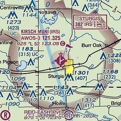
| Sectional chart |
|---|
|
| Airport distance calculator |
|---|
|
|
| Sunrise and sunset |
|---|
|
Times for 15-May-2024
| | Local
(UTC-4) | | Zulu
(UTC) |
|---|
| Morning civil twilight | | 05:50 | | 09:50 |
| Sunrise | | 06:22 | | 10:22 |
| Sunset | | 20:55 | | 00:55 |
| Evening civil twilight | | 21:26 | | 01:26 |
|
| Current date and time |
|---|
| Zulu (UTC) | 15-May-2024 04:11:05 |
|---|
| Local (UTC-4) | 15-May-2024 00:11:05 |
|---|
|
| METAR |
|---|
| KIRS | 150355Z AUTO 05008KT 7SM RA BKN005 OVC014 14/13 A2979 RMK AO2 P0019 T01400133
|
KHAI
11nm NW | 150355Z AUTO 06007KT 7SM -RA BKN029 OVC039 13/12 A2981 RMK AO2 T01270117
|
KANQ
19nm SE | 150355Z AUTO 06008KT 4SM -RA BR FEW010 OVC017 15/15 A2979 RMK AO2 P0004
|
KOEB
19nm E | 150355Z AUTO 04008KT 10SM -RA SCT030 BKN042 OVC095 14/14 A2981 RMK AO2 T01430135
|
|
| TAF |
|---|
KAZO
26nm N | 141914Z 1419/1518 02007KT P6SM VCSH SCT030 BKN060 FM142000 05010KT P6SM VCSH BKN035 FM150000 04008KT P6SM SCT025 BKN080 FM151500 03009KT P6SM BKN100
|
KBTL
32nm N | 141915Z 1419/1518 04007KT P6SM VCSH SCT018 BKN060 FM150000 04008KT P6SM SCT025 BKN080 FM151500 03009KT P6SM BKN100
|
|
| NOTAMs |
|---|
NOTAMs are issued by the DoD/FAA and will open in a separate window not controlled by AirNav.
|
|

