FAA INFORMATION EFFECTIVE 19 MARCH 2026
Location
| FAA Identifier: | MCO |
| Lat/Long: | 28-25-45.8000N 081-18-32.4000W
28-25.763333N 081-18.540000W
28.4293889,-81.3090000
(estimated) |
| Elevation: | 96.4 ft. / 29.4 m (surveyed) |
| Variation: | 06W (2015) |
| From city: | 6 miles SE of ORLANDO, FL |
| Time zone: | UTC -4 (UTC -5 during Standard Time) |
| Zip code: | 32827 |
Airport Operations
| Airport use: | Open to the public |
| Activation date: | 06/1941 |
| Control tower: | yes |
| ARTCC: | JACKSONVILLE CENTER |
| FSS: | SAINT PETERSBURG FLIGHT SERVICE STATION |
| NOTAMs facility: | MCO (NOTAM-D service available) |
| Attendance: | CONTINUOUS |
| Wind indicator: | lighted |
| Segmented circle: | no |
| Lights: | SS-SR |
| Beacon: | white-green (lighted land airport)
Operates sunset to sunrise. |
| Fire and rescue: | ARFF index E |
| International operations: | customs landing rights airport |
Airport Communications
| UNICOM: | 122.95 |
| WX ASOS: | PHONE 407-270-2241 |
| ORLANDO GROUND: | 121.8 ;WEST 126.4 ;EAST |
| ORLANDO TOWER: | 118.45 ;RWY 17L/35R, 17R/35L 124.3 ;RWY 18L/36R, 18R/36L 253.5 |
| ORLANDO APPROACH: | 119.4 ;061-180 4500 FT & BLW 119.4 ;181-310 5500 FT & BLW 120.15 120.15 ;181-359 ABV 5500 FT 124.8 124.8 ;000-180 ABV 5000 FT 135.3 ;311-060 5500 FT & BLW 123.85 134.05 |
| ORLANDO DEPARTURE: | 119.4 ;061-180 4500 FT & BLW 119.4 ;181-310 5500 FT & BLW 120.15 120.15 ;181-359 ABV 5500 FT 124.8 124.8 ;000-180 ABV 5000 FT 135.3 ;311-060 5500 FT & BLW |
| CLEARANCE DELIVERY: | 134.7 341.7 |
| ALYNA STAR: | 124.8 |
| AR OPS: | 148.8 41.5 |
| BITHO STAR: | 128.375 |
| CITRUS DP: | 119.4 |
| CLASS B: | 119.4 ;061-180 4500 FT & BLW 119.4 ;181-310 5500 FT & BLW 120.15 ;181-359 ABV 5500 FT 124.8 ;000-180 ABV 5500 FT 135.3 ;311-060 5500 FT & BLW |
| D-ATIS: | 120.525 ;DEP 121.25 ;ARR |
| DDANY DP: | 124.8 |
| EMERG: | 121.5 243.0 |
| FATHE DP: | 124.8 |
| FSHUN DP: | 120.15 |
| GRNCH STAR: | 134.05 |
| GTOUT STAR: | 128.375 |
| IC: | 124.8 ;000-180 ABV 5000 FT |
| JAFAR STAR: | 134.05 |
| JEEMY DP: | 120.15 ;DEPARTING SOUTH 124.8 ;DEPARTING NORTH |
| JOKRS STAR: | 134.05 |
| LEESE STAR: | 128.675 134.05 |
| MINEE STAR: | 134.05 |
| MUNGI STAR: | 128.375 |
| MZULO DP: | 124.8 |
| ORLANDO DP: | 120.15 ;WEST 124.8 ;EAST |
| OSPRY DP: | 120.15 |
| PRICY STAR: | 134.05 |
| RDSOX DP: | 120.15 |
| RIDES STAR: | 128.375 |
| SNFLD STAR: | 128.375 |
| WX ASOS at ORL (7 nm N): | 127.25 (407-658-6753) |
| WX AWOS-3PT at ISM (11 nm SW): | PHONE 407-847-0533 |
- ASDE-X IN USE. OPERATE TRANSPONDERS WITH ALTITUDE REPORTING MODE AND ADS-B (IF EQUIPPED) ENABLED ON ALL AIRPORT SURFACES.
- TWRPH# 407-852-7500.
Nearby radio navigation aids
| VOR radial/distance | | VOR name | | Freq | | Var |
|---|
| ORLr169/6.9 | | ORLANDO VORTAC | | 112.20 | | 00E |
Airport Services
| Fuel available: | 100LL JET-A |
| Parking: | hangars and tiedowns |
| Airframe service: | MINOR |
| Powerplant service: | MINOR |
| Bottled oxygen: | NONE |
| Bulk oxygen: | NONE |
Runway Information
Runway 18L/36R
| Dimensions: | 12005 x 200 ft. / 3659 x 61 m |
| Surface: | asphalt/concrete/grooved, in good condition
CENTER 75 FOOT KEEL SECTION OF RY CONCRETE FULL LENGTH; CENTER 100 FOOT KEEL SECTION OF RY CONCRETE FIRST 1000 FT, BOTH ENDS. REST OF RY WIDTH IS ASPHALT. |
| Weight bearing capacity: | | Single wheel: | 120.0 | | Double wheel: | 250.0 | | Double tandem: | 550.0 | | Dual double tandem: | 1117.0 |
|
| Runway edge lights: | high intensity |
| RUNWAY 18L | | RUNWAY 36R |
| Latitude: | 28-26.900063N | | 28-24.919115N |
| Longitude: | 081-19.338370W | | 081-19.317263W |
| Elevation: | 92.4 ft. | | 91.0 ft. |
| Traffic pattern: | left | | left |
| Runway heading: | 185 magnetic, 179 true | | 005 magnetic, 359 true |
| Declared distances: | TORA:12005 TODA:12005 ASDA:12005 LDA:12005 | | TORA:12005 TODA:12005 ASDA:11601 LDA:11601 |
| Markings: | precision, in good condition | | precision, in good condition |
| Visual slope indicator: | 4-light PAPI on left (3.00 degrees glide path) | | 4-light PAPI on left (3.00 degrees glide path) |
| RVR equipment: | touchdown, midfield, rollout | | touchdown, midfield, rollout |
| Approach lights: | | | ALSF2: standard 2,400 foot high intensity approach lighting system with centerline sequenced flashers (category II or III) |
| Centerline lights: | yes | | yes |
| Touchdown point: | yes, no lights | | yes, lighted |
| Instrument approach: | | | ILS/DME |
Runway 18R/36L
| Dimensions: | 12004 x 200 ft. / 3659 x 61 m |
| Surface: | asphalt/concrete/grooved, in good condition
CENTER 87 FOOT KEEL SECTION OF RY CONCRETE FULL LENGTH; REST OF RY WIDTH IS ASPHALT. LAST 3000 FT OF RY 18R IS CONCRETE FULL WIDTH. |
| Weight bearing capacity: | | Single wheel: | 120.0 | | Double wheel: | 250.0 | | Double tandem: | 550.0 | | Dual double tandem: | 1117.0 |
|
| Runway edge lights: | high intensity |
| RUNWAY 18R | | RUNWAY 36L |
| Latitude: | 28-26.897615N | | 28-24.916783N |
| Longitude: | 081-19.618485W | | 081-19.597157W |
| Elevation: | 92.5 ft. | | 91.1 ft. |
| Traffic pattern: | left | | left |
| Runway heading: | 185 magnetic, 179 true | | 005 magnetic, 359 true |
| Declared distances: | TORA:12004 TODA:12004 ASDA:12004 LDA:12004 | | TORA:12004 TODA:12004 ASDA:11621 LDA:11621 |
| Markings: | precision, in good condition | | precision, in good condition |
| Visual slope indicator: | 4-light PAPI on left (3.00 degrees glide path) | | 4-light PAPI on left (3.00 degrees glide path) |
| RVR equipment: | touchdown, midfield, rollout | | touchdown, midfield, rollout |
| Approach lights: | MALSR: 1,400 foot medium intensity approach lighting system with runway alignment indicator lights | | |
| Runway end identifier lights: | | | yes |
| Centerline lights: | yes | | yes |
| Touchdown point: | yes, lighted | | yes, no lights |
| Instrument approach: | ILS/DME | | ILS/DME |
Runway 17R/35L
| Dimensions: | 10000 x 150 ft. / 3048 x 46 m |
| Surface: | concrete/grooved, in good condition |
| Weight bearing capacity: | | Single wheel: | 120.0 | | Double wheel: | 250.0 | | Double tandem: | 550.0 | | Dual double tandem: | 1117.0 |
|
| Runway edge lights: | high intensity |
| RUNWAY 17R | | RUNWAY 35L |
| Latitude: | 28-26.136715N | | 28-24.486587N |
| Longitude: | 081-17.752760W | | 081-17.735558W |
| Elevation: | 90.1 ft. | | 86.7 ft. |
| Traffic pattern: | left | | left |
| Runway heading: | 185 magnetic, 179 true | | 005 magnetic, 359 true |
| Declared distances: | TORA:10000 TODA:10000 ASDA:10000 LDA:10000 | | TORA:10000 TODA:10000 ASDA:10000 LDA:10000 |
| Markings: | precision, in good condition | | precision, in good condition |
| Visual slope indicator: | 4-light PAPI on left (3.00 degrees glide path) | | 4-light PAPI on right (3.00 degrees glide path) |
| RVR equipment: | touchdown, midfield, rollout | | touchdown, midfield, rollout |
| Approach lights: | ALSF2: standard 2,400 foot high intensity approach lighting system with centerline sequenced flashers (category II or III) | | ALSF2: standard 2,400 foot high intensity approach lighting system with centerline sequenced flashers (category II or III) |
| Centerline lights: | yes | | yes |
| Touchdown point: | yes, lighted | | yes, lighted |
| Instrument approach: | ILS/DME | | ILS/DME |
Runway 17L/35R
| Dimensions: | 9001 x 150 ft. / 2744 x 46 m |
| Surface: | concrete/grooved, in good condition |
| Weight bearing capacity: | | Single wheel: | 120.0 | | Double wheel: | 250.0 | | Double tandem: | 550.0 | | Dual double tandem: | 1117.0 |
|
| Runway edge lights: | high intensity |
| RUNWAY 17L | | RUNWAY 35R |
| Latitude: | 28-26.621800N | | 28-25.136623N |
| Longitude: | 081-16.954873W | | 081-16.939670W |
| Elevation: | 89.7 ft. | | 89.7 ft. |
| Traffic pattern: | left | | left |
| Runway heading: | 185 magnetic, 179 true | | 005 magnetic, 359 true |
| Declared distances: | TORA:9001 TODA:9001 ASDA:9001 LDA:9001 | | TORA:9001 TODA:9001 ASDA:9001 LDA:9001 |
| Markings: | precision, in good condition | | precision, in good condition |
| Visual slope indicator: | 4-light PAPI on left (3.00 degrees glide path) | | 4-light PAPI on right (3.00 degrees glide path) |
| RVR equipment: | touchdown, midfield, rollout | | touchdown, midfield, rollout |
| Approach lights: | ALSF2: standard 2,400 foot high intensity approach lighting system with centerline sequenced flashers (category II or III) | | ALSF2: standard 2,400 foot high intensity approach lighting system with centerline sequenced flashers (category II or III) |
| Centerline lights: | yes | | yes |
| Touchdown point: | yes, lighted | | yes, lighted |
| Instrument approach: | ILS/DME | | ILS/DME |
Airport Ownership and Management from official FAA records
| Ownership: | Publicly-owned |
| Owner: | GREATER ORLANDO AVIATION AUTHORITY
1 JEFF FUQUA BLVD
ORLANDO, FL 32827-4399
Phone 407-825-2001 |
| Manager: | LANCE LYTTLE
1 JEFF FUQUA BLVD
ORLANDO, FL 32827-4399
Phone 407-825-2020 |
Additional Remarks
| A39-18R/36L | PCR VALUE: 1139/R/B/W/T |
| A39-18L/36R | PCR VALUE: 1028/R/B/W/T |
| A39-17L/35R | PCR VALUE: 1090/R/B/W/T |
| A39-17R/35L | PCR VALUE: 1139/R/B/W/T |
| - | BIRDS ON & INVOF ARPT. |
| - | USE CAUTION IN VCNTY OF TWY "A" ALONG WEST RAMP. |
| - | UNLESS ADV BY ATIS, DEP FLTS ON INITIAL CTC WITH GND CTL: ACFT ON WEST RAMP, AIRSIDE 1 & 3 (GATES 1-59) USE GND CTL 121.8. ACFT AT AIRSIDE 2 & 4 (GATES 60 AND HIGHER), USE GND CTL 126.4. |
| - | TWY J3 AND TWY J4 RSTD TO WINGSPAN OF LESS THAN 118 FT. |
| - | RUNWAY STATUS LIGHTS ARE IN OPERATION. |
| - | ACFT WITH WINGSPAN GREATER THAN 214 FT MUST ADHERE TO SPECIFIC RY AND TAXI ROUTES. CONTACT AIRFIELD OPS AT 407-825-2036 FOR DETAILS. |
| - | TWY A, SOUTH OF TWY A3 RSTD TO WINGSPAN OF LESS THAN 118 FT. PPR REQUIRED FOR WINGSPAN 118 FT OR GREATER. |
| - | 24 HR PPR FOR ACFT EQUIPPED WITH WEATHER MODIFICATION OR GEOENGINEERING EQPT 407-825-2036. |
| - | ALL AIRCRAFT DETERMINED TO BE FAA DESIGN GROUP IV AND ABOVE MUST PERFORM JUDGEMENTAL OVERSTEERING INSTEAD OF COCKPIT CNTRLN STEERING WHEN TAXIING. |
| - | WHEN ORL ILS RY 7 AND MCO ILS RYS 17 & 18R SIMULTANEOUS OPERATIONS ARE CONDUCTED, ATC RADAR REQUIRED. |
| - | BRIGHT LGTS ON ROAD BTN RY 17R/35L AND RY 17L/35R MAY BE MISTAKEN FOR RY LGTS. |
Instrument Procedures
NOTE: All procedures below are presented as PDF files. If you need a reader for these files, you should download the free Adobe Reader.NOT FOR NAVIGATION. Please procure official charts for flight.
FAA instrument procedures published for use from 19 March 2026 at 0901Z to 16 April 2026 at 0900Z.
STARs - Standard Terminal Arrivals |
|---|
| ALYNA FOUR (RNAV) | |
download (275KB) |
| BITHO SEVEN | |
download (215KB) |
| GRNCH FIVE (RNAV) | |
2 pages:
[1] [2] (432KB) |
| GTOUT ONE (RNAV) | |
download (194KB) |
| JAFAR THREE (RNAV) | |
2 pages:
[1] [2] (347KB) |
| JOKRS FOUR (RNAV) **NEW** | |
2 pages:
[1] [2] (332KB) |
| LEESE THREE | |
2 pages:
[1] [2] (255KB) |
| MINEE SIX | |
2 pages:
[1] [2] (326KB) |
| MUNGI ONE (RNAV) **NEW** | |
2 pages:
[1] [2] (502KB) |
| PRICY FIVE (RNAV) **NEW** | |
2 pages:
[1] [2] (403KB) |
| PRICY FIVE (RNAV), CONT.2 **NEW** | |
download (152KB) |
| SHREK TWO (RNAV) | |
download (189KB) |
| SLOAO ONE (RNAV) | |
download (162KB) |
| SNFLD THREE (RNAV) | |
2 pages:
[1] [2] (307KB) |
IAPs - Instrument Approach Procedures |
|---|
| ILS OR LOC RWY 17L | |
download (339KB) |
| ILS OR LOC RWY 17R | |
download (334KB) |
| ILS OR LOC RWY 18R | |
download (289KB) |
| ILS OR LOC RWY 35L | |
download (319KB) |
| ILS OR LOC RWY 35R | |
download (336KB) |
| ILS OR LOC RWY 36L | |
download (295KB) |
| ILS OR LOC RWY 36R | |
download (312KB) |
| ILS RWY 17L (SA CAT I) | |
download (318KB) |
| ILS RWY 35L (SA CAT I) | |
download (303KB) |
| ILS RWY 35R (SA CAT I) | |
download (305KB) |
| ILS RWY 36R (SA CAT I) | |
download (271KB) |
| ILS RWY 17R (CAT II) | |
download (316KB) |
| ILS RWY 17L (CAT II - III) | |
download (316KB) |
| ILS RWY 35L (CAT II - III) | |
download (300KB) |
| ILS RWY 35R (CAT II - III) | |
download (303KB) |
| ILS RWY 36R (CAT II - III) | |
download (267KB) |
| RNAV (RNP) Z RWY 17L **NEW** | |
download (256KB) |
| RNAV (RNP) Z RWY 18R **NEW** | |
download (263KB) |
| RNAV (RNP) Z RWY 35R **NEW** | |
download (248KB) |
| RNAV (RNP) Z RWY 36L **NEW** | |
download (250KB) |
| RNAV (GPS) RWY 17R | |
download (262KB) |
| RNAV (GPS) RWY 18L | |
download (255KB) |
| RNAV (GPS) RWY 35L | |
download (288KB) |
| RNAV (GPS) RWY 36R | |
download (268KB) |
| RNAV (GPS) Y RWY 17L **NEW** | |
download (286KB) |
| RNAV (GPS) Y RWY 18R **NEW** | |
download (263KB) |
| RNAV (GPS) Y RWY 35R **NEW** | |
download (283KB) |
| RNAV (GPS) Y RWY 36L **NEW** | |
download (265KB) |
Departure Procedures |
|---|
| CITRUS ONE | |
download (158KB) |
| DDANY THREE (RNAV) | |
2 pages:
[1] [2] (426KB) |
| FATHE FOUR (RNAV) | |
2 pages:
[1] [2] (345KB) |
| FATHE FOUR (RNAV), CONT.2 | |
download (318KB) |
| FSHUN FOUR (RNAV) | |
2 pages:
[1] [2] (469KB) |
| JEEMY FOUR (RNAV) | |
2 pages:
[1] [2] (541KB) |
| MZULO THREE (RNAV) | |
2 pages:
[1] [2] (437KB) |
| ORLANDO SIX | |
download (222KB) |
| OSPRY ONE (RNAV) | |
2 pages:
[1] [2] (534KB) |
| RDSOX ONE (RNAV) | |
2 pages:
[1] [2] (513KB) |
| NOTE: Special Take-Off Minimums/Departure Procedures apply | |
download (281KB) |
Other nearby airports with instrument procedures:
KORL - Orlando Executive Airport (7 nm N)
KISM - Kissimmee Gateway Airport (11 nm SW)
KSFB - Orlando Sanford International Airport (21 nm N)
X04 - Orlando Apopka Airport (22 nm NW)
KTIX - Space Coast Regional Airport (27 nm E)
|
|

Road maps at:
MapQuest
Bing
Google
| Aerial photo |
|---|
WARNING: Photo may not be current or correct
 Photo by Russell Aerial Photography Inc.
Photo taken 30-Dec-2017
looking north.
Photo by Russell Aerial Photography Inc.
Photo taken 30-Dec-2017
looking north.
Do you have a better or more recent aerial photo of Orlando International Airport that you would like to share? If so, please send us your photo.
|
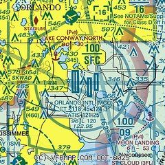
| Sectional chart |
|---|
|
CAUTION: Diagram may not be current
 Download PDF
of official airport diagram from the FAA
| Airport distance calculator |
|---|
|
|
| Sunrise and sunset |
|---|
|
Times for 02-Apr-2026
| | Local
(UTC-4) | | Zulu
(UTC) |
|---|
| Morning civil twilight | | 06:52 | | 10:52 |
| Sunrise | | 07:15 | | 11:15 |
| Sunset | | 19:43 | | 23:43 |
| Evening civil twilight | | 20:06 | | 00:06 |
|
| Current date and time |
|---|
| Zulu (UTC) | 02-Apr-2026 12:08:52 |
|---|
| Local (UTC-4) | 02-Apr-2026 08:08:52 |
|---|
|
| METAR |
|---|
| KMCO | 021153Z 03004KT 10SM FEW024 19/16 A3018 RMK AO2 SLP219 70003 T01890161 10189 20167 53012
|
KORL
7nm N | 021153Z 05004KT 10SM SCT031 19/16 A3017 RMK AO2 SLP221 T01890156 10189 20161 53013
|
KISM
11nm SW | 021156Z 00000KT 10SM CLR 19/16 A3018 RMK AO2 SLP221 7//// T01890161 10194 20167 53012 $
|
|
| TAF |
|---|
| KMCO | 021120Z 0212/0318 08005KT P6SM FEW030 FEW060 FM021400 11012KT P6SM SCT040 SCT300 FM021800 11014G22KT P6SM VCTS SCT040CB BKN070 FM030100 10007KT P6SM FEW025 SCT100 FM031400 11012KT P6SM BKN035
|
KISM
11nm SW | 021120Z 0212/0312 06005KT P6SM SKC FM021400 11012KT P6SM SCT040 FM021800 11012G20KT P6SM VCTS SCT040CB BKN070 FM030100 10007KT P6SM FEW025 SCT100
|
|
| NOTAMs |
|---|
NOTAMs are issued by the DoD/FAA and will open in a separate window not controlled by AirNav.
|
|


