FAA INFORMATION EFFECTIVE 19 MARCH 2026
Location
| FAA Identifier: | PAE |
| Lat/Long: | 47-54-26.3450N 122-16-55.5380W
47-54.439083N 122-16.925633W
47.9073181,-122.2820939
(estimated) |
| Elevation: | 606.9 ft. / 185.0 m (surveyed) |
| Variation: | 16E (2020) |
| From city: | 6 miles SW of EVERETT, WA |
| Time zone: | UTC -7 (UTC -8 during Standard Time) |
| Zip code: | 98275 |
Airport Operations
| Airport use: | Open to the public |
| Activation date: | 11/1938 |
| Control tower: | yes |
| ARTCC: | SEATTLE CENTER |
| FSS: | SEATTLE FLIGHT SERVICE STATION |
| NOTAMs facility: | PAE (NOTAM-D service available) |
| Attendance: | NOV-APR 0700-2100, MAY-OCT 0700-2100 |
| Wind indicator: | lighted |
| Segmented circle: | yes |
| Lights: | WHEN ATCT CLSD, ACTVT MALSR RWY 16R; MALSF 34L; HIRL RWY 16R/34L - CTAF. PAPI RWY 34L OPR CONSLY. |
| Beacon: | white-green (lighted land airport)
Operates sunset to sunrise. |
| Landing fee: | yes, LNDG FEE OVR 30000 LB GWT. |
| Fire and rescue: | ARFF index B |
| Airline operations: | CLSD TO UNSKED ACR OPS GTR THAN 30 PAX SEATS 2100-0700; EXC PPR - 425-388-5125. |
| International operations: | customs landing rights airport |
Airport Communications
| CTAF: | 132.95 |
| UNICOM: | 122.95 |
| ATIS: | 128.65 |
| WX ASOS: | PHONE 425-355-6192 |
| PAINE GROUND: | 121.8 339.8 [0700-2100] |
| PAINE TOWER: | 120.2 ;RWY 16L/34R 132.95 ;RWY 16R/34L 256.7 [0700-2100] |
| SEATTLE APPROACH: | 128.5 |
| SEATTLE DEPARTURE: | 128.5 |
| CLEARANCE DELIVERY: | 127.175 |
| AR OPS: | 34.1FM |
| IC: | 132.95 ;RWY 16R/34L |
| OLYMPIA STAR: | 125.6 |
| WX AWOS-3PT at AWO (16 nm N): | 135.625 (360-435-8045) |
Nearby radio navigation aids
| VOR radial/distance | | VOR name | | Freq | | Var |
|---|
| PAE at field | | PAINE VOR/DME | | 110.60 | | 20E |
| CVVr120/26.9 | | PENN COVE VOR/DME | | 117.20 | | 19E |
| SEAr343/28.3 | | SEATTLE VORTAC | | 116.80 | | 19E |
| NDB name | | Hdg/Dist | | Freq | | Var | | ID |
|---|
| WATON | | 190/11.4 | | 382 | | 17E | | AW | .- .-- |
Airport Services
| Fuel available: | 100LL JET-A
100LL:100LL SELF SVC H24 WITH CREDIT CARD AT CTL RAMP. HEL SELF SVC NA. AFT HR - 425-355-6600. |
| Parking: | hangars and tiedowns |
| Airframe service: | MAJOR |
| Powerplant service: | MAJOR |
| Bottled oxygen: | HIGH |
| Bulk oxygen: | HIGH |
Runway Information
Runway 16R/34L
| Dimensions: | 9010 x 150 ft. / 2746 x 46 m |
| Surface: | asphalt/concrete/grooved, in good condition
FIRST 1000 FT RWY 16R CONC. |
| Weight bearing capacity: | | Single wheel: | 114.0 | | Double wheel: | 189.0 | | Double tandem: | 320.0 | | Dual double tandem: | 770.0 |
|
| Runway edge lights: | high intensity |
| Operational restrictions: | WHEN ATCT CLSD INT DEP NA. TGL NA 0700-0900 MON-FRI. RUNUP AREA AT A4. |
| RUNWAY 16R | | RUNWAY 34L |
| Latitude: | 47-55.280147N | | 47-53.798400N |
| Longitude: | 122-17.151053W | | 122-17.118193W |
| Elevation: | 562.7 ft. | | 577.6 ft. |
| Traffic pattern: | right | | left |
| Runway heading: | 163 magnetic, 179 true | | 343 magnetic, 359 true |
| Declared distances: | TORA:9010 TODA:9010 ASDA:9010 LDA:9010 | | TORA:9010 TODA:9010 ASDA:9010 LDA:9010 |
| Markings: | precision, in good condition | | nonprecision, in good condition |
| Visual slope indicator: | 4-light PAPI on right (3.00 degrees glide path) | | 4-light PAPI on left (3.00 degrees glide path) |
| RVR equipment: | touchdown, rollout | | touchdown, rollout |
| Approach lights: | MALSR: 1,400 foot medium intensity approach lighting system with runway alignment indicator lights | | MALSF: 1,400 foot medium intensity approach lighting system with sequenced flashers |
| Centerline lights: | yes | | yes |
| Touchdown point: | yes, lighted | | yes, no lights |
| Instrument approach: | ILS | | |
| Obstructions: | none | | 125 ft. trees, 4000 ft. from runway, 930 ft. right of centerline, 30:1 slope to clear |
Runway 16L/34R
| Dimensions: | 3004 x 75 ft. / 916 x 23 m |
| Surface: | asphalt, in good condition |
| Weight bearing capacity: | | PCN 4 /F/B/Y/T | | Single wheel: | 12.5 |
|
| Runway edge lights: | medium intensity |
| Operational restrictions: | CLSD 0500-1500Z. AVOID INT DEP. LTD TO HEL 8000 LB OR LESS. RUNUP AREAS NEAR F1, F5, G4 & NON-MOV AREA W OF G1. |
| RUNWAY 16L | | RUNWAY 34R |
| Latitude: | 47-54.385483N | | 47-53.891497N |
| Longitude: | 122-16.301560W | | 122-16.296078W |
| Elevation: | 602.9 ft. | | 599.8 ft. |
| Traffic pattern: | left | | right |
| Runway heading: | 164 magnetic, 180 true | | 344 magnetic, 360 true |
| Declared distances: | TORA:3004 TODA:3004 ASDA:3004 LDA:3004 | | TORA:3004 TODA:3004 ASDA:3004 LDA:3004 |
| Markings: | basic, in good condition | | basic, in good condition |
| Visual slope indicator: | 2-light PAPI on left (3.25 degrees glide path) | | 2-light PAPI on left (3.00 degrees glide path) |
| Runway end identifier lights: | yes | | yes |
| Touchdown point: | yes, no lights | | yes, no lights |
| Obstructions: | 9 ft. pole, 400 ft. from runway, 100 ft. left of centerline, 22:1 slope to clear | | 25 ft. pole, 690 ft. from runway, 125 ft. left of centerline, 20:1 slope to clear |
Airport Ownership and Management from official FAA records
| Ownership: | Publicly-owned |
| Owner: | SNOHOMISH COUNTY
3000 ROCKEFELLER AVE.
EVERETT, WA 98201
Phone 425-388-5110 |
| Manager: | JOSHUA MARCY
9901 24TH PL. W, SUITE A
EVERETT, WA 98204
Phone 425-308-2347 |
Additional Remarks
| A39-16R/34L | PCR VALUE: 460/F/B/X/T |
| - | BIRDS ON & INVOF ARPT. |
| - | ITNRNT DEP OF SML ACFT OVR 250 HORSE PWR RWY 34R. |
| - | TWY A-2 RSTRD TO 30000 LB. |
| - | S 1200 FT E EDGE TWY A, TXL E FM SE CORNER OF W HNGRS TO TWY A & TXL H FM NW EDGE OF W HNGRS TO TXL E NOT VSB FM ATCT. |
| - | TAXILANE E RSTRD TO WINGSPAN LESS THAN 171 FT. ACFT WINGSPAN OF 171 FT OR GREATER ON TAXILANE E, TUG OPS ONLY. EAST 500 FT OF TAXILANE E RSTRD TO WINGSPAN LESS THAN 49 FT. |
| - | TWY C BTN TRML RAMP & CTL RAMP RSTRD WINGSPAN 68 FT OR LESS. TWY D, F, G & L RSTRD WINGSPAN LESS THAN 49 FT. TWY A4, A5, K7 & B RSTRD WINGSPAN LESS THAN 118 FT. TXL H RSTRD WINGSPAN LESS THAN 49 FT. |
| - | DIVD FLTS NA EXC EMERG OR PPR - ARPT OPS 425-388-5125. |
| - | BOEING RAMP ACES PPR - 206-544-5900. BFR TAX TO BOEING RAMP CTC BOEING TWR 123.475 OR 425-342-5900. |
| - | NOISE SENS ARPT; NOISE ABATEMENT PROC REQ UNLESS DRCTD BY ATCT; ITNRNT ARR & LOW APCH OF SML ACFT OVR 250 HORSE PWR AUZD RWY 16L & 34R. 0500-1500Z++ IF WIND & PER ALLOW ARR RWY 16R; DEP RWY 34L. NOISE ABATEMENT & TFC PROC - 425-388-5125. |
| - | TWY K1 CLSD UNDER 30000 LB. |
| - | TSNT HEL EXP LNDG/TKOF TWY B. |
| - | ARPT CONDS UNMNT 0000-0600. |
| - | EMERG 121.5 UNMNT BY ATCT. SEATTLE TRACON MNT 121.5 FOR EVERETT PAE. |
| - | FOR CD WHEN ATCT IS CLSD CTC SEATTLE APCH AT 206-214-4722. |
| - | TKOF CLNC RWY 16R FULL LEN; ENT RWY VIA TWY A1 UNLESS TWY AA SPECIFIED. |
| - | LRG ACFT FLY W PAT OVR WTR; SML ACFT FLY E PAT OVR ARPT. |
| - | CTN: 80 FT LGT POLES SW EDGE BRAVO RAMP. |
| - | MEDEVAC SVCS ARE CONDUCTED FM THE FBO AT THE BRAVO RAMP. |
| - | ALERT; RWY 16R/34L CNVGG TFC BASE TO FNL 2100-0700. |
| - | AVOID LOW LVL OTFC OF BOEING RAMP NE CORNER OF ARPT. |
| - | TRNG OPS NA AFT 2200 HRS. |
Instrument Procedures
NOTE: All procedures below are presented as PDF files. If you need a reader for these files, you should download the free Adobe Reader.NOT FOR NAVIGATION. Please procure official charts for flight.
FAA instrument procedures published for use from 19 March 2026 at 0901Z to 16 April 2026 at 0900Z.
STARs - Standard Terminal Arrivals |
|---|
| CHINS FIVE | |
2 pages:
[1] [2] (346KB) |
| DEVYN TWO (RNAV) | |
download (221KB) |
| OLYMPIA TWO | |
2 pages:
[1] [2] (305KB) |
IAPs - Instrument Approach Procedures |
|---|
| ILS Y OR LOC Y RWY 16R | |
download (247KB) |
| ILS Z OR LOC Z RWY 16R | |
download (273KB) |
| ILS Z RWY 16R (SA CAT II) | |
download (265KB) |
| RNAV (GPS) RWY 34L | |
download (221KB) |
| RNAV (GPS) Y RWY 16R | |
download (219KB) |
| RNAV (GPS) Z RWY 16R | |
download (235KB) |
| VOR-A | |
download (213KB) |
| NOTE: Special Alternate Minimums apply | |
download (211KB) |
Departure Procedures |
|---|
| PAINE SIX | |
download (204KB) |
| NOTE: Special Take-Off Minimums/Departure Procedures apply | |
download (552KB) |
Other nearby airports with instrument procedures:
S43 - Harvey Field Airport (7 nm E)
KAWO - Arlington Municipal Airport (16 nm N)
KBFI - Boeing Field/King County International Airport (23 nm S)
0S9 - Jefferson County International Airport (23 nm NW)
KRNT - Renton Municipal Airport (25 nm S)
|
|

Road maps at:
MapQuest
Bing
Google
| Aerial photo |
|---|
WARNING: Photo may not be current or correct
 Photo by Trent Thomas
Photo taken 05-Aug-2022
Flying westbound 5,500 feet
Photo by Trent Thomas
Photo taken 05-Aug-2022
Flying westbound 5,500 feet
Do you have a better or more recent aerial photo of Seattle Paine Field International Airport that you would like to share? If so, please send us your photo.
|
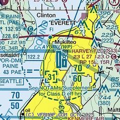
| Sectional chart |
|---|
|
CAUTION: Diagram may not be current
 Download PDF
of official airport diagram from the FAA
| Airport distance calculator |
|---|
|
|
| Sunrise and sunset |
|---|
|
Times for 23-Mar-2026
| | Local
(UTC-7) | | Zulu
(UTC) |
|---|
| Morning civil twilight | | 06:36 | | 13:36 |
| Sunrise | | 07:07 | | 14:07 |
| Sunset | | 19:25 | | 02:25 |
| Evening civil twilight | | 19:56 | | 02:56 |
|
| Current date and time |
|---|
| Zulu (UTC) | 23-Mar-2026 07:06:21 |
|---|
| Local (UTC-7) | 23-Mar-2026 00:06:21 |
|---|
|
| METAR |
|---|
| KPAE | 230653Z 34006KT 10SM CLR 05/01 A3021 RMK AO2 SLP235 T00500006
|
KAWO
16nm N | 230656Z AUTO 01005KT 10SM CLR 03/01 A3023 RMK AO2 SLP245 T00280006 401111006
|
|
| TAF |
|---|
| KPAE | 230520Z 2306/2406 33005KT P6SM SCT250 FM230900 34004KT P6SM BKN250 FM232000 33007KT P6SM BKN200 FM240300 VRB03KT P6SM BKN150
|
|
| NOTAMs |
|---|
NOTAMs are issued by the DoD/FAA and will open in a separate window not controlled by AirNav.
|
|


