FAA INFORMATION EFFECTIVE 14 MAY 2026
Location
| FAA Identifier: | PMZ |
| Lat/Long: | 35-48-38.8090N 076-45-30.1320W
35-48.646817N 076-45.502200W
35.8107803,-76.7583700
(estimated) |
| Elevation: | 36.3 ft. / 11.1 m (surveyed) |
| Variation: | 10W (2000) |
| From city: | 2 miles S of PLYMOUTH, NC |
| Time zone: | UTC -4 (UTC -5 during Standard Time) |
| Zip code: | 27962 |
Airport Operations
| Airport use: | Open to the public |
| Activation date: | 03/1978 |
| Control tower: | no |
| ARTCC: | WASHINGTON CENTER |
| FSS: | RALEIGH FLIGHT SERVICE STATION |
| NOTAMs facility: | RDU (NOTAM-D service available) |
| Attendance: | 0800-1700
FOR SVC AFTER HRS CALL 252-793-9801. |
| Wind indicator: | lighted |
| Segmented circle: | yes |
| Lights: | ACTVT REIL RWY 03 & 21; PAPI RWY 03 & 21; MIRL RWY 03/21 - CTAF. |
| Beacon: | white-green (lighted land airport)
Operates sunset to sunrise. |
Airport Communications
| CTAF/UNICOM: | 122.8 |
| CHERRY POINT APPROACH: | 119.35 |
| CHERRY POINT DEPARTURE: | 119.35 |
| WX AWOS-3 at EDE (16 nm NE): | 118.275 (252-482-0757) |
Nearby radio navigation aids
| VOR radial/distance | | VOR name | | Freq | | Var |
|---|
| ECGr234/39.0 | | ELIZABETH CITY VOR/DME | | 115.75 | | 07W |
| NDB name | | Hdg/Dist | | Freq | | Var | | ID |
|---|
| CHOCOWINITY | | 051/24.8 | | 388 | | 08W | | RNW | .-. -. .-- |
| ALWOOD | | 087/30.5 | | 230 | | 09W | | AQE | .- --.- . |
| WOODVILLE | | 229/35.1 | | 254 | | 10W | | LLW | .-.. .-.. .-- |
Airport Services
| Fuel available: | 100LL JET-A1+
100LL:24 HR SS FUELING WITH CC. |
| Parking: | tiedowns |
| Airframe service: | NONE |
| Powerplant service: | NONE |
| Bottled oxygen: | NONE |
| Bulk oxygen: | NONE |
Runway Information
Runway 3/21
| Dimensions: | 5500 x 75 ft. / 1676 x 23 m |
| Surface: | asphalt, in good condition |
| Weight bearing capacity: | | Single wheel: | 30.0 | | Double wheel: | 40.0 |
|
| Runway edge lights: | medium intensity |
| RUNWAY 3 | | RUNWAY 21 |
| Latitude: | 35-48.214307N | | 35-49.079320N |
| Longitude: | 076-45.668500W | | 076-45.335860W |
| Elevation: | 36.3 ft. | | 34.9 ft. |
| Traffic pattern: | left | | left |
| Runway heading: | 027 magnetic, 017 true | | 207 magnetic, 197 true |
| Markings: | nonprecision, in good condition | | nonprecision, in good condition |
| Visual slope indicator: | 2-light PAPI on left (4.00 degrees glide path) | | 2-light PAPI on left (4.00 degrees glide path) |
| Runway end identifier lights: | yes | | yes |
| Touchdown point: | yes, no lights | | yes, no lights |
| Obstructions: | 43 ft. trees, 514 ft. from runway, 256 ft. left of centerline, 1:1 slope to clear | | 32 ft. trees, 1257 ft. from runway, 26 ft. left of centerline, 33:1 slope to clear |
Airport Ownership and Management from official FAA records
| Ownership: | Publicly-owned |
| Owner: | WASHINGTON COUNTY
PO BOX 1007, 116 ADAMS STREET
PLYMOUTH, NC 27962
Phone 252-793-5823 |
| Manager: | MARY MQSCATO
1069 AIRPORT RD.
PLYMOUTH, NC 27962
Phone 252-793-9801 |
Additional Remarks
| - | CTN: ARPT LCTD 5 MI WEST OF MIL RSTRD AREA; HI PER MIL ACFT XNG ARPT BLW 3000 FT MSL ENRT TO RSTRD AREA - XNGS ARE UNANNCD. |
| - | DEER ACT ON & INVOF ARPT. |
| - | FOR CD CTC WASHINGTON ARTCC AT 703-771-3587. |
Instrument Procedures
NOTE: All procedures below are presented as PDF files. If you need a reader for these files, you should download the free Adobe Reader.NOT FOR NAVIGATION. Please procure official charts for flight.
FAA instrument procedures published for use from 14 May 2026 at 0901Z to 11 June 2026 at 0900Z.
IAPs - Instrument Approach Procedures |
|---|
| RNAV (GPS) RWY 03 | |
download (227KB) |
| RNAV (GPS) RWY 21 | |
download (224KB) |
| NOTE: Special Take-Off Minimums/Departure Procedures apply | |
download (141KB) |
Other nearby airports with instrument procedures:
KEDE - Northeastern Regional Airport (16 nm NE)
KOCW - Washington-Warren Airport (20 nm SW)
KMCZ - Martin County Airport (21 nm W)
KPGV - Pitt-Greenville Airport (32 nm W)
KASJ - Tri-County Airport at Henry Joyner Field (35 nm NW)
|
|

Road maps at:
MapQuest
Bing
Google
| Aerial photo |
|---|
WARNING: Photo may not be current or correct

Do you have a better or more recent aerial photo of Plymouth Municipal Airport that you would like to share? If so, please send us your photo.
|
| Sectional chart |
|---|
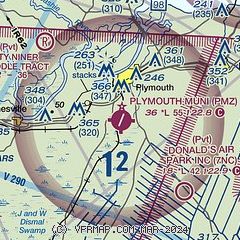
|
| Airport distance calculator |
|---|
|
|
| Sunrise and sunset |
|---|
|
Times for 06-Jun-2026
| | Local
(UTC-4) | | Zulu
(UTC) |
|---|
| Morning civil twilight | | 05:22 | | 09:22 |
| Sunrise | | 05:52 | | 09:52 |
| Sunset | | 20:20 | | 00:20 |
| Evening civil twilight | | 20:49 | | 00:49 |
|
| Current date and time |
|---|
| Zulu (UTC) | 07-Jun-2026 02:04:22 |
|---|
| Local (UTC-4) | 06-Jun-2026 22:04:22 |
|---|
|
| METAR |
|---|
KEDE
15nm NE | 070155Z AUTO 21012G16KT 10SM CLR 26/18 A2997 RMK AO2 T02640184
|
KOCW
20nm SW | 070135Z AUTO 18009KT 10SM CLR 26/16 A2998 RMK AO2 T02570162
|
KMCZ
21nm W | 070155Z AUTO 18006KT 10SM CLR 26/17 A2997 RMK AO2 T02600170
|
|
| TAF |
|---|
KPGV
33nm W | 061725Z 0618/0718 23010G20KT P6SM SCT250 FM070000 22009KT P6SM SCT250 FM071200 25009G14KT P6SM SCT250 AMD LTD TO CLD VIS AND WIND
|
KECG
39nm NE | 061720Z 0618/0718 23011KT P6SM BKN250 FM070100 20012G20KT P6SM FEW250 FM071200 24012KT P6SM FEW250
|
|
| NOTAMs |
|---|
NOTAMs are issued by the DoD/FAA and will open in a separate window not controlled by AirNav.
|
|

