FAA INFORMATION EFFECTIVE 16 APRIL 2026
Location
| FAA Identifier: | WAY |
| Lat/Long: | 39-54-04.1000N 080-07-50.5000W
39-54.068333N 080-07.841667W
39.9011389,-80.1306944
(estimated) |
| Elevation: | 1068.6 ft. / 325.7 m (surveyed) |
| Variation: | 09W (2010) |
| From city: | 2 miles E of WAYNESBURG, PA |
| Time zone: | UTC -4 (UTC -5 during Standard Time) |
| Zip code: | 15370 |
Airport Operations
| Airport use: | Open to the public |
| Activation date: | 12/1937 |
| Control tower: | no |
| ARTCC: | CLEVELAND CENTER |
| FSS: | ALTOONA FLIGHT SERVICE STATION |
| NOTAMs facility: | AOO (NOTAM-D service available) |
| Attendance: | UNATNDD
FOR SVC AFT HOURS CTC 724-993-2190. |
| Wind indicator: | yes |
| Segmented circle: | yes |
Airport Communications
| CTAF/UNICOM: | 122.8 |
| CLARKSBURG APPROACH: | 121.15 |
| CLARKSBURG DEPARTURE: | 121.15 |
| WX AWOS-3PT at AFJ (16 nm NW): | 119.175 (724-228-3529) |
| WX ASOS at MGW (18 nm SE): | 120.675 (304-371-2021) |
- APCH/DEP SVC PRVDD BY CLEVELAND ARTCC ON FREQS 126.950/239.3 (BELMONT RCAG) WHEN CLARKSBURG APCH CLSD.
Nearby radio navigation aids
| VOR radial/distance | | VOR name | | Freq | | Var |
|---|
| AGCr199/23.0 | | ALLEGHENY VOR/DME | | 110.00 | | 09W |
| MGWr334/24.1 | | MORGANTOWN VOR/DME | | 111.60 | | 05W |
| HLGr144/29.5 | | WHEELING VOR/DME | | 114.25 | | 07W |
| AIRr109/32.3 | | BELLAIRE VOR/DME | | 117.10 | | 07W |
| CKBr013/39.4 | | CLARKSBURG VOR/DME | | 112.60 | | 04W |
Airport Services
| Fuel available: | 100LL |
| Parking: | hangars and tiedowns |
| Airframe service: | MAJOR |
| Powerplant service: | MAJOR |
| Bottled oxygen: | NONE |
Runway Information
Runway 9/27
| Dimensions: | 3500 x 75 ft. / 1067 x 23 m |
| Surface: | asphalt, in fair condition |
| Weight bearing capacity: | |
| Runway edge markings: | RWY NRS AND CL MRKGS IN POOR COND. |
| RUNWAY 9 | | RUNWAY 27 |
| Latitude: | 39-54.013167N | | 39-54.124667N |
| Longitude: | 080-08.209167W | | 080-07.475000W |
| Elevation: | 1064.9 ft. | | 1062.1 ft. |
| Traffic pattern: | left | | left |
| Markings: | basic, in poor condition | | basic, in poor condition |
| Touchdown point: | yes, no lights | | yes, no lights |
| Obstructions: | 17 ft. trees, 257 ft. from runway, 116 ft. left of centerline, 3:1 slope to clear
15 FT TREES, 128 FT FM RWY END, 166 FT R; 19 FT TREES, 95 FT FM RWY END 180 FT L. | | 28 ft. trees, 285 ft. from runway, 84 ft. right of centerline, 3:1 slope to clear |
Airport Ownership and Management from official FAA records
| Ownership: | Publicly-owned |
| Owner: | GREENE COUNTY
COUNTY OFFICE BLDG
WAYNESBURG, PA 15370
Phone 724-852-5323 |
| Manager: | MARIO BARCHIESI
107 FAIRGROUNDS RD
WAYNESBURG, PA 15370
Phone 724-998-5042 |
Additional Remarks
| - | GROUND DROPS OFF SHARPLY EAST END RY 09/27. |
| - | DEER AND BIRDS ON & INVOF RY. |
| - | 290 FT HIGH TERRAIN 1,900 FT SOUTH OF RY. |
| - | FOR CD CTC CLARKSBURG APCH AT 304-842-2011, WHEN APCH CLSD CTC CLEVELAND ARTCC AT 440-774-0226. |
| - | EXTSV GLIDER OPS WKENDS. |
| - | DALGT OPNS ONLY. |
Instrument Procedures
NOTE: All procedures below are presented as PDF files. If you need a reader for these files, you should download the free Adobe Reader.NOT FOR NAVIGATION. Please procure official charts for flight.
FAA instrument procedures published for use from 16 April 2026 at 0901Z to 14 May 2026 at 0900Z.
IAPs - Instrument Approach Procedures |
|---|
| RNAV (GPS) RWY 27 | |
download (176KB) |
| RNAV (GPS) Z RWY 09 | |
download (188KB) |
| COPTER RNAV (GPS) Y RWY 09 | |
download (166KB) |
| NOTE: Special Take-Off Minimums/Departure Procedures apply | |
download (149KB) |
Other nearby airports with instrument procedures:
KAFJ - Washington County Airport (16 nm NW)
KMGW - Morgantown Municipal Airport/Walter L Bill Hart Field (18 nm SE)
G05 - Finleyville Airpark (21 nm N)
KVVS - Joseph A Hardy Connellsville Airport (22 nm E)
KFWQ - Rostraver Airport (23 nm NE)
|
|

Road maps at:
MapQuest
Bing
Google
| Aerial photo |
|---|
WARNING: Photo may not be current or correct
 Photo by Brittney Menear
Photo taken 18-Apr-2017
looking southwest.
Photo by Brittney Menear
Photo taken 18-Apr-2017
looking southwest.
Do you have a better or more recent aerial photo of Greene County Airport that you would like to share? If so, please send us your photo.
|
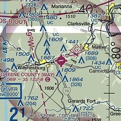
| Sectional chart |
|---|
|
| Airport distance calculator |
|---|
|
|
| Sunrise and sunset |
|---|
|
Times for 13-May-2026
| | Local
(UTC-4) | | Zulu
(UTC) |
|---|
| Morning civil twilight | | 05:38 | | 09:38 |
| Sunrise | | 06:08 | | 10:08 |
| Sunset | | 20:25 | | 00:25 |
| Evening civil twilight | | 20:56 | | 00:56 |
|
| Current date and time |
|---|
| Zulu (UTC) | 13-May-2026 21:17:47 |
|---|
| Local (UTC-4) | 13-May-2026 17:17:47 |
|---|
|
| METAR |
|---|
KAFJ
14nm NW | 132056Z AUTO 30011G23KT 10SM FEW044 SCT065 BKN090 18/10 A2977 RMK AO2 LTG DSNT E TSE02RAE09 SLP076 P0000 60024 T01780100 55005 $
|
KMGW
18nm SE | 132103Z 19009G15KT 10SM VCTS BKN065 BKN080 OVC095 13/11 A2980 RMK AO2 LTG DSNT NE-S TSE2057 PRESRR LTGCG TS SW MOV E T01280111
|
KVVS
22nm E | 132055Z AUTO 33005G20KT 10SM SCT044 SCT060 BKN070 17/08 A2976 RMK AO2 T01700085
|
KP53
23nm NE | 132056Z AUTO 32016G25KT 08/02 A2999 RMK AO1 PK WND 33026/2009 SLP161 T00780017 50001 $
|
KAGC
29nm N | 132053Z 22008KT 9SM -RA FEW043 SCT060 OVC090 15/11 A2973 RMK AO2 LTG DSNT NE-SE RAB52 SLP071 P0000 60003 T01500106 55003
|
KHLG
29nm NW | 132053Z 29013G28KT 10SM SCT060 SCT070 BKN090 18/06 A2975 RMK AO2 PK WND 29034/2007 SLP074 60007 T01780056 53002
|
|
| TAF |
|---|
KMGW
18nm SE | 131720Z 1318/1418 23012G20KT P6SM BKN035 FM132000 25012G20KT 5SM -SHRA BKN035 TEMPO 1320/1324 VRB20G35KT 3SM -TSRA BKN035CB FM140000 33006KT P6SM BKN035 FM140600 30005KT P6SM VCSH OVC020 FM141400 30009G17KT P6SM VCSH BKN020
|
|
| NOTAMs |
|---|
NOTAMs are issued by the DoD/FAA and will open in a separate window not controlled by AirNav.
|
|

