FAA INFORMATION EFFECTIVE 17 APRIL 2025
Location
| FAA Identifier: | MMU |
| Lat/Long: | 40-47-57.6180N 074-24-53.5990W
40-47.960300N 074-24.893317W
40.7993383,-74.4148886
(estimated) |
| Elevation: | 186.6 ft. / 56.9 m (surveyed) |
| Variation: | 13W (2005) |
| From city: | 3 miles E of MORRISTOWN, NJ |
| Time zone: | UTC -4 (UTC -5 during Standard Time) |
| Zip code: | 07960 |
Airport Operations
| Airport use: | Open to the public |
| Activation date: | 05/1943 |
| Control tower: | yes |
| ARTCC: | NEW YORK CENTER |
| FSS: | MILLVILLE FLIGHT SERVICE STATION |
| NOTAMs facility: | MMU (NOTAM-D service available) |
| Attendance: | 0645-2230 |
| Pattern altitude: | TPA 1013 LIGHT ACFT, 1513 HEAVY ACFT. |
| Wind indicator: | lighted |
| Segmented circle: | yes |
| Lights: | DUSK-DAWN; ACTVT HIRL RWY 05/23, MIRL RW 13/31, REIL RWY 05 & 31, MALSR RWY 23 & PAPI RWY 31 - CTAF. |
| Beacon: | white-green (lighted land airport)
Operates sunset to sunrise. |
| Landing fee: | yes |
| International operations: | US CUSTOMS USER FEE ARPT. |
Airport Communications
| CTAF: | 118.1 |
| ATIS: | 124.25 |
| WX AWOS-3: | PHONE 973-290-0135 |
| MORRISTOWN GROUND: | 134.2 [0645-2230] |
| MORRISTOWN TOWER: | 118.1 353.9 [0645-2230] |
| NEWARK APPROACH: | 127.6 |
| NEWARK DEPARTURE: | 119.2 |
| CLEARANCE DELIVERY: | 128.6 |
| EMERG: | 121.5 243.0 |
| JAIKE STAR: | 132.8 |
| WILKES-BARRE STAR: | 127.6 |
| WX ASOS at CDW (8 nm NE): | 135.5 (973-575-4417) |
| WX ASOS at EWR (13 nm SE): | PHONE 973-621-2892 |
| WX AWOS-3 at LDJ (13 nm SE): | 124.025 (908-862-7383) |
| WX ASOS at SMQ (16 nm SW): | 120.6 (908-722-2139) |
| WX ASOS at TEB (16 nm E): | PHONE 201-426-9519 |
| WX ASOS at 12N (19 nm NW): | PHONE 609-325-2295 |
| WX AWOS-3PT at JRB (19 nm E): | 128.175 (212-425-1534) |
- CALL 516-542-3690 WHEN TWR CLSD.
Nearby radio navigation aids
| VOR radial/distance | | VOR name | | Freq | | Var |
|---|
| TEBr271/16.3 | | TETERBORO VOR/DME | | 108.40 | | 11W |
| SAXr172/17.0 | | SPARTA VORTAC | | 115.70 | | 11W |
| BWZr101/18.5 | | BROADWAY VOR/DME | | 114.20 | | 11W |
| SBJr059/19.7 | | SOLBERG VOR/DME | | 112.90 | | 10W |
| STWr131/23.7 | | STILLWATER VOR/DME | | 109.60 | | 11W |
| LGAr284/24.8 | | LA GUARDIA VOR/DME | | 113.10 | | 12W |
| CRIr306/26.2 | | CANARSIE VOR/DME | | 112.30 | | 11W |
| JFKr301/30.9 | | KENNEDY VOR/DME | | 115.90 | | 12W |
| COLr349/31.5 | | COLTS NECK VOR/DME | | 115.40 | | 11W |
| RBVr016/36.0 | | ROBBINSVILLE VORTAC | | 113.80 | | 10W |
| HUOr179/37.5 | | HUGUENOT VOR/DME | | 116.10 | | 11W |
| ARDr044/39.7 | | YARDLEY VOR/DME | | 108.20 | | 10W |
Airport Services
| Fuel available: | 100LL JET-A JET-A+
A:O-128 AVOIL AVBL. |
| Oil available: | WHEN TWR CLSD ALL ACFT AND VEHICLES MUST STATE INTNS ON CTAF BFR OPS ON ANY RWY. |
| Parking: | hangars and tiedowns |
| Airframe service: | NONE |
| Powerplant service: | NONE |
| Bottled oxygen: | HIGH/LOW |
| Bulk oxygen: | HIGH/LOW |
Runway Information
Runway 5/23
| Dimensions: | 5998 x 150 ft. / 1828 x 46 m |
| Surface: | asphalt/grooved, in good condition |
| Weight bearing capacity: | | PCN 25 /F/C/X/T | | Single wheel: | 30.0 | | Double wheel: | 80.0 |
|
| Runway edge lights: | high intensity |
| RUNWAY 5 | | RUNWAY 23 |
| Latitude: | 40-47.586242N | | 40-48.384327N |
| Longitude: | 074-25.154512W | | 074-24.388465W |
| Elevation: | 181.8 ft. | | 182.8 ft. |
| Traffic pattern: | left | | left |
| Runway heading: | 049 magnetic, 036 true | | 229 magnetic, 216 true |
| Markings: | precision, in good condition | | precision, in good condition |
| Approach lights: | | | MALSR: 1,400 foot medium intensity approach lighting system with runway alignment indicator lights |
| Runway end identifier lights: | yes | | |
| Touchdown point: | yes, no lights | | yes, no lights |
| Instrument approach: | | | ILS |
| Obstructions: | 102 ft. trees, 2100 ft. from runway, 18:1 slope to clear | | none |
Runway 13/31
| Dimensions: | 3997 x 150 ft. / 1218 x 46 m |
| Surface: | asphalt/grooved, in good condition |
| Weight bearing capacity: | | PCN 11 /F/C/X/T | | Single wheel: | 30.0 |
|
| Runway edge lights: | medium intensity |
| RUNWAY 13 | | RUNWAY 31 |
| Latitude: | 40-48.056303N | | 40-47.789262N |
| Longitude: | 074-25.471980W | | 074-24.680185W |
| Elevation: | 186.5 ft. | | 181.3 ft. |
| Traffic pattern: | left | | left |
| Runway heading: | 127 magnetic, 114 true | | 307 magnetic, 294 true |
| Markings: | basic, in good condition | | basic, in good condition |
| Visual slope indicator: | | | 2-light PAPI on left (3.50 degrees glide path) |
| Runway end identifier lights: | | | yes |
| Touchdown point: | yes, no lights | | yes, no lights |
| Obstructions: | 49 ft. trees, 320 ft. from runway, 240 ft. right of centerline, 2:1 slope to clear | | 91 ft. trees, 1690 ft. from runway, 330 ft. left of centerline, 16:1 slope to clear |
Airport Ownership and Management from official FAA records
| Ownership: | Publicly-owned |
| Owner: | TOWN OF MORRISTOWN
110 SOUTH STREET
MORRISTOWN, NJ 07960
Phone 973-292-6626 |
| Manager: | SCOTT MCMAHON
DM AIRPORTS, LTD., 8 AIRPORT ROAD
MORRISTOWN, NJ 07960
Phone 973-538-6400 |
Additional Remarks
| - | BIRDS & DEER ON & INVOF ARPT. |
| - | ARFF SVCS AVBL 24 HRS DAILY. FOR ARFF SVCS WHEN ATCT CLSD CTC ARFF STATION; CTAF OR 973-455-1953. |
| - | ALL ARRIVAL/DEPARTURE ACFT FOLLOW MANUFACTURERS RECOMMENDED PROCEDURES FOR QUIET OPNS & MINIMUM NOISE. |
| - | ROUTE 80 VISUAL APCH PREFERRED FOR RY 23. |
| - | HELICOPTER OPNS OVER RESIDENTIAL AREAS BLO 1000 FT MSL SHOULD BE AVOIDED. |
| - | STAGE I DEPARTURE FEE 2300-0645. |
| - | DURG SNOW REMOVAL OPNS 15 MINUTE PRIOR NOTICE REQUIRED ON 118.1 & NO PRACTICE LOW APCHS OR TOUCH & GO LDGS. |
| - | INBOUND TFC REQUEST FBO SVCS, INSTRUCTIONS & RAMP ADVISORIES 30 MINUTES PRIOR TO ARRIVAL. AFTER LDG CTC FBO AGAIN 129.6 FOR PREFERRED RAMP ENTRANCE TO DELTA OR JULIET TWYS. |
| - | TAXILANE K N OF LYNX FBO RAMP, NO HEL OR ACFT WITH A WINGSPAN GTR THAN 50 FT. |
| - | VOLUNTARY NOISE ABATEMENT PROC INCLUDE AVOIDING TGL OPS ON RWY 13-31. |
| - | NOISE ABATEMENT PROC IN EFCT; CTC NOISE ABATEMENT OFFICE 973-538-3366 EXTN 122. |
| - | FOR CD WHEN ATCT IS CLSD CTC NEWARK APCH AT 800-645-3206. |
| - | NO TGL ON RWY 13/31 UNLESS THE CROSSWIND VLCTY FOR RWY 05/23 EXCEEDS 10 KTS. |
| - | US CUSTOMS AVBL MON-FRI 0800-1600; BTN 1601-0759 & WKENDS CALL 973-267-0302 FOR APPOINTMENT. MORRISTOWN CUSTOMS ASSOCIATION FEES APPLY; CTC AMGR 973-538-6400 FOR DETAILS. |
| - | NO TURBOJET LNDG ON RWY 13 & 31 UNLESS THE X-WIND VELOCITY FOR RWY 5/23 EXCEEDS 16 KNOTS. |
| - | ACFT CARRYING EXPLOSIVE CARGO PPR BEFORE LDG - CALL 973-538-6400. |
| - | FLIGHT NOTIFICATION SVC (ADCUS) AVBL. |
| - | U.S. CUSTOMS USER FEE ARPT. |
Instrument Procedures
NOTE: All procedures below are presented as PDF files. If you need a reader for these files, you should download the free Adobe Reader.NOT FOR NAVIGATION. Please procure official charts for flight.
FAA instrument procedures published for use from 17 April 2025 at 0901Z to 15 May 2025 at 0900z.
STARs - Standard Terminal Arrivals |
|---|
| JAIKE FOUR (RNAV) | |
2 pages:
[1] [2] (367KB) |
| MAZIE THREE (RNAV) | |
download (200KB) |
| WILKES-BARRE FIVE | |
download (182KB) |
IAPs - Instrument Approach Procedures |
|---|
| ILS OR LOC RWY 23 | |
download (257KB) |
| RNAV (RNP) Y RWY 23 | |
download (264KB) |
| RNAV (GPS) RWY 05 | |
download (229KB) |
| RNAV (GPS) Z RWY 23 | |
download (237KB) |
| ROUTE 80 VISUAL RWY 23 | |
download (220KB) |
| NOTE: Special Alternate Minimums apply | |
download (106KB) |
Departure Procedures |
|---|
| MORRISTOWN SEVEN | |
2 pages:
[1] [2] (523KB) |
| NOTE: Special Take-Off Minimums/Departure Procedures apply | |
download (530KB) |
Other nearby airports with instrument procedures:
KCDW - Essex County Airport (8 nm NE)
N07 - Lincoln Park Airport (10 nm NE)
KEWR - Newark Liberty International Airport (13 nm SE)
KLDJ - Linden Airport (13 nm SE)
KSMQ - Somerset Airport (16 nm SW)
KTEB - Teterboro Airport (16 nm E)
47N - Central Jersey Regional Airport (18 nm SW)
KJRA - West 30th St Heliport (19 nm E)
12N - Aeroflex/Andover Airport (19 nm NW)
KJRB - Downtown Manhattan/Wall Street Heliport (19 nm E)
|
|

Road maps at:
MapQuest
Bing
Google
| Aerial photo |
|---|
WARNING: Photo may not be current or correct
 Photo taken 19-Dec-2019
looking east.
Photo taken 19-Dec-2019
looking east.
Do you have a better or more recent aerial photo of Morristown Municipal Airport that you would like to share? If so, please send us your photo.
|
| Sectional chart |
|---|
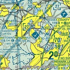
|
CAUTION: Diagram may not be current
 Download PDF
of official airport diagram from the FAA
| Airport distance calculator |
|---|
|
|
| Sunrise and sunset |
|---|
|
Times for 18-Apr-2025
| | Local
(UTC-4) | | Zulu
(UTC) |
|---|
| Morning civil twilight | | 05:47 | | 09:47 |
| Sunrise | | 06:15 | | 10:15 |
| Sunset | | 19:39 | | 23:39 |
| Evening civil twilight | | 20:07 | | 00:07 |
|
| Current date and time |
|---|
| Zulu (UTC) | 18-Apr-2025 18:02:01 |
|---|
| Local (UTC-4) | 18-Apr-2025 14:02:01 |
|---|
|
| METAR |
|---|
| KMMU | 181745Z 22014G20KT 10SM SCT250 22/04 A3016
|
KCDW
8nm NE | 181753Z 20010G20KT 10SM CLR 22/02 A3015 RMK AO2 SLP216 T02170022 10222 20056 58033
|
KEWR
13nm SE | 181751Z 14011G17KT 10SM FEW150 FEW200 BKN250 21/03 A3016 RMK AO2 SLP214 T02060028 10206 20100 58031
|
KLDJ
13nm SE | 181755Z AUTO 23005KT 10SM 23/01 A3016 RMK AO2 T02280009 10228 20081
|
KSMQ
16nm SW | ASOS 120.60 908-722-2139
181753Z AUTO 19010G19KT 10SM CLR 23/05 A3013 RMK AO2 SLP204 T02330050 10233 20033 58033
|
KTEB
17nm E | 181751Z 13013G19KT 10SM CLR 19/02 A3016 RMK AO2 SLP212 T01940017 10200 20078 58031
|
KJRB
19nm E | 181756Z AUTO 17008G18KT 10SM CLR 18/03 A3020 RMK AO2 SLP225 6//// T01780033 10178 20089 58028 PNO $
|
K12N
19nm NW | 181754Z AUTO 21013G22KT 20/04 A3012 RMK AO1 PK WND 21026/1733 SLP202 T02000039 10217 20033 58031
|
|
| TAF |
|---|
KEWR
13nm SE | 181729Z 1818/1924 12011KT P6SM SCT250 FM181900 18013G22KT P6SM SCT120 BKN250 FM190100 19010KT P6SM SCT120 BKN200 WS020/23045KT FM190800 21008KT P6SM SCT060 BKN200 WS020/23045KT FM191400 24015G26KT P6SM SCT060 BKN250 PROB30 1922/1924 -SHRA BKN060
|
KTEB
17nm E | 181729Z 1818/1924 18012G22KT P6SM SCT120 BKN250 FM190100 18010KT P6SM SCT120 BKN200 WS020/23045KT FM190800 18006KT P6SM SCT060 BKN200 WS020/23045KT FM191400 24014G26KT P6SM SCT060 BKN250 PROB30 1922/1924 -SHRA BKN060
|
|
| NOTAMs |
|---|
NOTAMs are issued by the DoD/FAA and will open in a separate window not controlled by AirNav.
|
|


