FAA INFORMATION EFFECTIVE 17 APRIL 2025
Location
| FAA Identifier: | MTN |
| Lat/Long: | 39-19-32.3810N 076-24-49.5220W
39-19.539683N 076-24.825367W
39.3256614,-76.4137561
(estimated) |
| Elevation: | 21.5 ft. / 6.6 m (surveyed) |
| Variation: | 11W (2000) |
| From city: | 9 miles E of BALTIMORE, MD |
| Time zone: | UTC -4 (UTC -5 during Standard Time) |
| Zip code: | 21220 |
Airport Operations
| Airport use: | Open to the public |
| Activation date: | 04/1940 |
| Control tower: | yes |
| ARTCC: | WASHINGTON CENTER |
| FSS: | LEESBURG FLIGHT SERVICE STATION |
| NOTAMs facility: | MTN (NOTAM-D service available) |
| Attendance: | 0600-2100 |
| Pattern altitude: | TPA RECIPROCATING ENG ACFT 978 FT AGL; TURBOPROP & CIVIL JET ACFT 1478 FT AGL; MIL JET ACFT 1978 FT AGL. |
| Wind indicator: | lighted |
| Segmented circle: | no |
| Lights: | DUSK-DAWN. WHEN ATCT CLSD ACTVT REIL RWYS 15 & 33; HIRL RWY 15/33 - CTAF. WHEN ATCT CLSD ACTVT TWY F LGTS - UNICOM. |
| Beacon: | white-green (lighted land airport)
Operates sunset to sunrise. |
| International operations: | customs landing rights airport |
Airport Communications
| CTAF: | 121.3 |
| UNICOM: | 122.95 |
| ATIS: | 124.925 |
| WX AWOS-3PT: | 124.925 (410-682-8848) |
| MARTIN GROUND: | 121.8 253.4 [0600-2200] |
| MARTIN TOWER: | 121.3 254.425 [0600-2200] |
| POTOMAC APPROACH: | 119.0 119.7 |
| POTOMAC DEPARTURE: | 119.0 119.7 |
| ANTHM STAR: | 133.85 |
| COMD POST: | 139.6 ;175 WG 275.7 ;175 WG |
| EMERG: | 121.5 243.0 |
| MIIDY STAR: | 133.75 |
| RAVNN STAR: | 128.35 |
| TERPZ DP: | 119.7 |
| TRISH STAR: | 125.525 |
| WESTMINSTER STAR: | 126.825 ;10000 FT & BLW 133.85 ;11000 FT & ABV |
| WX ASOS at BWI (15 nm SW): | PHONE 227-217-0474 |
| WX AWOS-3PT at 0W3 (18 nm NE): | 132.725 (667-340-6003) |
- ATIS FREQ 124.925 USED TO TMT AWOS WX DATA WHEN ATCT CLOSES.
Nearby radio navigation aids
| VOR radial/distance | | VOR name | | Freq | | Var |
|---|
| BALr062/14.8 | | BALTIMORE VORTAC | | 115.10 | | 11W |
| EMIr119/28.1 | | WESTMINSTER VORTAC | | 117.90 | | 08W |
| ADWr044/37.6 | | ANDREWS VORTAC | | 113.10 | | 10W |
| NDB name | | Hdg/Dist | | Freq | | Var | | ID |
|---|
| ELLICOTT | | 093/17.0 | | 371 | | 11W | | FND | ..-. -. -.. |
Airport Services
| Fuel available: | 100LL JET-A+
100LL:24 HR SELF SERVE 100LL AVBL WITH CREDIT CARD. HELIS NOT AUTH TO ACES THE 100-LL SELF SVC STN UNDER OWN PWR. |
| Parking: | hangars and tiedowns |
| Airframe service: | MINOR |
| Powerplant service: | MINOR |
| Bottled oxygen: | NONE |
| Bulk oxygen: | NONE |
Runway Information
Runway 15/33
| Dimensions: | 6997 x 180 ft. / 2133 x 55 m |
| Surface: | asphalt/grooved, in excellent condition |
| Weight bearing capacity: | | Single wheel: | 65.0 | | Double wheel: | 82.0 | | Double tandem: | 140.0 |
|
| Runway edge lights: | high intensity |
| Operational restrictions: | 8100 FT AVBL FOR TKOF RWY 15 AND LNDG RWY 33 FOR MIL ACFT ONLY. |
| RUNWAY 15 | | RUNWAY 33 |
| Latitude: | 39-19.948418N | | 39-19.130918N |
| Longitude: | 076-25.348985W | | 076-24.302845W |
| Elevation: | 21.3 ft. | | 9.2 ft. |
| Traffic pattern: | left | | left |
| Runway heading: | 146 magnetic, 135 true | | 326 magnetic, 315 true |
| Markings: | nonprecision, in good condition | | precision, in good condition |
| Visual slope indicator: | pulsating/steady burning VASI on left (4.01 degrees glide path)
UNUSBL BYD 5 DEGS EITHER SIDE OF CENTERLINE. | | pulsating/steady burning VASI on left (2.91 degrees glide path) |
| Runway end identifier lights: | yes | | yes |
| Touchdown point: | yes, no lights | | yes, no lights |
| Instrument approach: | LOC/DME | | ILS/DME |
| Obstructions: | 84 ft. trees, 2223 ft. from runway, 116 ft. left of centerline, 24:1 slope to clear
BOAT MAST | | 64 ft. trees, 3285 ft. from runway, 57 ft. right of centerline, 48:1 slope to clear |
Helipad H1
| Dimensions: | 60 x 60 ft. / 18 x 18 m |
| Surface: | concrete |
| Latitude: | 39-19.595167N | | |
| Longitude: | 076-25.217667W | | |
| Elevation: | 15.0 ft. | | |
| Traffic pattern: | left | | left |
Airport Ownership and Management from official FAA records
| Ownership: | Publicly-owned |
| Owner: | MAA
BOX 1 701 WILSON PT RD
BALTIMORE, MD 21220
Phone 410-682-8800
MARYLAND AVN ADMIN. |
| Manager: | HAROLD A. FOWLER
BOX 1, 701 WILSON POINT RD
BALTIMORE, MD 21220
Phone 410-682-8800 |
Additional Remarks
| - | NOISE ABATEMENT PROCS IN EFCT. WHEN ATCT CLSD NO PRACTICE LNDGS OR APCHS. |
| - | BEARING STRENGTH RWY 15/33: ST175. |
| - | MILITARY: CAUTION: BASH II IN EFFECT AUG-JAN. |
| - | MILITARY: ANG: CALL COMD POST/RAVEN OPS 275.500 OR 139.900 10 MIN PRIOR TO LNDG. NO SPACE A, FLEET SVC, OR TRAN QTRS AVBL. PPR AFTER DUTY HR RQR OG/CC APVL. C-5/C-17 ACFT RSTRD TO TWY A. PPR FOR SVC AND USE OF ANG PRK RAMP ONLY, DSN 243-6630/6637/6444, C410-918-6630/6637/6444; AFTER DUTY HR CTC C443-421-3128. |
| - | FOR CD WHEN TWR CLSD CTC POTOMAC APCH AT 866-429-5882. |
| - | ARFF SVCS AVBL 24 HRS DAILY. FOR ARFF SVCS WHEN ATCT CLSD CTC ARFF STATION; CTAF OR 410-918-6257 / 410-918-6911. |
| - | NO ACFT ACCESS TO TWY S FM STRAWBERRY POINT RAMP. |
| - | SEAGULLS ON & INVOF ARPT. |
| - | ARPT CONDS UNMON 2300-0600. |
| - | MOWING OPS CONDUCTED DURG DALGT. |
| - | PPR FOR PRACTICE TKOFS & LNDGS FOR ACFT WEIGHING MORE THAN 12500 LBS. |
| - | RECREATIONAL SAILBOAT MASTS TO +50 FT & MOTOR BOATS IN WATERWAY AT AER 33 813 FT FM THR ON CNTRLN. |
| - | FOR ADDL INFO CTC AMGR 410-682-8800. |
Instrument Procedures
NOTE: All procedures below are presented as PDF files. If you need a reader for these files, you should download the free Adobe Reader.NOT FOR NAVIGATION. Please procure official charts for flight.
FAA instrument procedures published for use from 17 April 2025 at 0901Z to 15 May 2025 at 0900z.
STARs - Standard Terminal Arrivals |
|---|
| ANTHM FIVE (RNAV) | |
2 pages:
[1] [2] (368KB) |
| ANTHM FIVE (RNAV) | |
2 pages:
[1] [2] (368KB) |
| ANTHM FIVE (RNAV), CONT.2 | |
download (310KB) |
| ANTHM FIVE (RNAV), CONT.2 | |
download (310KB) |
| MIIDY THREE (RNAV) | |
2 pages:
[1] [2] (452KB) |
| RAVNN EIGHT (RNAV) **NEW** | |
2 pages:
[1] [2] (457KB) |
| RAVNN EIGHT (RNAV), CONT.2 **NEW** | |
download (319KB) |
| TRISH FOUR (RNAV) | |
2 pages:
[1] [2] (479KB) |
| WESTMINSTER SEVEN | |
download (255KB) |
IAPs - Instrument Approach Procedures |
|---|
| ILS OR LOC RWY 33 | |
download (345KB) |
| RNAV (GPS) RWY 15 | |
download (284KB) |
| RNAV (GPS) RWY 33 | |
download (333KB) |
| LOC RWY 15 | |
download (363KB) |
| VOR OR TACAN RWY 15 | |
download (274KB) |
| NOTE: Special Alternate Minimums apply | |
download (167KB) |
Departure Procedures |
|---|
| CONLE FIVE (RNAV) | |
download (166KB) |
| FOXHL ONE (RNAV) | |
download (144KB) |
| LINSE TWO (RNAV) **NEW** | |
download (152KB) |
| TERPZ EIGHT (RNAV) | |
2 pages:
[1] [2] (288KB) |
| NOTE: Special Take-Off Minimums/Departure Procedures apply | |
download (213KB) |
Other nearby airports with instrument procedures:
KEDG - Weide Army Heliport (Aberdeen Proving Ground) (7 nm NE)
KAPG - Phillips Army Airfield (14 nm NE)
KBWI - Baltimore/Washington International Thurgood Marshall Airport (15 nm SW)
0W3 - Harford County Airport (18 nm NE)
W29 - Bay Bridge Airport (21 nm S)
|
|

Road maps at:
MapQuest
Bing
Google
| Aerial photo |
|---|
WARNING: Photo may not be current or correct
 Photo taken 14-Oct-2016
looking northeast.
Photo taken 14-Oct-2016
looking northeast.
Do you have a better or more recent aerial photo of Martin State Airport that you would like to share? If so, please send us your photo.
|
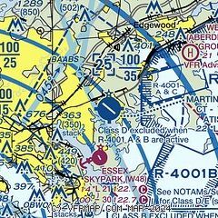
| Sectional chart |
|---|
|
CAUTION: Diagram may not be current
 Download PDF
of official airport diagram from the FAA
| Airport distance calculator |
|---|
|
|
| Sunrise and sunset |
|---|
|
Times for 17-Apr-2025
| | Local
(UTC-4) | | Zulu
(UTC) |
|---|
| Morning civil twilight | | 05:59 | | 09:59 |
| Sunrise | | 06:27 | | 10:27 |
| Sunset | | 19:44 | | 23:44 |
| Evening civil twilight | | 20:12 | | 00:12 |
|
| Current date and time |
|---|
| Zulu (UTC) | 17-Apr-2025 12:21:21 |
|---|
| Local (UTC-4) | 17-Apr-2025 08:21:21 |
|---|
|
| METAR |
|---|
| KMTN | 171154Z 00000KT 10SM CLR 06/00 A3024
|
KDMH
10nm W | 171153Z AUTO 08/M04 A3022 RMK AO1 SLP233 T00831044 10094 20067 53020
|
KBWI
16nm SW | 171154Z 00000KT 10SM CLR 07/M02 A3022 RMK AO2 SLP233 T00721022 10072 20022 53021
|
KAPG
18nm NE | 171155Z 21003KT 10SM CLR 05/00 A3022 RMK AO2A SLP236 T00491003 10061 20002 52023 $
|
|
| TAF |
|---|
| KMTN | 171124Z 1712/1812 VRB04KT P6SM SKC
|
KBWI
16nm SW | 171124Z 1712/1818 30005KT P6SM SKC FM171400 31007KT P6SM SKC FM180000 25003KT P6SM FEW250 FM181300 18008KT P6SM FEW190 FM181600 18014G23KT P6SM SCT190
|
|
| NOTAMs |
|---|
NOTAMs are issued by the DoD/FAA and will open in a separate window not controlled by AirNav.
|
|


