FAA INFORMATION EFFECTIVE 15 MAY 2025
Location
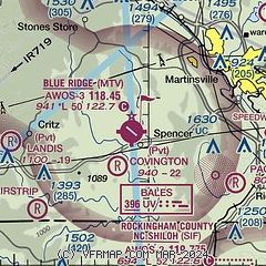
| FAA Identifier: | MTV |
| Lat/Long: | 36-37-50.7090N 080-01-06.0180W
36-37.845150N 080-01.100300W
36.6307525,-80.0183383
(estimated) |
| Elevation: | 940.9 ft. / 286.8 m (surveyed) |
| Variation: | 07W (1995) |
| From city: | 8 miles SW of MARTINSVILLE, VA |
| Time zone: | UTC -4 (UTC -5 during Standard Time) |
| Zip code: | 24055 |
Airport Operations
| Airport use: | Open to the public |
| Control tower: | no |
| ARTCC: | ATLANTA CENTER |
| FSS: | LEESBURG FLIGHT SERVICE STATION |
| NOTAMs facility: | MTV (NOTAM-D service available) |
| Attendance: | 0800-1700 |
| Wind indicator: | lighted |
| Segmented circle: | yes |
| Lights: | ACTVT REIL RWY 13 & 31; ODALS RWY 31; PAPI RWY 13 & 31; MIRL RWY 13/31 - CTAF. |
| Beacon: | white-green (lighted land airport)
Operates sunset to sunrise. |
Airport Communications
| CTAF/UNICOM: | 122.7 |
| WX AWOS-3: | 118.45 (276-957-3784) |
| GREENSBORO APPROACH: | 124.35 |
| GREENSBORO DEPARTURE: | 124.35 |
| CLEARANCE DELIVERY: | 124.85 |
| WX AWOS-3 at SIF (14 nm SE): | 119.775 (336-573-3677) |
Nearby radio navigation aids
| VOR radial/distance | | VOR name | | Freq | | Var |
|---|
| GSOr360/35.2 | | GREENSBORO VORTAC | | 116.20 | | 03W |
| NDB name | | Hdg/Dist | | Freq | | Var | | ID |
|---|
| BALES | | 304/5.4 | | 396 | | 07W | | UV | ..- ...- |
| SLAMMER | | 327/19.4 | | 423 | | 07W | | SIF | ... .. ..-. |
| VINTON | | 199/35.0 | | 277 | | 08W | | VIT | ...- .. - |
| TECH | | 160/39.3 | | 368 | | 08W | | TEC | - . -.-. |
Airport Services
| Fuel available: | 100LL JET-A+ |
| Parking: | tiedowns |
| Airframe service: | MAJOR |
| Powerplant service: | MAJOR |
| Bottled oxygen: | HIGH/LOW |
| Bulk oxygen: | HIGH/LOW |
Runway Information
Runway 13/31
| Dimensions: | 5002 x 100 ft. / 1525 x 30 m |
| Surface: | asphalt/grooved, in good condition |
| Weight bearing capacity: | | PCN 40 /F/A/X/T | | Single wheel: | 30.0 | | Double wheel: | 60.0 |
|
| Runway edge lights: | medium intensity |
| RUNWAY 13 | | RUNWAY 31 |
| Latitude: | 36-38.039905N | | 36-37.650378N |
| Longitude: | 080-01.551015W | | 080-00.649612W |
| Elevation: | 940.9 ft. | | 911.9 ft. |
| Traffic pattern: | left | | left |
| Runway heading: | 125 magnetic, 118 true | | 305 magnetic, 298 true |
| Markings: | nonprecision, in good condition | | nonprecision, in good condition |
| Visual slope indicator: | 4-light PAPI on left (3.00 degrees glide path)
UNUSBL BYD 9 DEG RIGHT OF CNTRLN. | | 4-light PAPI on left (3.00 degrees glide path) |
| Approach lights: | | | ODALS: omnidirectional approach lighting system |
| Runway end identifier lights: | yes | | yes |
| Touchdown point: | yes, no lights | | yes, no lights |
| Instrument approach: | | | LOC/DME |
| Obstructions: | 97 ft. tree, marked and lighted, 3494 ft. from runway, 639 ft. left of centerline, 33:1 slope to clear | | 25 ft. tree, 1104 ft. from runway, 297 ft. right of centerline, 36:1 slope to clear |
Airport Ownership and Management from official FAA records
| Ownership: | Publicly-owned |
| Owner: | BLUE RIDGE ARPT AUTH
525 AIRPORT ROAD
MARTINSVILLE, VA 24112
Phone 276-957-2291 |
| Manager: | JASON DAVIS
525 AIRPORT ROAD
MARTINSVILLE, VA 24112
Phone 276-957-2291
MANAGER CELL: 276-358-0749. |
Additional Remarks
| - | DEER ON AND INVOF ARPT. |
| - | FOR CD CTC GREENSBORO APCH AT 743-222-6129. |
| - | COLD TEMPERATURE AIRPORT. ALTITUDE CORRECTION REQUIRED AT OR BELOW -17C. |
Instrument Procedures
NOTE: All procedures below are presented as PDF files. If you need a reader for these files, you should download the free Adobe Reader.NOT FOR NAVIGATION. Please procure official charts for flight.
FAA instrument procedures published for use from 15 May 2025 at 0901Z to 13 June 2025 at 0900z.
IAPs - Instrument Approach Procedures |
|---|
| RNAV (GPS) RWY 13 | |
download (244KB) |
| RNAV (GPS) RWY 31 | |
download (210KB) |
| LOC RWY 31 | |
download (287KB) |
| NOTE: Special Alternate Minimums apply | |
download (149KB) |
| NOTE: Special Take-Off Minimums/Departure Procedures apply | |
download (354KB) |
Other nearby airports with instrument procedures:
KSIF - Rockingham County NC Shiloh Airport (14 nm SE)
N63 - Meadow Brook Field Airport (21 nm S)
KMWK - Mount Airy/Surry County Airport (28 nm W)
KINT - Smith Reynolds Airport (31 nm S)
KGSO - Piedmont Triad International Airport (32 nm S)
|
|

Road maps at:
MapQuest
Bing
Google
| Aerial photo |
|---|
WARNING: Photo may not be current or correct
 Photo by Brandon Shivley
Taken in the Fall of 2023
looking northwest.
Photo by Brandon Shivley
Taken in the Fall of 2023
looking northwest.
Do you have a better or more recent aerial photo of Blue Ridge Airport that you would like to share? If so, please send us your photo.
|
| Sectional chart |
|---|
|
| Airport distance calculator |
|---|
|
|
| Sunrise and sunset |
|---|
|
Times for 16-May-2025
| | Local
(UTC-4) | | Zulu
(UTC) |
|---|
| Morning civil twilight | | 05:44 | | 09:44 |
| Sunrise | | 06:13 | | 10:13 |
| Sunset | | 20:20 | | 00:20 |
| Evening civil twilight | | 20:49 | | 00:49 |
|
| Current date and time |
|---|
| Zulu (UTC) | 16-May-2025 07:55:59 |
|---|
| Local (UTC-4) | 16-May-2025 03:55:59 |
|---|
|
| METAR |
|---|
| KMTV | 160735Z AUTO 00000KT 7SM CLR 18/17 A2986 RMK AO2 T01810167
|
KSIF
14nm SE | 160735Z AUTO 00000KT 7SM CLR 20/19 A2982 RMK AO2 T02010192
|
|
| TAF |
|---|
KINT
31nm S | 160530Z 1606/1706 25005KT P6SM SCT050 BKN150
|
KGSO
32nm S | 160530Z 1606/1706 25006KT P6SM SCT050 BKN150
|
KDAN
33nm E | 160537Z 1606/1706 20004KT P6SM FEW070 FM160800 24003KT 4SM BR SCT004 TEMPO 1608/1612 2SM BR BKN004 FM161200 27006KT P6SM OVC200 FM161900 22007KT P6SM SCT050 OVC200
|
|
| NOTAMs |
|---|
NOTAMs are issued by the DoD/FAA and will open in a separate window not controlled by AirNav.
|
|


